

You are here
Avalanche Advisory for 2017-12-22 06:38:21
- EXPIRED ON December 23, 2017 @ 6:38 amPublished on December 22, 2017 @ 6:38 am
- Issued by Nick Meyers - Shasta-Trinity National Forest
Bottom Line
For today, expect LOW avalanche danger on Mt Shasta for all elevations and aspects. Evaluate terrain carefully, identify where avalanche problems exists and avoid those areas.
Scoured ridgelines and icy surfaces dominate the upper mountain along with many rocks protruding from the thin snowpack. Climbers and ski mountaineers, use extreme caution on steep slopes. Carry an ice axe, crampons and helmet and know how to use them.


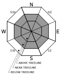
Avalanche Problem 1: Wind Slab
-
Character ?

-
Aspect/Elevation ?
-
Likelihood ?CertainVery LikelyLikelyPossible
 Unlikely
 -
Size ?HistoricVery LargeLargeSmall

Finding and triggering a wind slab that is large enough to threaten human life today will be very difficult.
Standard backcountry travel precautions for wind slabs include:
*Keeping an eye out for smooth, rounded, lens shaped, pillow shaped, chalky-white looking "slabs"
*"Sound" the slabs...they'll often sound hollow like a drum...the more drum-like, the more dangerous
*You might notice shooting cracks...the longer the crack, the more dangerous
*Falling through a harder surface layer into softer snow below. You can easily feel this with a ski pole or a snowmobile track punching through.
*Hardness: can be very soft to so hard you can hardly kick a boot into it
*What should you do if you find a wind slab on a steep slope:
*Stop immediately. Don't go any farther!
*Back off if you're on a big slope and dig down to investigate how well the slab is bonded to the underlying snow. If your unsure of how to do this, back off and choose a slope that is not as steep
*Jump on a few safe, test slopes to see how the snow responds
If the slab breaks away easily on your tests, don't cross larger slopes. Find another route that avoids wind slabs
Forecast Discussion
Mount Shasta is going to need some fresh snow for significant avalanche concerns to come into play. Variable snow conditions with the potential of hitting a rock(s) dominates. Folks are still enjoying the backcountry... just be cautious.
Castle Lake and Mt Eddy are starved for snow. Winter recreation is on hold in these areas for now. East of Mt Shasta in the Military Pass/Ash Creek Butte area, a thin snowpack still exists. Sledders will be compromising there snowmobiles due to dirt and rock patches. The recreation of choice for this area seems to be four-wheeling. Please stay on designated roadways. Bring a shovel!
Recent Observations
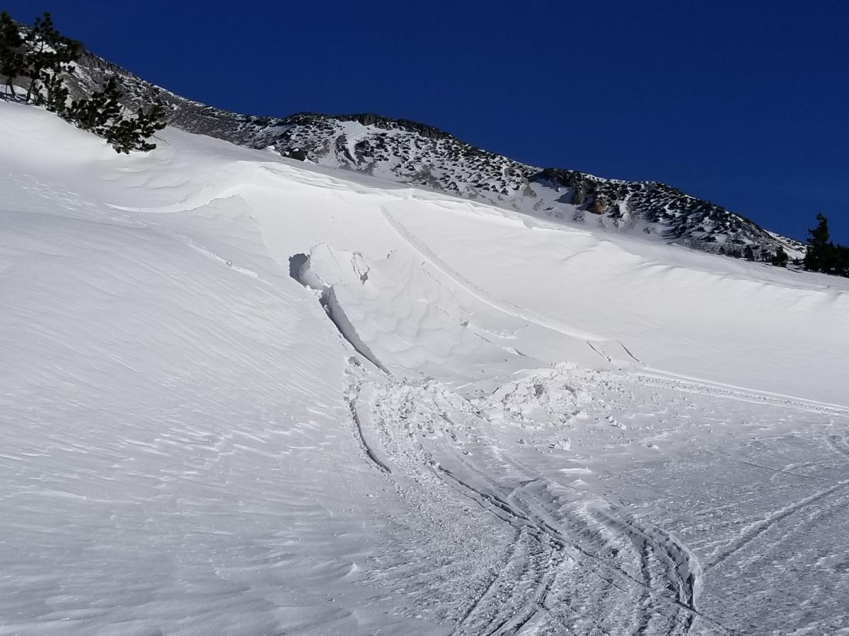
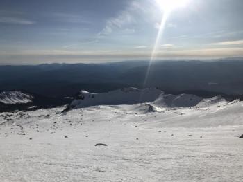
*A rider submitted a photo of a small snowmobile triggered wind slab (D1-R1) avalanche off a south facing road cut in the Old Ski Bowl (see photo below). This is the only avalanche we've observed since the Tuesday evening storm.
*New snow totals (from Tuesday night) average 2-4 inches. Some areas are scoured to old snow.
*The best snow coverage still exists in sheltered areas, concavities, gullies and depressions near and above treeline, with the exception of ridgelines and any other areas exposed to wind. Upper mountain slopes are scoured and icy. A slide for life is still possible.
*A few patches of corn snow was reported in Avalanche Gulch yesterday. Temperatures are considerably warmer this morning, +/- 10 degrees F.
*Winds were calm yesterday but have picked up last night and are blowing 15-25 mph out of the northwest currently.
*Many rocks are hidden and/or showing.

Weather and Current Conditions
Weather Summary
We slide down the backside of the work week into the holiday weekend with a few more days of mostly clear skies and moderate winds on Mt Shasta. The current high pressure system will continue until late Sunday morning when the next front arrives. Northern California will get brushed by this system and should get a blip of precipitation. Snow levels will hover around 4,500 feet. The brunt of the storm will impact Oregon. A white Christmas is looking promising...just enough to grease the skids of Santa's sleigh. Until then, expect partly cloudy skies and a slight increase in air temperature. Winds will slowly swing around from northwest to west/southwest by tomorrow.
---------------------------------------------------
THIS SEASON PRECIPITATION for MT SHASTA CITY: Since October 1st (the wet season), we have received 5.83 inches of water, normal is 12.60 inches, putting us at 46% of normal. For the month of December, we have received .29 inches of water, normal is 5.24 inches, which is 5% of normal. And finally for the year of 2017, we received 44.82 inches of water, normal is 40.60 inches, putting us at 110% of normal.
Always check the weather before you attempt to climb Mt Shasta. Further, monitor the weather as you climb. Becoming caught on the mountain in any type of weather can compromise life and limb. Be prepared.
24 Hour Weather Station Data @ 4:00 AM
| Weather Station | Temp (°F) | Wind (mi/hr) | Snow (in) | Comments | ||||||||
|---|---|---|---|---|---|---|---|---|---|---|---|---|
| Cur | Min | Max | Avg | Avg | Max Gust | Dir | Depth | New | Water Equivalent | Settlement | ||
| Mt. Shasta City (3540 ft) | 28 | 27 | 46 | 37 | 3 | N | ||||||
| Sand Flat (6750 ft) | 37 | 12 | 37 | 26 | 15 | 0 | 0 | 1 | ||||
| Ski Bowl (7600 ft) | 38 | 16 | 42 | 36 | 20 | 0 | 0 | 1 | ||||
| Gray Butte (8000 ft) | 36 | 23 | 38 | 35 | 14 | 43 | NW | |||||
| Castle Lake (5870 ft) | 39 | 17 | 40 | 29 | 7 | 9 | 6 | |||||
| Mount Eddy (6509 ft) | 39 | 24 | 41 | 33 | 2 | 11 | WSW | 12 | 1 | 2 | ||
| Ash Creek Bowl (7250 ft) | Station Down | |||||||||||
| Ash Creek Ridge (7895 ft) | Station Down |
Two Day Mountain Weather Forecast
Produced in partnership with the Medford NWS
| For 7000 ft to 9000 ft | |||
|---|---|---|---|
|
Friday (4 a.m. to 10 p.m.) |
Friday Night (10 p.m. to 4 a.m.) |
Saturday (4 a.m. to 10 p.m.) |
|
| Weather | Partly sunny | Mostly cloudy | Partly sunny |
| Temperature (°F) | 37 | 30 | 40 |
| Wind (mi/hr) | West/Northwest becoming southwest 5-10 mph | Southwest 5-10 mph | South 5-10 mph |
| Precipitation SWE / Snowfall (in) | / 0 | / 0 | / 0 |
| For 9000 ft to 11000 ft | |||
| Friday | Friday Night | Saturday | |
| Weather | Partly sunny, windy | Mostly cloudy, windy | Partly sunny, windy |
| Temperature (°F) | 26 | 24 | 29 |
| Wind (mi/hr) | West 20-30 mph | West 0 | West 20-30 mph |
| Precipitation SWE / Snowfall (in) | / 0 | / 0 | / 0 |

