

You are here
Avalanche Advisory for 2017-12-24 06:45:08
- EXPIRED ON December 25, 2017 @ 6:45 amPublished on December 24, 2017 @ 6:45 am
- Issued by Andrew Kiefer - Mt Shasta Avalanche Center
Bottom Line
Triggering an avalanche is unlikely, and LOW avalanche danger exists at all elevations. Watch for unstable snow on isolated terrain features. Shallow snowpack hazards are still problematic. Climbers and ski mountaineers should use extreme caution on steep slopes at upper elevations where icy and firm snow surfaces are widespread.


Avalanche Problem 1: Normal Caution
-
Character ?

-
Aspect/Elevation ?
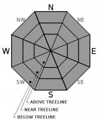
-
Likelihood ?CertainVery LikelyLikelyPossible
 Unlikely
 -
Size ?HistoricVery LargeLargeSmall

Normal caution is advised:
*Watch for isolated slabs.
*Ski and ride one at a time in avalanche terrain.
*Don't regroup in run out zones
*Basic avalanche rescue skills are always essential when you travel in avalanche terrain.
Isolated slabs are generally related to wind and terrain: look for places where small areas of drifting have occurred and firm layers of surface snow overlie softer layers. Often this will occur on the lee side of ridges, in terrain depressions, on convex terrain features, and in the lee of isolated bands of trees.
Forecast Discussion
We may get a dusting of snow over the next 24 hours, but skies should be clear and sunny by Christmas day. Precipitation so far this wet season is well below average, but don’t loose hope, we still have the whole winter ahead of us. We can be thankful that a resilient snowpack exists on Mount Shasta, and that all types of winter recreation are possible this holiday season. It is also a treat that generally safe avalanche conditions exist in the backcountry. If you venture out, continue to watch for shallowly buried objects and firm and icy snow surfaces. Expect LOW danger and normal caution to continue until a significant precipitation event occurs.
Recent Observations
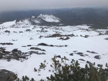
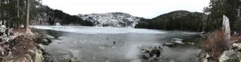
Evidence of the recent storm is starting to disappear. Hard and icy old snow dominates the surface of the snowpack. Alpine ridgelines, wind exposed areas, and very steep southerly slopes on Mount Shasta have little to no snow. Wind has deposited snow in gully features and concavities, and on lee slopes. In south facing terrain below 10,000ft, snow surfaces softened yesterday and were moist. North facing and shady slopes are still holding 4 inches of low-density snow at the surface of the snowpack. No signs of instability or evidence of a wind slab problem were observed yesterday on the south side of Mount Shasta. Coverage is still sparse with 1-3ft of snowpack at 7,000ft and up on Shasta, 1-2ft at 6,000ft and up in the Ash Creek Butte area, and very limited snow cover elsewhere in the advisory area.
Weather and Current Conditions
Weather Summary
A series of fronts will move through the region over the next 24 hours. There is a chance for precipitation between 10am and 4pm today. Expect a dusting of snow in the mountains at best, and light rain in town. Freezing levels will hover near 5,000ft. High temperatures will reach near 40 degrees at 6,000ft, while winds will blow out of the southwest, shifting northwest overnight. Clouds may linger into Christmas morning, but should dissipate by mid-day allowing for sunshine and clear skies. Northwest winds will be strong and gusty at upper elevations tomorrow, and another weak system brings a slight chance for precipitation again on Tuesday.
---------------------------------------------------
THIS SEASON PRECIPITATION for MT SHASTA CITY: Since October 1st (the wet season), we have received 5.83 inches of water, normal is 13.15 inches, putting us at 44% of normal. For the month of December, we have received .29 inches of water, normal is 5.79 inches, which is 5% of normal. And finally for the year of 2017, we received 44.82 inches of water, normal is 41.15 inches, putting us at 109% of normal.
Always check the weather before you attempt to climb Mt Shasta. Further, monitor the weather as you climb. Becoming caught on the mountain in any type of weather can compromise life and limb. Be prepared.
24 Hour Weather Station Data @ 3:00 AM
| Weather Station | Temp (°F) | Wind (mi/hr) | Snow (in) | Comments | ||||||||
|---|---|---|---|---|---|---|---|---|---|---|---|---|
| Cur | Min | Max | Avg | Avg | Max Gust | Dir | Depth | New | Water Equivalent | Settlement | ||
| Mt. Shasta City (3540 ft) | 36 | 30 | 50 | 39 | 0 | N | ||||||
| Sand Flat (6750 ft) | 36 | 32 | 39 | 35 | 15 | 0 | 0 | 0 | ||||
| Ski Bowl (7600 ft) | 36 | 32 | 42 | 35 | 19 | 0 | 0 | 0 | ||||
| Gray Butte (8000 ft) | 36 | 31 | 39 | 35 | 14 | 37 | WNW | |||||
| Castle Lake (5870 ft) | 39 | 34 | 40 | 37 | 0 | 0 | 0 | |||||
| Mount Eddy (6509 ft) | 39 | 32 | 40 | 37 | 2 | 6 | WSW | 10 | 0 | 0 | ||
| Ash Creek Bowl (7250 ft) | Station Down | |||||||||||
| Ash Creek Ridge (7895 ft) | Station Down |
Two Day Mountain Weather Forecast
Produced in partnership with the Medford NWS
| For 7000 ft to 9000 ft | |||
|---|---|---|---|
|
Sunday (4 a.m. to 10 p.m.) |
Sunday Night (10 p.m. to 4 a.m.) |
Monday (4 a.m. to 10 p.m.) |
|
| Weather | 30% chance of snow, mainly between 10am and 4pm. Mostly Cloudy | 20% chance of snow before 10pm. Mostly cloudy. | Sunny |
| Temperature (°F) | 39 | 38 | 41 |
| Wind (mi/hr) | South 9-16 mph | Southwest becoming Northwest 11 mph | North/Northwest 10-14 mph, Gusting 22 mph |
| Precipitation SWE / Snowfall (in) | / <1 inch | / 0 | / 0 |
| For 9000 ft to 11000 ft | |||
| Sunday | Sunday Night | Monday | |
| Weather | 30% chance of snow after 10am. Mostly cloudy. Wind chill values as low as 0 F. Windy. | 30% chance of showers before 10pm. Mostly cloudy. | Mostly sunny and windy. |
| Temperature (°F) | 23 | 23 | 29 |
| Wind (mi/hr) | Southwest 28-38 mph, Gusting 90 mph | West/Northwest <1 inch | Northwest 37-46 mph, Gusting 70 mph |
| Precipitation SWE / Snowfall (in) | / <1 inch | / 0 | / 0 |

