

You are here
Avalanche Advisory for 2018-01-19 06:44:08
- EXPIRED ON January 20, 2018 @ 6:44 amPublished on January 19, 2018 @ 6:44 am
- Issued by Nick Meyers - Shasta-Trinity National Forest
Bottom Line
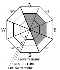
The wind slab problem will continue due to strong westerly winds and new snow over the past 24 hours. Near and above treeline, MODERATE avalanche danger exists on leeward, wind loaded N-NE-E-SE facing slopes. A human triggered wind slab is possible today, especially on unsupported slopes steeper than 35 degrees. Below treeline, the avalanche danger is LOW.
Icy surfaces still exist on windward, exposed ridgelines and a slide for life is possible without immediate self-arrest.


Avalanche Problem 1: Wind Slab
-
Character ?

-
Aspect/Elevation ?
-
Likelihood ?CertainVery LikelyLikelyPossible
 Unlikely
 -
Size ?HistoricVery LargeLargeSmall

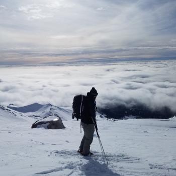
Westerly winds have averaged 18 mph, with gusts to 49 mph, on Grey Butte (8,000 ft) over the last 24 hours. Rapid loading of new snow has and will continue to build wind slabs near and above treeline today. Wind slabs can be expected on N-NE-E-SE aspects. Look for blowing snow, new cornice formation and wind pillows as clues to where wind slabs are forming. Avoid steep wind loaded terrain.
Areas such as the entire east aspects of Casaval and Green Butte ridgelines, the north aspect of Green Butte proper, the Trinity Chutes, Sun Bowl & Powder Bowl should all be taken seriously today.
Forecast Discussion
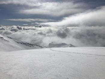
For our maritime snowpack, most avalanche activity occurs immediately during or just after storm cycles. And remember, it doesn't have to be snowing for there to be avalanche danger. Wind can deposit snow onto leeward slopes 10 times faster than snow falling from the sky. Poor visibility made for limited observations yesterday, so some uncertainty exists. Use caution when traveling in near and above treeline avalanche terrain today. Lastly, watch out for snow snakes! Many rocks are now well hidden with the fresh snow.
Recent Observations
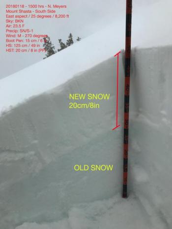
- Storm event yesterday (1.18.18) began at 0400 and ended at 2000. Snow level dropped to 5,600 ft. Total SWE: .82" (measured at Old Ski Bowl Wx Station)
- New snow: Bunny Flat, 6,950 ft - 6 in (15 cm) / Old Ski Bowl, 8,200 ft - 8 in (20 cm)
- Below & near treeline, winds calm with moderate gusts out of the west. Above treeline, gale force wind speeds along ridgelines and exposed areas, westerly. Widespread wind loading observed.
- Uniform deposition of new snow up to 8,500 ft. Transitional from 8,500 ft to 9,000 ft. Uneven distribution of new snow above this elevation with old, icy snow surfaces on windward SW-W-NW facing moraine tops and ridgelines. Ice patches were rock hard.
- Gullies and leeward wind drifts held 8-13 inches (20-35 cm) of new snow.
- Stability tests could not identify a notable slab and/or weak layer at 8,200 foot pit location.
- Old/new snow interface bonded well
- Visibility poor for most of the day. No recent avalanches were observed during a few short glimpses through the clouds and fog.
- Temperatures steady in mid 20's F.
- Many rocks now buried and lurking beneath new snow.
Weather and Current Conditions
Weather Summary
Precipitation is fading over Northern California this morning. Lingering snow showers are possible today with a chance of an additional .10 in SWE. An inch or two of new snow is possible but otherwise expect a general drying out for the next 48 hours. Westerly winds will die off in comparison to yesterday, but still, expect wind speeds high enough to continue to move fresh snow around. It feels wintery finally. Steady daytime highs and lows will continue for the weekend. Sunday, another round of weather will come through.
Always check the weather before you attempt to climb Mt Shasta. Further, monitor the weather as you climb. Becoming caught on the mountain in any type of weather can compromise life and limb. Be prepared.
24 Hour Weather Station Data @ 4:00 AM
| Weather Station | Temp (°F) | Wind (mi/hr) | Snow (in) | Comments | ||||||||
|---|---|---|---|---|---|---|---|---|---|---|---|---|
| Cur | Min | Max | Avg | Avg | Max Gust | Dir | Depth | New | Water Equivalent | Settlement | ||
| Mt. Shasta City (3540 ft) | 31 | 31 | 43 | 38 | 2 | N | ||||||
| Sand Flat (6750 ft) | 21 | 21 | 33 | 28 | 15 | 7 | 1 | 1 | ||||
| Ski Bowl (7600 ft) | 17 | 17 | 30 | 24 | 32 | 8 | .82 | 1 | ||||
| Gray Butte (8000 ft) | 17 | 17 | 29 | 23 | 18 | 49 | W | |||||
| Castle Lake (5870 ft) | 31 | 31 | 33 | 32 | 0 | 0 | 0 | snow depth suspect | ||||
| Mount Eddy (6509 ft) | 18 | 17 | 32 | 27 | 0 | 6 | VAR | 17.5 | 8 | 1 | ||
| Ash Creek Bowl (7250 ft) | Station down | |||||||||||
| Ash Creek Ridge (7895 ft) | Station down |
Two Day Mountain Weather Forecast
Produced in partnership with the Medford NWS
| For 7000 ft to 9000 ft | |||
|---|---|---|---|
|
Friday (4 a.m. to 10 p.m.) |
Friday Night (10 p.m. to 4 a.m.) |
Saturday (4 a.m. to 10 p.m.) |
|
| Weather | Lingering snow showers, partly cloudy | Partly to mostly cloudy | Partly cloudy |
| Temperature (°F) | 28 | 24 | 31 |
| Wind (mi/hr) | Southwest 5-10 mph | West 0-5 mph | Northwest 5-10 mph |
| Precipitation SWE / Snowfall (in) | / 0-1 | / 0 | / 0 |
| For 9000 ft to 11000 ft | |||
| Friday | Friday Night | Saturday | |
| Weather | Snow showers tapering off, breezy | Partly to mostly cloudy | Partly cloudy |
| Temperature (°F) | 8 | 8 | 12 |
| Wind (mi/hr) | West 15-20 mph | Northwest 1-2 | Northwest 15-20 mph |
| Precipitation SWE / Snowfall (in) | / 1-2 | / 0 | / 0 |
Season Precipitation for Mount Shasta City
| Period | Measured (in) | Normal (in) | Percent of Normal (%) |
|---|---|---|---|
| From Oct 1, 2023 (the wet season) | 8.64 | 19.48 | 44 |
| Month to Date (since Apr 1, 2024) | 2.81 | 4.27 | 66 |
| Year to Date (since Jan 1, 2024) | 2.81 | 4.27 | 66 |

