

You are here
Avalanche Advisory for 2018-01-21 07:01:45
- EXPIRED ON January 22, 2018 @ 7:01 amPublished on January 21, 2018 @ 7:01 am
- Issued by Andrew Kiefer - Mt Shasta Avalanche Center
Bottom Line
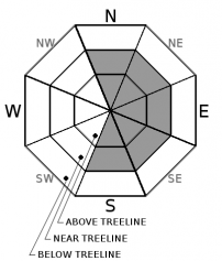
MODERATE avalanche danger exists near and above treeline. Watch for fresh wind slabs above 8,000ft on S-SE-E-NE-N aspects. A winter storm will begin this morning and avalanche danger is expected to rise this afternoon and by tomorrow. Monitor changing conditions throughout the day.


Avalanche Problem 1: Wind Slab
-
Character ?

-
Aspect/Elevation ?
-
Likelihood ?CertainVery LikelyLikelyPossible
 Unlikely
 -
Size ?HistoricVery LargeLargeSmall

Snowfall and strong westerly winds will create fresh wind slabs near and above treeline on S-SE-E-NE-N aspects. Human triggered wind slab avalanches will be possible on leeward slopes and terrain features 35 degrees and steeper above 8,000 ft. Watch for new wind slab development throughout the day as winds increase and snow accumulates. Wind slabs could be 1-3 ft thick. In specific wind loaded areas, it will be possible to trigger a wind slab by the end of today that could be large enough to bury, injure, or kill a person.
Forecast Discussion
The storm today will bring snowfall, strong westerly winds, and cold temperatures. Snow forecasts have downgraded right before show time once again. However, the new snow and wind will likely create increasing avalanche danger late this afternoon and overnight. Pay close attention to the obvious signs of wind slab development: blowing snow, cornice formation, wind pillows, hollow sounding snow and textured snow surfaces.
Recent Observations
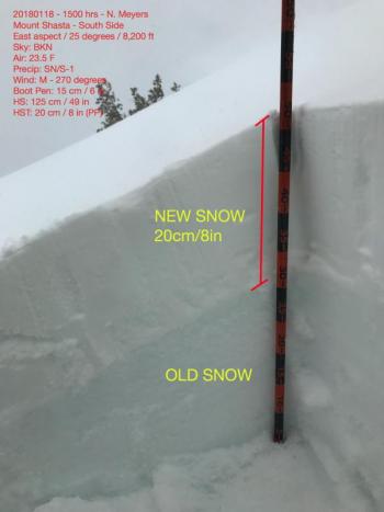
Clear and cold weather made for a gorgeous morning yesterday. Patchy clouds began to move in around 11am, but periods of sunshine continued throughout the afternoon. Overnight, winds shifted to the west averaging 10-15 mph with gusts to 25 mph at 8,000 ft. A trace amount of snow accumulated yesterday, and our recent storm snow has settled 1-2 inches. Snow surfaces have remained cold and dry. Above 9,000 ft, winds have been transporting snow onto S-SE-E-NE-N slopes and scouring ridgelines and exposed terrain features down to a slick icy surface. No avalanches have been observed or reported in several days.
Weather and Current Conditions
Weather Summary
The NWS has issued a Winter Storm Warning in effect until 1AM Monday. A cold front is approaching the coast and will bring strong westerly winds and low elevation snowfall today. The bulk of precipitation will come between 10am-10pm, with lingering snow showers overnight. By Monday morning, the advisory area should receive .4 inches of water with snow levels staying at or below 4,000 ft. For areas 6,000 ft and above, expect 3-7 inches of snow for today, with an additional 3-6 inches tonight. High temperatures in the mountains will be in the low 20’s today with strong westerly winds. The cold front will move out of the area tonight, and a warming trend will be associated with the tail end of the storm. Monday should be dry. Another strong cold front will affect the area Tuesday night and Wednesday.
24 Hour Weather Station Data @ 6:00 AM
| Weather Station | Temp (°F) | Wind (mi/hr) | Snow (in) | Comments | ||||||||
|---|---|---|---|---|---|---|---|---|---|---|---|---|
| Cur | Min | Max | Avg | Avg | Max Gust | Dir | Depth | New | Water Equivalent | Settlement | ||
| Mt. Shasta City (3540 ft) | 29 | 27 | 42 | 32 | 2 | N | ||||||
| Sand Flat (6750 ft) | 19 | 14 | 26 | 19 | 16 | 1 | 0 | 0 | ||||
| Ski Bowl (7600 ft) | 20 | 13 | 26 | 19 | 30 | 1 | .1 | 1 | ||||
| Gray Butte (8000 ft) | 16 | 14 | 25 | 18 | 6 | 25 | WNW | |||||
| Castle Lake (5870 ft) | 25 | 20 | 28 | 24 | 3 | 0 | 0 | |||||
| Mount Eddy (6509 ft) | 20 | 16 | 26 | 21 | 2 | 4 | VAR | 15 | 0 | 2 | ||
| Ash Creek Bowl (7250 ft) | station down | |||||||||||
| Ash Creek Ridge (7895 ft) | station down |
Two Day Mountain Weather Forecast
Produced in partnership with the Medford NWS
| For 7000 ft to 9000 ft | |||
|---|---|---|---|
|
Sunday (4 a.m. to 10 p.m.) |
Sunday Night (10 p.m. to 4 a.m.) |
Monday (4 a.m. to 10 p.m.) |
|
| Weather | Snow, mainly after 10am. Chance of precipitation 100%. Wind chill values as low as -8 degrees F. | Snow showers. Chance of precipitation 100%. Wind chill values as low as -8 degrees F. Temperatures rising to 29 degrees by 4am. | Snow showers likely, mainly before 10am. Mostly cloudy. |
| Temperature (°F) | 17 | 13 | 31 |
| Wind (mi/hr) | South 15-25 mph | South 20-25 mph | South/Southeast 10-15 mph |
| Precipitation SWE / Snowfall (in) | / 5-9 | / 3-7 | / < 1 |
| For 9000 ft to 11000 ft | |||
| Sunday | Sunday Night | Monday | |
| Weather | Heavy snow and windy, mainly after 10am. Chance of precipitation 100%. Wind chill values as low as -18 degrees F. | Snow showers between 10pm-4am. Windy. Chance of precipitation 100%. Wind chill values as low as -18 degrees F. Temperatures rising to around 21 degrees by 4am. | A 50% chance of snow showers mainly before 10am. Mostly cloudy. Wind chill values as low as -10 degrees F. |
| Temperature (°F) | 12 | 10 | 20 |
| Wind (mi/hr) | West/Southwest 30-40 mph, gusting 50+ mph | West/Southwest 6-10 | West 25-35 mph |
| Precipitation SWE / Snowfall (in) | / 6-10 | / 5-9 | / < 1 |
Season Precipitation for Mount Shasta City
| Period | Measured (in) | Normal (in) | Percent of Normal (%) |
|---|---|---|---|
| From Oct 1, 2023 (the wet season) | 8.64 | 19.91 | 43 |
| Month to Date (since Apr 1, 2024) | 2.81 | 4.70 | 60 |
| Year to Date (since Jan 1, 2024) | 2.81 | 4.70 | 60 |

