

You are here
Avalanche Advisory for 2018-01-23 06:53:47
- EXPIRED ON January 24, 2018 @ 6:53 amPublished on January 23, 2018 @ 6:53 am
- Issued by Andrew Kiefer - Mt Shasta Avalanche Center
Bottom Line
The avalanche danger is LOW at all elevations. Shallow wind slabs still exist on S-SE-E-NE-N aspects above 9,000 ft on Mount Shasta. Expect increasing avalanche danger tomorrow through the end of the week as a significant winter storm impacts the area.


Avalanche Problem 1: Wind Slab
-
Character ?

-
Aspect/Elevation ?
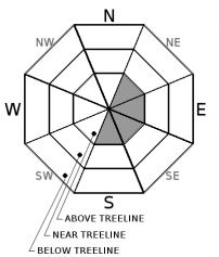
-
Likelihood ?CertainVery LikelyLikelyPossible
 Unlikely
 -
Size ?HistoricVery LargeLargeSmall

The wind slab problem remains a concern in isolated areas. Continue to watch for wind slabs on S-SE-E-NE-NE slopes 35 degrees and steeper above treeline. All recent observations indicate wind slabs are very stubborn to trigger. Today, both natural and human triggered wind slab avalanches are unlikely.
Forecast Discussion
A major winter storm will approach the advisory area today. LOW avalanche danger exists for now, but expect significant change by tomorrow. The storms this past weekend noticeably improved snow cover in terrain above 8,000 ft. Shallow snowpack hazards still exist below treeline. Continue to watch for wind slabs in leeward terrain above 9,000 ft on Mount Shasta.
Recent Observations
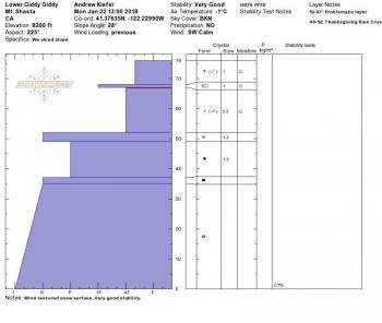
The recent storm added 3-6 inches of new snow throughout the advisory area – the first time snow has accumulated below 4,000 ft all season. Above 6,500 ft, the new snow added a pleasant refresh to our shallow snowpack. Based on observations yesterday from Giddy Giddy Gulch, Avalanche Gulch, the Old Ski Bowl, and Grey Butte, snowpack stability is good. No recent avalanches have been observed nor have any major signs of instability. Wind slabs were hard to find. Northwest winds were seen transporting snow above 10,000 ft with minimal loading on leeward slopes. Wind textured snow surfaces were widespread above 8,000 ft. Periods of sunshine and clear skies broke up the clouds throughout the day. Exposed terrain features were scoured down to a slick and icy old snow surface. A thin sun crust formed on steep, open south facing slopes below 9,000 ft.
Weather and Current Conditions
Weather Summary
A significant frontal system will arrive late tonight, bringing heavy precipitation and strong southerly winds through Wednesday. Today, expect mostly cloudy skies with periods of sunshine, highs in mid 30s to low 40s, and moderate south/southwest winds. The NWS has issued a WINTER STORM WARNING IN EFFECT FROM 4AM TO 10PM PST WEDNESDAY ABOVE 3500 FEET. Light snowfall is expected after 10pm tonight with 1-3 inches of snow possible by morning. Heavy snowfall will begin by 4am, with over 1 inch of water forecast by 10pm Wednesday. During the day on Wednesday, 10-15 inches of snow will likely accumulate in areas 6,000 ft and above. Snow levels for the storm should start out near 4,000 ft and drop to town level by Wednesday afternoon. Colder air will arrive Wednesday night into Thursday with continued snow showers.
24 Hour Weather Station Data @ 6:00 AM
| Weather Station | Temp (°F) | Wind (mi/hr) | Snow (in) | Comments | ||||||||
|---|---|---|---|---|---|---|---|---|---|---|---|---|
| Cur | Min | Max | Avg | Avg | Max Gust | Dir | Depth | New | Water Equivalent | Settlement | ||
| Mt. Shasta City (3540 ft) | 28 | 27 | 40 | 33 | 0 | N | ||||||
| Sand Flat (6750 ft) | 19 | 18 | 32 | 24 | 18 | 0 | 0 | 2 | ||||
| Ski Bowl (7600 ft) | 26 | 16 | 27 | 23 | 35 | 0 | 0 | 2 | ||||
| Gray Butte (8000 ft) | 22 | 18 | 28 | 22 | 8 | 31 | WNW | |||||
| Castle Lake (5870 ft) | 26 | 25 | 36 | 27 | 3 | 0 | 1 | |||||
| Mount Eddy (6509 ft) | 26 | 19 | 30 | 24 | 2 | 6 | SW | 20 | 0 | 1 | ||
| Ash Creek Bowl (7250 ft) | station down | |||||||||||
| Ash Creek Ridge (7895 ft) | station down |
Two Day Mountain Weather Forecast
Produced in partnership with the Medford NWS
| For 7000 ft to 9000 ft | |||
|---|---|---|---|
|
Tuesday (4 a.m. to 10 p.m.) |
Tuesday Night (10 p.m. to 4 a.m.) |
Wednesday (4 a.m. to 10 p.m.) |
|
| Weather | Mostly cloudy. | 40% chance of snow after 10pm. Mostly cloudy. | 100% chance of snow. The snow could be heavy at times. Windy. |
| Temperature (°F) | 34 | 26 | 30 |
| Wind (mi/hr) | Sout 5-10 mph | South 10-15 mph | South 15-20 mph |
| Precipitation SWE / Snowfall (in) | / 0 | / 1-3 | / 14-20 |
| For 9000 ft to 11000 ft | |||
| Tuesday | Tuesday Night | Wednesday | |
| Weather | Partly sunny and windy. | 40% chance of snow after 10pm. Mostly cloudy. | Heavy snow and windy. Chance of precipitation 100%. |
| Temperature (°F) | 24 | 17 | 17 |
| Wind (mi/hr) | southwest 25-30 mph, increasing throughout the day | South/Southwest 0 | West/Southwest 35-45 mph, gusting 60+ mph |
| Precipitation SWE / Snowfall (in) | / 0 | / 3-5 | / 20-28 |
Season Precipitation for Mount Shasta City
| Period | Measured (in) | Normal (in) | Percent of Normal (%) |
|---|---|---|---|
| From Oct 1, 2023 (the wet season) | 9.07 | 20.13 | 45 |
| Month to Date (since Apr 1, 2024) | 3.24 | 4.92 | 66 |
| Year to Date (since Jan 1, 2024) | 3.24 | 4.92 | 66 |

