

You are here
Avalanche Advisory for 2018-01-26 06:40:19
- EXPIRED ON January 27, 2018 @ 6:40 amPublished on January 26, 2018 @ 6:40 am
- Issued by Nick Meyers - Shasta-Trinity National Forest
Bottom Line
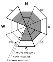
Below treeline, the avalanche danger is LOW. Near and above treeline, expect MODERATE avalanche danger for existing wind slab avalanches. Natural activity is unlikely, human triggered slabs are possbile in steep terrain. Fresh, low density snow and increasing west/southwest winds over the next 24 hours will continue to add snow to leeward SE-E-NE aspects. A stubborn wind slab today could be touchy tomorrow.


Avalanche Problem 1: Wind Slab
-
Character ?

-
Aspect/Elevation ?
-
Likelihood ?CertainVery LikelyLikelyPossible
 Unlikely
 -
Size ?HistoricVery LargeLargeSmall

Natural wind slab avalanches are unlikely today. Human triggered wind slabs are possible. Recent low density storm snow remains available for transport. Winds have been light over the past 24 hours, but will increase tonight into Saturday. Existing wind slabs will be stubborn to cut loose but could be large if triggered. West/Southwest winds have primarily loaded NE-E-SE facing slopes and cross-loaded some more northerly and southerly slopes also. Expect new wind slabs to develop as winds increase out of the southwest over the next 24 hours. Look for signs of wind loading like blowing snow, cornices, textured snow surfaces and hollow sounding snow.
Forecast Discussion
We've been unable to find good evidence to support the continuation of the loose dry and storm slab avalanche problems for today. Overall, the new storm snow seems to be resting easy and stability has been good, below and near treeline. We don't want to give false confidence however. Observations from the alpine have been limited and thus, our biggest concern remains with the wind slab problem. The game we must play is balancing the ebb and flow of stubborn to potentially touchy wind slabs during and after storm cycles. It doesn't have to be snowing for avalanches to be possible. Precipitation fades into the weekend, the wind will increase. Don't let powder fever take you under. Continue to exercise cautious route finding and conservative decision-making skills!
Recent Observations
- Yesterday's storm produced .36" SWE (Snow-Water Equivalent) and added 10 to 15 cm (4-6 in) of new snow above 7,500 feet from 0600 - 2200 hrs
- Storm total over the past 2 days approximately 16-20 inches (40-50 cm)
- Winds calm to light with a few moderate gusts.
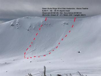
- Small cornices on E-NE aspects were easily triggered along ridgelines on Grey Butte, near and above treeline
- One large crack, associated with the wind slab problem, was triggered above treeline in between Sun Bowl and Powder Bowl (Criblet Ridge)
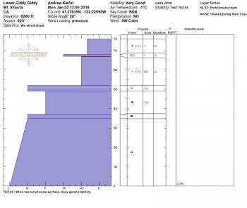
- Observations from Lower Giddy Giddy, the Promise Land and Anaconda did not reveal any obvious signs of avalanche danger. This terrain is west and northwest of Horse Camp, near and above treeline on the lower flanks of Mount Shasta.
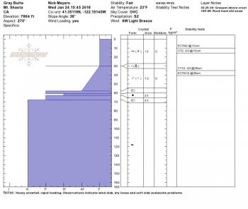
- Top 40 cm of new snow has a notable density break from 4 finger to fist, down 15 cm from surface. This layer has produced easy, sudden planar fractures in compression tests. Extended column tests have produced numerous ECTN3-5 results (fracture, no propagation) with poor slab characteristics (Promise Land & Grey Butte areas)
- Below and near treeline and some southerly slopes above treeline, a thin ice crust (old snow / new snow interface) at 40 cm deep had significant temperature gradient (2.5 F, above / below crust). Moderate sudden planar fractures were possible just below crust, 41 cm below surface. (Grey Butte area)
- No recent, natural avalanches observed. Visibility has been poor.
Weather and Current Conditions
Weather Summary
High clouds stream ahead of the next approaching system. Increasing clouds today will lead to a chance of snow this afternoon and snow likely tonight. Mount Shasta will squeeze a tenth of an inch of water out of this storm. The brunt of the front is focused north of the area. Westerly flow will provide the majority of precipitation to the coast, near the California/Oregon border. Light to moderate winds will increase tonight on the mountain. Tomorrow is windy and not as cold. Sunday and beyond will be clear and warmer.
24 Hour Weather Station Data @ 4:00 AM
| Weather Station | Temp (°F) | Wind (mi/hr) | Snow (in) | Comments | ||||||||
|---|---|---|---|---|---|---|---|---|---|---|---|---|
| Cur | Min | Max | Avg | Avg | Max Gust | Dir | Depth | New | Water Equivalent | Settlement | ||
| Mt. Shasta City (3540 ft) | 30 | 28 | 35 | 32 | 2 | N | ||||||
| Sand Flat (6750 ft) | 15 | 15 | 24 | 20 | 28 | 3 | 0 | 0 | ||||
| Ski Bowl (7600 ft) | 13 | 13 | 19 | 17 | 49 | 4 | 0.36 | 1 | ||||
| Gray Butte (8000 ft) | 14 | 12 | 19 | 16 | 13 | 31 | W | |||||
| Castle Lake (5870 ft) | 20 | 19 | 28 | 23 | 16 | 4 | 1 | |||||
| Mount Eddy (6509 ft) | 17 | 17 | 25 | 20 | 1 | 9 | S | 30 | 4 | 1 | ||
| Ash Creek Bowl (7250 ft) | station down | |||||||||||
| Ash Creek Ridge (7895 ft) | station down |
Two Day Mountain Weather Forecast
Produced in partnership with the Medford NWS
| For 7000 ft to 9000 ft | |||
|---|---|---|---|
|
Friday (4 a.m. to 10 p.m.) |
Friday Night (10 p.m. to 4 a.m.) |
Saturday (4 a.m. to 10 p.m.) |
|
| Weather | Mostly cloudy with a 30% chance of snow showers, mainly after 4pm. Snow levels near town. | Mostly cloudy, chance of snow in the evening then snow likely after midnight. Snow levels near town. | Not as cold, snow likely in the morning, gradually clearing, some showers possible during the day. Snow levels near 4,600 ft. |
| Temperature (°F) | 28 | 26 | 37 |
| Wind (mi/hr) | South 0-5 mph | South 5-10 mph | South 10-15 mph |
| Precipitation SWE / Snowfall (in) | / .5-1 | / 1-2 | / .5-1 |
| For 9000 ft to 11000 ft | |||
| Friday | Friday Night | Saturday | |
| Weather | Mostly cloudy with a 30% chance of snow showers, mainly after 4pm. Breezy with wind chill values as low as -14 F. | Snow likely, mainly after 10pm. Windy with wind chill values as low as -7 F. | Snow likely, mainly before 10am. Mostly cloudy, gradually clearing. Windy. Wind chill values as low as -4 F. |
| Temperature (°F) | 19 | 19 | 28 |
| Wind (mi/hr) | Southwest 15-20 mph | Southwest .5-1 | Southwest 30-40 mph |
| Precipitation SWE / Snowfall (in) | / .5-1 | / 2-4 | / .5-1 |
Season Precipitation for Mount Shasta City
| Period | Measured (in) | Normal (in) | Percent of Normal (%) |
|---|---|---|---|
| From Oct 1, 2023 (the wet season) | 10.11 | 21.00 | 48 |
| Month to Date (since Apr 1, 2024) | 4.28 | 5.79 | 74 |
| Year to Date (since Jan 1, 2024) | 4.28 | 5.79 | 74 |

