

You are here
Avalanche Advisory for 2018-01-28 07:00:42
- EXPIRED ON January 29, 2018 @ 7:00 amPublished on January 28, 2018 @ 7:00 am
- Issued by Andrew Kiefer - Mt Shasta Avalanche Center
Bottom Line
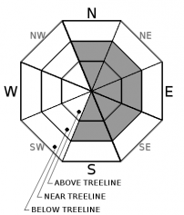
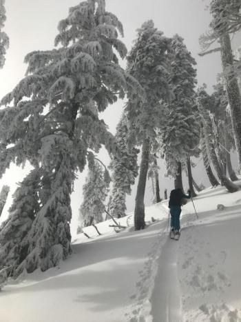
The avalanche danger is MODERATE near and above treeline. In these elevation bands, fresh wind slabs exist on S-SE-E-NE-N aspects. Human triggered avalanches are possible, while natural avalanches are unlikely. Warming temperatures today may weaken snow surfaces. Rime icefall will also be a significant concern. Below treeline, the avalanche danger is LOW.


Avalanche Problem 1: Wind Slab
-
Character ?

-
Aspect/Elevation ?
-
Likelihood ?CertainVery LikelyLikelyPossible
 Unlikely
 -
Size ?HistoricVery LargeLargeSmall

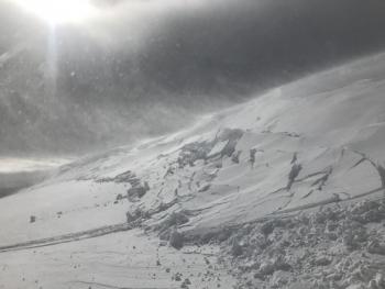
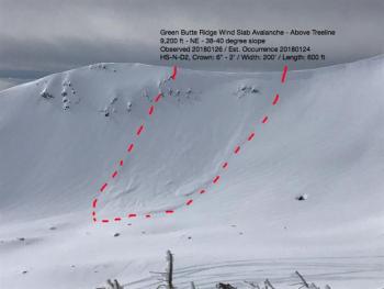
Human triggered wind slabs are possible near and above treeline on S-SE-E-NE-N slopes. Wind slabs could be 1-3 ft thick and could be large enough to bury, injure or kill a person. Natural and human triggered wind slabs have occurred recently. Westerly winds have been very productive in transporting snow and creating fresh wind slabs. Be especially careful of east facing slopes 35 degrees and steeper above treeline. Watch for blowing snow, cornices, textured snow surfaces and hollow sounding snow. Use scoured or wind protected areas to avoid the wind slab problem in steeper terrain.
Forecast Discussion
Although wind slabs are becoming stubborn to trigger, they continue to remain a concern. It will also be important to monitor the effects of warming temperatures on snow surfaces. Watch for roller balls, pinwheels and loose wet avalanches as the day progresses. Keep in mind that the immediate effects of warming today may promote instability in the snowpack, while the delayed effects will promote stability in the coming days. Additionally, falling rime ice will be a significant hazard in high alpine terrain on Mount Shasta.
Recent Observations
Yesterday brought mostly cloudy skies, strong winds, and a rapid warm up. For a brief period in the afternoon, rain fell up to 8,000 ft. Westerly winds continuously transported snow onto leeward slopes throughout the day.
A wind slab was triggered by a snowmobiler yesterday on an east-facing slope at 8,400 ft in the Old Ski Bowl. No one was caught or injured in the avalanche. The wind slab broke 1-3 ft deep, 250 ft wide but only ran 10-20 ft downslope. Although it was a relatively harmless avalanche, the propagation was very impressive. It is an obvious example of how human triggered wind slab avalanches are still possible.
The rain and above freezing temperatures rapidly warmed snow surfaces yesterday afternoon. Roller balls and pinwheels were widespread on steep slopes near and below treeline. Temperature inversions are in place this morning with above freezing temperatures recorded at the Old Ski Bowl and Grey Butte weather stations.

Weather and Current Conditions
Weather Summary
Expect mild weather and unseasonably warm temperatures across northern California today. Skies will be sunny, highs will reach 50 degrees at 6,000 ft and westerly winds will average 10-20 mph. Freezing levels will rise to 10,000 ft. Strong winds will develop on the upper mountain tomorrow and continue through Tuesday as a cold front moves in from the northwest. High pressure will follow for the remainder of the week.
24 Hour Weather Station Data @ 6:00 AM
| Weather Station | Temp (°F) | Wind (mi/hr) | Snow (in) | Comments | ||||||||
|---|---|---|---|---|---|---|---|---|---|---|---|---|
| Cur | Min | Max | Avg | Avg | Max Gust | Dir | Depth | New | Water Equivalent | Settlement | ||
| Mt. Shasta City (3540 ft) | 29 | 28 | 39 | 35 | 2 | N | ||||||
| Sand Flat (6750 ft) | 33 | 23 | 33 | 28 | 26 | 0 | 0 | 1 | ||||
| Ski Bowl (7600 ft) | 36 | 19 | 37 | 30 | 47 | 0 | 0 | 1 | ||||
| Gray Butte (8000 ft) | 32 | 18 | 32 | 28 | 16 | 49 | NW | |||||
| Castle Lake (5870 ft) | 34 | 23 | 38 | 33 | 13 | 0 | 1 | |||||
| Mount Eddy (6509 ft) | 31 | 21 | 39 | 32 | 3 | 16 | ESE | 28 | 0 | 2 | ||
| Ash Creek Bowl (7250 ft) | station down | |||||||||||
| Ash Creek Ridge (7895 ft) | station down |
Two Day Mountain Weather Forecast
Produced in partnership with the Medford NWS
| For 7000 ft to 9000 ft | |||
|---|---|---|---|
|
Sunday (4 a.m. to 10 p.m.) |
Sunday Night (10 p.m. to 4 a.m.) |
Monday (4 a.m. to 10 p.m.) |
|
| Weather | Sunny | Partly cloudy | Mostly cloudy |
| Temperature (°F) | 48 | 38 | 48 |
| Wind (mi/hr) | East becoming south in the afternon 5-10 mph | East 5-10 mph | South 10-15 mph |
| Precipitation SWE / Snowfall (in) | / 0 | / 0 | / 0 |
| For 9000 ft to 11000 ft | |||
| Sunday | Sunday Night | Monday | |
| Weather | Sunny and windy | Partly cloudy and windy | Mostly cloudy |
| Temperature (°F) | 33 | 33 | 26 |
| Wind (mi/hr) | West 10-20 mph, gusting 30mph | Southwest 0 | West/Southwest 30-40 mph with higher gusts |
| Precipitation SWE / Snowfall (in) | / 0 | / 0 | / 0 |
Season Precipitation for Mount Shasta City
| Period | Measured (in) | Normal (in) | Percent of Normal (%) |
|---|---|---|---|
| From Oct 1, 2023 (the wet season) | 10.11 | 21.43 | 47 |
| Month to Date (since Apr 1, 2024) | 4.28 | 6.22 | 69 |
| Year to Date (since Jan 1, 2024) | 4.28 | 6.22 | 69 |

