

You are here
Avalanche Advisory for 2018-01-29 06:47:11
- EXPIRED ON January 30, 2018 @ 6:47 amPublished on January 29, 2018 @ 6:47 am
- Issued by Andrew Kiefer - Mt Shasta Avalanche Center
Bottom Line
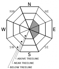
The avalanche danger is MODERATE above treeline and LOW near and below treeline. Wind slabs exist on SE-E-NE aspects above 9,000 ft where human triggering remains possible. With continued warm temperatures, falling rime ice is a concern above treeline on Mount Shasta.


Avalanche Problem 1: Wind Slab
-
Character ?

-
Aspect/Elevation ?
-
Likelihood ?CertainVery LikelyLikelyPossible
 Unlikely
 -
Size ?HistoricVery LargeLargeSmall

Wind slabs 1-3 ft thick exist above treeline on SE-E-NE aspects. Wind slabs have become stubborn to trigger above treeline and unreactive near treeline. The best place to trigger a wind slab today would be above 9,000 ft on an easterly aspect steeper than 35 degrees with a convex slope shape. Natural avalanches are unlikely. Watch for blowing snow, cornices, textured snow surfaces, and hollow sounding snow to detect the presence of wind slabs. Use scoured or wind protected areas to avoid the wind slab problem in steeper terrain.
Forecast Discussion
The recent storm ending on Friday was the most significant precipitation event of the season so far. Natural wind slab avalanches occurred above treeline on Wednesday immediately following the period of highest precipitation intensity, and on Saturday in response to a major westerly wind event and rapid warm up. Now, a few days after the storm, stability is improving and it is becoming hard to trigger an avalanche.
Recent Observations
Sunny skies, moderate westerly winds, and spring-like weather made for a beautiful day yesterday. Temperatures hit 50 degrees at the Old Ski Bowl weather station yesterday afternoon, and have remained in the 40s overnight.
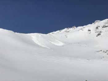
A natural wind slab avalanche occurred late in the afternoon or overnight on Saturday on a spur of Sargent’s Ridge dropping into St. Germaine’s Bowl. The avalanche occurred on an easterly aspect at 9,500 ft. The avalanche broke 1-3 ft deep, 200 ft wide and ran 100 ft downslope. Two other shallow natural wind slab avalanches were observed in the bowl behind Shastarama at 10,500 – 11,500 ft on southeast aspects. The avalanches occurred sometime during the recent storm late last week. These avalanches broke 1-2 ft deep, 50-100 ft wide, and ran 150 ft downslope.
Wind slabs were encountered yesterday in leeward terrain above treeline, most notably on easterly aspects above 9,000 ft.
Snow surfaces are variable. Breakable melt-freeze crusts, supportable wind crusts, hard icy surfaces, creamy damp powder snow, and dry powder snow were all encountered yesterday between 7,000-10,000ft on Mount Shasta.
Weather and Current Conditions
Weather Summary
Another day of mild weather will bring mostly cloudy skies, increasing southwest winds, and highs near 50 degrees at 6,000 ft. Strong winds will develop on the upper mountain this afternoon and continue through Wednesday. A weakening cold front will move inland today bringing modest snowfall from Mount McLoughlin northward, but will just miss northern California. Near normal temperatures should return tomorrow through Thursday. A strong ridge of high-pressure looks to lock in place by the end of the week bringing dry and warm weather to Mount Shasta for the foreseeable future.
24 Hour Weather Station Data @ 6:00 AM
| Weather Station | Temp (°F) | Wind (mi/hr) | Snow (in) | Comments | ||||||||
|---|---|---|---|---|---|---|---|---|---|---|---|---|
| Cur | Min | Max | Avg | Avg | Max Gust | Dir | Depth | New | Water Equivalent | Settlement | ||
| Mt. Shasta City (3540 ft) | 33 | 28 | 50 | 39 | 3 | N | ||||||
| Sand Flat (6750 ft) | 33 | 31 | 38 | 33 | 25 | 0 | 0 | 0 | ||||
| Ski Bowl (7600 ft) | 43 | 35 | 53 | 44 | 45 | 0 | 0 | 2 | ||||
| Gray Butte (8000 ft) | 43 | 32 | 47 | 43 | 10 | 25 | WNW | |||||
| Castle Lake (5870 ft) | 46 | 34 | 52 | 45 | 13 | 0 | 0 | |||||
| Mount Eddy (6509 ft) | 42 | 31 | 51 | 41 | 3 | 6 | WSW | 27 | 0 | 1 | ||
| Ash Creek Bowl (7250 ft) | station down | |||||||||||
| Ash Creek Ridge (7895 ft) | station down |
Two Day Mountain Weather Forecast
Produced in partnership with the Medford NWS
| For 7000 ft to 9000 ft | |||
|---|---|---|---|
|
Monday (4 a.m. to 10 p.m.) |
Monday Night (10 p.m. to 4 a.m.) |
Tuesday (4 a.m. to 10 p.m.) |
|
| Weather | Mostly cloudy | Mostly cloudy | Partly sunny and breezy |
| Temperature (°F) | 50 | 34 | 41 |
| Wind (mi/hr) | East/Southeast 5-10 mph | West/Southwest 10-15 mph | West/Northwest 10-20 mph |
| Precipitation SWE / Snowfall (in) | / 0 | / 0 | / 0 |
| For 9000 ft to 11000 ft | |||
| Monday | Monday Night | Tuesday | |
| Weather | Mostly cloudy and windy | Mostly cloudy and windy | Partly sunny and windy |
| Temperature (°F) | 33 | 25 | 29 |
| Wind (mi/hr) | West/Southwest 20-30 mph | West/Southwest 0 | West 35-45 mph with high gusts |
| Precipitation SWE / Snowfall (in) | / 0 | / 0 | / 0 |
Season Precipitation for Mount Shasta City
| Period | Measured (in) | Normal (in) | Percent of Normal (%) |
|---|---|---|---|
| From Oct 1, 2023 (the wet season) | 10.11 | 21.43 | 47 |
| Month to Date (since Apr 1, 2024) | 4.28 | 6.22 | 69 |
| Year to Date (since Jan 1, 2024) | 4.28 | 6.22 | 69 |

