

You are here
Avalanche Advisory for 2018-01-30 06:44:10
- EXPIRED ON January 31, 2018 @ 6:44 amPublished on January 30, 2018 @ 6:44 am
- Issued by Andrew Kiefer - Mt Shasta Avalanche Center
Bottom Line
Avalanches are unlikely, and the danger is LOW. Small wind slabs may still exist in isolated areas above 9,000 ft on SE-E-NE aspects. Falling rime ice is a significant concern above treeline on Mount Shasta.


Avalanche Problem 1: Wind Slab
-
Character ?

-
Aspect/Elevation ?
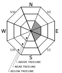
-
Likelihood ?CertainVery LikelyLikelyPossible
 Unlikely
 -
Size ?HistoricVery LargeLargeSmall

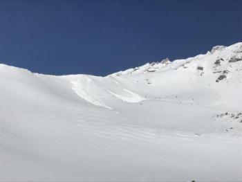
Natural and human triggered wind slabs are unlikely. Lingering wind slabs may still be found on SE-E-NE aspects above treeline. Avoid obviously wind-loaded unsupported slopes steeper than 35 degrees above 9,000ft on Mount Shasta. Continue to check for the presence of wind slabs by looking for cornices, blowing snow, wind pillows, and hollow sounding snow.
Forecast Discussion
Recent observations indicate wind slabs are becoming unreactive to triggers. Westerly winds have continued to hammer alpine terrain following last week’s storm. No longer are winds productively loading snow, only scouring exposed terrain features and eroding snow surfaces. Generally safe avalanche conditions exist in the backcountry.
Alpine rock features on Mount Shasta are covered with rime ice. As the warming trend continues today and through the week, icefall will be a significant hazard. Be especially careful in Avalanche Gulch below Casaval Ridge, the Trinity Chutes, and Redbanks.
Recent Observations
Skies were grey and cloudy yesterday. For more than 24 hours, temperatures have remained above freezing up to 8,000 ft. West/northwest winds battered the mountain averaging 20-30 mph with gusts over 50 mph at the Grey Butte weather station.
No avalanches or signs of instability have been observed since Saturday. Wind slabs are becoming hard to find. Snow surfaces are variable. Moist and heavy snow exists up to 8,000 ft, while above, breakable melt-freeze crusts, supportable wind crusts, wind-eroded features, and scoured icy surfaces can all be found.
Weather and Current Conditions
Weather Summary
A weak ridge of high pressure will build in the area today. Expect decreasing cloud cover throughout the day, westerly winds, and highs in the mid 40s at 6,000 ft. Tomorrow should be sunny with highs in the 50s. A few systems will move through the Pacific Northwest on Thursday, but northern California should remain dry. The long-term forecasts suggest our area will see above normal temperatures and below normal precipitation.
24 Hour Weather Station Data @ 6:00 AM
| Weather Station | Temp (°F) | Wind (mi/hr) | Snow (in) | Comments | ||||||||
|---|---|---|---|---|---|---|---|---|---|---|---|---|
| Cur | Min | Max | Avg | Avg | Max Gust | Dir | Depth | New | Water Equivalent | Settlement | ||
| Mt. Shasta City (3540 ft) | 32 | 32 | 62 | 43 | 0 | N | ||||||
| Sand Flat (6750 ft) | 42 | 33 | 43 | 38 | 25 | 0 | 0 | 0 | ||||
| Ski Bowl (7600 ft) | 39 | 38 | 48 | 43 | 45 | 0 | 0 | 0 | ||||
| Gray Butte (8000 ft) | 39 | 36 | 44 | 41 | 22 | 56 | WNW | |||||
| Castle Lake (5870 ft) | 43 | 41 | 57 | 47 | 12 | 0 | 1 | |||||
| Mount Eddy (6509 ft) | 41 | 40 | 50 | 45 | 3 | 16 | ESE | 26 | 0 | 1 | ||
| Ash Creek Bowl (7250 ft) | station down | |||||||||||
| Ash Creek Ridge (7895 ft) | station down |
Two Day Mountain Weather Forecast
Produced in partnership with the Medford NWS
| For 7000 ft to 9000 ft | |||
|---|---|---|---|
|
Tuesday (4 a.m. to 10 p.m.) |
Tuesday Night (10 p.m. to 4 a.m.) |
Wednesday (4 a.m. to 10 p.m.) |
|
| Weather | Mostly sunny | Partly cloudy | Mostly sunny |
| Temperature (°F) | 39 | 26 | 46 |
| Wind (mi/hr) | West/Northwest 10-15 mph | Northwest 10-15 mph | North/Northwest 10-15 mph |
| Precipitation SWE / Snowfall (in) | / 0 | / 0 | / 0 |
| For 9000 ft to 11000 ft | |||
| Tuesday | Tuesday Night | Wednesday | |
| Weather | Mostly sunny and windy | Partly cloudy and windy | Moslty sunny and windy |
| Temperature (°F) | 30 | 27 | 30 |
| Wind (mi/hr) | West 30-40 mph | West/Northwest 0 | Northwest 25-35 mph |
| Precipitation SWE / Snowfall (in) | / 0 | / 0 | / 0 |
Season Precipitation for Mount Shasta City
| Period | Measured (in) | Normal (in) | Percent of Normal (%) |
|---|---|---|---|
| From Oct 1, 2023 (the wet season) | 10.11 | 21.43 | 47 |
| Month to Date (since Apr 1, 2024) | 4.28 | 6.22 | 69 |
| Year to Date (since Jan 1, 2024) | 4.28 | 6.22 | 69 |

