

You are here
Avalanche Advisory for 2018-02-13 07:00
- EXPIRED ON February 14, 2018 @ 7:00 amPublished on February 13, 2018 @ 7:00 am
- Issued by Andrew Kiefer - Mt Shasta Avalanche Center
Bottom Line
Avalanche danger is LOW for all elevations. Avalanches are unlikely and NORMAL CAUTION is advised. Firm and icy snow surfaces are widespread. Shallow snowpack hazards exist. Icefall continues to be a concern above 10,000 ft on Mount Shasta.


Avalanche Problem 1: Normal Caution
-
Character ?

-
Aspect/Elevation ?
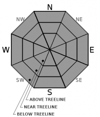
-
Likelihood ?CertainVery LikelyLikelyPossible
 Unlikely
 -
Size ?HistoricVery LargeLargeSmall

NORMAL CAUTION means:
- Watch for isolated slabs.
- Ski and ride one at a time in avalanche terrain.
- Don't regroup in run out zones.
- Basic avalanche rescue skills are essential in avalanche terrain.
Isolated slabs are related to wind and terrain. Look for places where small areas of drifting have occurred and firm layers of surface snow overlie softer layers. This will occur on the lee side of ridges, in terrain depressions, on convex terrain features, and in the lee of isolated bands of trees
Forecast Discussion
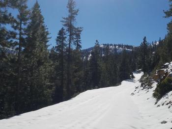
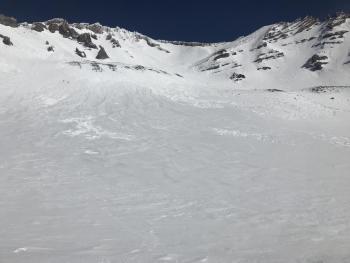
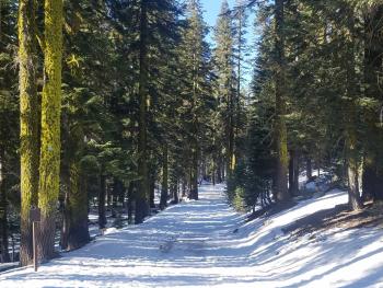
Castle Lake, Mount Eddy and the Ash Creek Butte areas all have very little or no snow. Above 6,500 ft on Mount Shasta remains the most useable snowpack for winter recreation in the advisory area. Overall, stability is very good and avalanche conditions are generally safe. Snow surfaces are firm and slick, and arresting a fall on a steep slope in these conditions would be difficult. Be sure to watch for rockfall and icefall in upper elevation terrain on Mount Shasta. LOW avalanche danger and normal caution will continue until a significant weather event occurs.
Recent Observations
Skies cleared late morning yesterday making for a sunny but cold day. High temperatures reached the upper 20s with overnight lows in the teens at 8,000 ft. East/northeast winds averaged 15-20 mph with gusts to 30 mph near treeline. Snow surfaces remained firm and very icy yesterday in the Old Ski Bowl. Raised tracks, rough wind-eroded features and slippery melt-freeze crusts made for less than ideal riding conditions. Coverage on the Everett Memorial highway above Bunny Flat is good. The snowpack is 1-4 ft deep above 7,000 ft, and is a consolidated mass comprised mostly of melt-freeze crusts and ice layers. No avalanches or evidence of unstable snow have been observed so far this month.
Weather and Current Conditions
Weather Summary
High pressure will bring clear and sunny weather today. Easterly winds will blow 10-15 mph with gusts to 35 mph above treeline, and high temperatures will reach the mid 40s. Tonight will be clear and cool with lows in the 20s. Tomorrow, a low-pressure ridge will drop into northern California bringing cool air and another light dusting of snow. Snow levels will be near 3,000 ft. Precipitation should occur between 4am-4pm Wednesday, and up to 1 inch of snow is possible.
24 Hour Weather Station Data @ 4:00 AM
| Weather Station | Temp (°F) | Wind (mi/hr) | Snow (in) | Comments | ||||||||
|---|---|---|---|---|---|---|---|---|---|---|---|---|
| Cur | Min | Max | Avg | Avg | Max Gust | Dir | Depth | New | Water Equivalent | Settlement | ||
| Mt. Shasta City (3540 ft) | 19 | 19 | 41 | 30 | 3 | ENE | ||||||
| Sand Flat (6750 ft) | 16 | 16 | 25 | 21 | 19 | 0 | 0 | 0 | ||||
| Ski Bowl (7600 ft) | 21.5 | 15 | 28.5 | 22.5 | 39.5 | 0 | 0 | .5 | ||||
| Gray Butte (8000 ft) | 23 | 14.5 | 25 | 20.5 | 12 | 31 | ENE | |||||
| Castle Lake (5870 ft) | 21 | 19 | 27.5 | 22.5 | 7.5 | 0 | .5 | |||||
| Mount Eddy (6509 ft) | 16.5 | 16 | 22 | 19 | 2 | 10 | WSW | 20 | 0 | 0 | ||
| Ash Creek Bowl (7250 ft) | station down | |||||||||||
| Ash Creek Ridge (7895 ft) | station down |
Two Day Mountain Weather Forecast
Produced in partnership with the Medford NWS
| For 7000 ft to 9000 ft | |||
|---|---|---|---|
|
Tuesday (4 a.m. to 10 p.m.) |
Tuesday Night (10 p.m. to 4 a.m.) |
Wednesday (4 a.m. to 10 p.m.) |
|
| Weather | Sunny | Mostly clear then 30% chance of snow. | 40% chance of snow in the morning then partly sunny. |
| Temperature (°F) | 30 | 23 | 24 |
| Wind (mi/hr) | SE 5-10 mi/hr | SE 5-10 mi/hr | SW 10-15 mi/hr |
| Precipitation SWE / Snowfall (in) | / 0 | / < .5 | / < 1 |
| For 9000 ft to 11000 ft | |||
| Tuesday | Tuesday Night | Wednesday | |
| Weather | Sunny and windy. Wind chill values as low as -10 degrees F. | Mostly clear then 30% chance of snow after 4am. | 40% chance of snow before 10am. Windy. Wind chill values as low as -12 degrees F. |
| Temperature (°F) | 26 | 21 | 26 |
| Wind (mi/hr) | E/NE 25-35 mi/hr | SW 0 | W/SW 30-40 mi/hr |
| Precipitation SWE / Snowfall (in) | / 0 | / < .5 | / < 1 |
Season Precipitation for Mount Shasta City
| Period | Measured (in) | Normal (in) | Percent of Normal (%) |
|---|---|---|---|
| From Oct 1, 2023 (the wet season) | 10.11 | 24.46 | 41 |
| Month to Date (since Apr 1, 2024) | 0.00 | 2.19 | 0 |
| Year to Date (since Jan 1, 2024) | 4.28 | 9.25 | 46 |

