

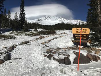
You are here
Avalanche Advisory for 2018-02-24 06:27
- EXPIRED ON February 25, 2018 @ 6:27 amPublished on February 24, 2018 @ 6:27 am
- Issued by Nick Meyers - Shasta-Trinity National Forest
Bottom Line
The avalanche danger is LOW. Firm and icy snow surfaces are widespread and shallow snowpack hazards exist. Fresh wind loading may occurr over the next 48 hours due to new snow and northwest winds. Pay attention to changing conditions. Watch for unstable snow on isolated terrain features.


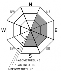
Avalanche Problem 1: Wind Slab
-
Character ?

-
Aspect/Elevation ?
-
Likelihood ?CertainVery LikelyLikelyPossible
 Unlikely
 -
Size ?HistoricVery LargeLargeSmall

A wind slab avalanche problem may be created by new snowfall and strong NW winds this weekend. Pay attention to changing conditions. Identify and avoid potentially unstable wind slab(s) by looking for fresh wind drifted snow. Further, watch for fragile cornices that can collapse under the weight of a person. Areas of snow surface cracking in near treeline and above treeline terrain are an additional indication of unstable snow.
- Ski and ride one at a time in avalanche terrain.
- Don't regroup in run out zones.
- Avalanche rescue skills are essential in avalanche terrain.
Forecast Discussion
Northwest winds have stripped the mountain down to old snow surfaces. Leeward convavities hold 3 to 15 inches of firm, chalky, wind-packed powder. Old snow surfaces are icy, firm and gnarly. Of greatest concern will be new, active wind loading that may occur during the storms forecasted for this weekend.
Recent Observations
- Below treeline, 3 to 4 inches of low density snow sits on top of our existing, rock-hard snow surface. Bare ground is exposed in many areas, as well as exposed rocks, chaparral and other forest products. No instability has been observed
- Near treeline is transitional. From 7,500 feet to 8,500 feet, gusty northwest winds became noticeable. All avalanche starting zones observed were scoured down to rock and/or the old snow surface.
- Recent storm snow has been stripped away and blown into leeward south and southeast facing depressions, gullies and concavities.
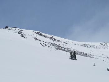
- Above treeline, northwest winds howled and have scoured all steep, avalanche prone slopes. Only the old snow surface remains and it is icy, firm and glazed over in most areas.
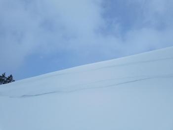
- Wind slabs were observed on low angle (15-25 deg), S/SE aspects. Several extended column tests produced very easy, sudden collapse, full propagation fractures below a pencil hard 20cm slab sitting on top of weaker snow layers. This was notable, however I could not find any wind slabs on steeper slopes.
- Leeward snow deposits measured 3 to 15 inches
- Overall, the majority of the mountain is stripped down to the old snow surface and signs of avalanche danger was hard to come by.
Weather and Current Conditions
Weather Summary
Two rounds of snow showers will move over the area this weekend. Models suggest .04 inches of snow/water equivalent today and .17 inches tomorrow afternoon. Surely, this is better than nothing and we can expect a couple inches of fresh snow out of each storm system. Snow levels remain at town, or lower. Most notable for the next couple days are gale force winds that will most likely keep the mountain scoured and icy near and above treeline. Northwest flow ushers in 40-50 mi/hr wind speeds this weekend for exposed areas on the mountain. We will see a break early next week and then a more noteworthy system should line up for late Wednesday. Northerly flow will shift to westerly and then southwesterly and it looks to be a big snow producer. We sure hope so.
24 Hour Weather Station Data @ 5:00 AM
| Weather Station | Temp (°F) | Wind (mi/hr) | Snow (in) | Comments | ||||||||
|---|---|---|---|---|---|---|---|---|---|---|---|---|
| Cur | Min | Max | Avg | Avg | Max Gust | Dir | Depth | New | Water Equivalent | Settlement | ||
| Mt. Shasta City (3540 ft) | 28 | 19 | 42 | 32 | 3 | |||||||
| Sand Flat (6750 ft) | station down | |||||||||||
| Ski Bowl (7600 ft) | 20 | 2 | 25 | 18 | 43.5 | 0 | 0 | 0 | ||||
| Gray Butte (8000 ft) | 17 | 3 | 20.5 | 14.5 | 10 | 43 | SE | |||||
| Castle Lake (5870 ft) | 22.5 | 9 | 25.5 | 20 | 9.5 | 0 | .5 | |||||
| Mount Eddy (6509 ft) | 17.5 | 6 | 25 | 18.5 | 2 | 10 | SE | 24.5 | 0 | .5 | ||
| Ash Creek Bowl (7250 ft) | station down | |||||||||||
| Ash Creek Ridge (7895 ft) | station down |
Two Day Mountain Weather Forecast
Produced in partnership with the Medford NWS
| For 7000 ft to 9000 ft | |||
|---|---|---|---|
|
Saturday (4 a.m. to 10 p.m.) |
Saturday Night (10 p.m. to 4 a.m.) |
Sunday (4 a.m. to 10 p.m.) |
|
| Weather | Snow showers likely, windy. | Mostly cloudy, windy. | Snow likely after 4pm, breezy. |
| Temperature (°F) | 28 | 20 | 32 |
| Wind (mi/hr) | W 10-15 mi/hr | NW 10-15 mi/hr | W 10-15 mi/hr |
| Precipitation SWE / Snowfall (in) | / 1-2 | / 0 | / 1-2 |
| For 9000 ft to 11000 ft | |||
| Saturday | Saturday Night | Sunday | |
| Weather | Snow showers likely, windy. | Mostly cloudy, windy | Snow likely after 4pm, windy |
| Temperature (°F) | 13 | 13 | 15 |
| Wind (mi/hr) | NW 40-50 mi/hr | NW 1-2 | NW 30-40 mi/hr |
| Precipitation SWE / Snowfall (in) | / 1-2 | / 0 | / 1-2 |
Season Precipitation for Mount Shasta City
| Period | Measured (in) | Normal (in) | Percent of Normal (%) |
|---|---|---|---|
| From Oct 1, 2023 (the wet season) | 10.27 | 28.14 | 36 |
| Month to Date (since Apr 1, 2024) | 0.16 | 5.87 | 3 |
| Year to Date (since Jan 1, 2024) | 4.44 | 12.93 | 34 |

