

You are here
Avalanche Advisory for 2018-03-31 05:37
- EXPIRED ON April 1, 2018 @ 5:37 amPublished on March 31, 2018 @ 5:37 am
- Issued by Nick Meyers - Shasta-Trinity National Forest
Bottom Line
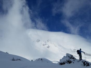
The avalanche danger is LOW at all elevations and aspects. Exercise normal caution. Watch for small, isolated wind slabs above treeline and loose wet activity near and below treeline. Be wary of falling rime ice on the upper mountain.


Avalanche Problem 1: Normal Caution
-
Character ?

-
Likelihood ?CertainVery LikelyLikelyPossible
 Unlikely
 -
Size ?HistoricVery LargeLargeSmall

Generally safe avalanche conditions exist in the backcountry. LOW avalanche danger does not mean NO avalanche danger:
- Watch for small isolated wind slabs where areas of drifting have occurred and firm layers of surface snow overlie softer layers.
- Warm weather and solar radiation can cause loose wet avalanches. To avoid, travel when the snow surface is colder and stronger. Plan your trips to avoid crossing on or under very steep sunlit slopes.
- Small cornices exist on easterly aspects. Increasing temperatures may weaken these causing them to fall. Avoid traveling on top or below them.
Forecast Discussion
Spring is the time of year when anything is possible: Warm, sunny days can be immediately followed by winter-like conditions: snow and avalanche danger, extreme wind, whiteout, cold temperatures. Climbing season is upon us. Plan and prepare properly. Every year, climbers become lost, injured or killed on Mount Shasta. While not an extremely difficult mountain, it still has real hazards. Don't get "casual day syndrome". Be honest with your skills and abilities. One poor decision can often snowball into a bad situation. Have fun, with safety in mind.
Temperatures will drop several degrees over the next couple days and winds will increase. This will keep loose wet snow instabilities at bay.
Recent Observations
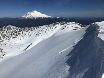
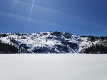
Yesterday, high temperatures climbed to 55 deg F at treeline on Mount Shasta. In town, temps topped out at 70 degrees F. Winds have remained calm out of the W/NW. The several feet of snow from our late March storm(s) still continues its melt/freeze transition. Conditions yesterday in Avalanche Gulch were variable: icy ridge lines, some dryer wind effected snow and areas of melt/freeze, corn snow were encountered. Loose wet snow instabilities were far and few between. A thin layer of high cirrostratus clouds covered the sky for most of the day. Bunny Flat still holds a couple feet of snow. The Pilgrim Creek Sno-Park is likely compromised due to lack of snow. The Sand Flat cross-country ski trails are still fair game and in decent shape. Castle Lake area is marginal... a barely usable snowpack will allow for a few turns. The Eddy Mountains hold 3 to 4 feet of snow and a usable snowpack is available for skiers, but not really for snow machines.
Weather and Current Conditions
Weather Summary
An upper level short wave will swing through the area today. This could cause a bit more cloudiness, but overall, it will be another mild, spring day with temperatures just slightly lower than yesterday. Above treeline on the mountain, it may be a little breezy from the N/NW late this afternoon. A disturbance will dig southeastward Sunday and Monday. Easter will be dry here, albeit several degrees cooler. Drier air with high pressure moves in Monday afternoon with increasing sunshine. Models continue to be in agreement on an onshore flow with an active pattern of weak to moderate fronts for the second half of next week. Timing of these TBD! Have a great weekend.
24 Hour Weather Station Data @ 4:00 AM
| Weather Station | Temp (°F) | Wind (mi/hr) | Snow (in) | Comments | ||||||||
|---|---|---|---|---|---|---|---|---|---|---|---|---|
| Cur | Min | Max | Avg | Avg | Max Gust | Dir | Depth | New | Water Equivalent | Settlement | ||
| Mt. Shasta City (3540 ft) | 38 | 38 | 70 | 52.5 | 2 | N | ||||||
| Sand Flat (6750 ft) | station down | |||||||||||
| Ski Bowl (7600 ft) | 41.5 | 39 | 55.5 | 45 | 79.1 | 0 | 0 | 2.3 | ||||
| Gray Butte (8000 ft) | 41 | 41 | 52.5 | 44.5 | 7 | 18 | WNW | |||||
| Castle Lake (5870 ft) | 0 | 0 | 0 | 0 | 0 | 0 | 0 | station down | ||||
| Mount Eddy (6509 ft) | 37.5 | 37 | 54 | 45 | 2 | 7 | WSW | 43.7 | 0 | 2.5 | ||
| Ash Creek Bowl (7250 ft) | station down | |||||||||||
| Ash Creek Ridge (7895 ft) | station down |
Two Day Mountain Weather Forecast
Produced in partnership with the Medford NWS
| For 7000 ft to 9000 ft | |||
|---|---|---|---|
|
Saturday (4 a.m. to 10 p.m.) |
Saturday Night (10 p.m. to 4 a.m.) |
Sunday (4 a.m. to 10 p.m.) |
|
| Weather | Cloudy this morning, then clearing | Mostly clear | Sunny, then becoming partly cloudy |
| Temperature (°F) | 52 | 33 | 48 |
| Wind (mi/hr) | NW 0-5 mi/hr | NW 0-5 mi/hr | NW 0-5 mi/hr |
| Precipitation SWE / Snowfall (in) | / 0 | / 0 | / 0 |
| For 9000 ft to 11000 ft | |||
| Saturday | Saturday Night | Sunday | |
| Weather | Cloudy this morning then clearing, breezy | Mostly clear | Sunny and windy, becoming partly cloudy |
| Temperature (°F) | 31 | 30 | 30 |
| Wind (mi/hr) | W 15-20 mi/hr | W 0 | W 15-20 mi/hr |
| Precipitation SWE / Snowfall (in) | / 0 | / 0 | / 0 |
Season Precipitation for Mount Shasta City
| Period | Measured (in) | Normal (in) | Percent of Normal (%) |
|---|---|---|---|
| From Oct 1, 2023 (the wet season) | 15.95 | 35.33 | 45 |
| Month to Date (since Apr 1, 2024) | 5.06 | 5.83 | 87 |
| Year to Date (since Jan 1, 2024) | 10.12 | 20.12 | 50 |

