

You are here
Avalanche Advisory for 2018-04-11 06:31
- EXPIRED ON April 12, 2018 @ 6:31 amPublished on April 11, 2018 @ 6:31 am
- Issued by Aaron Beverly - Mount Shasta Avalanche Center
Bottom Line
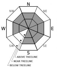
Over a foot of snow is possible in the next 24 hours. Existing smooth firm snow could provide ideal bed surfaces for wind slab and loose dry avalanches. Avalanche danger will rise to CONSIDERABLE above treeline and MODERATE near and below treeline. Evaluate snow and terrain carefully today. Human triggered avalanches are likely and natural avalanches are possible.


Avalanche Problem 1: Wind Slab
-
Character ?

-
Aspect/Elevation ?
-
Likelihood ?CertainVery LikelyLikelyPossible
 Unlikely
 -
Size ?HistoricVery LargeLargeSmall

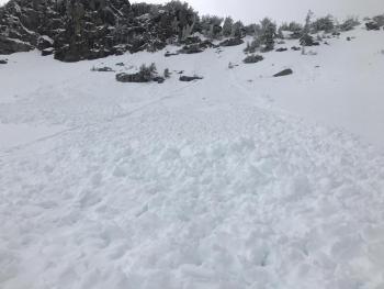
Upper elevations could see over a foot of snow over the next 24 hours. This coupled with strong SW and W winds will contribute to the development of wind slabs that could be over 2 feet thick. Though some snow was received yesterday, smooth icy snow surfaces are still likely to exist which will provide ideal bed surfaces for today's snow. Expect CONSIDERABLE avalanche danger above treeline and MODERATE near treeline. CONSIDERABLE means human triggered avalanches are likely and natural avalanches are possible.
Evaluate snow and terrain carefully today. Avoid wind slabs by traveling in windward areas where snow surfaces have been eroded. Avoid slopes greater than 35 degrees where wind loading has occurred. Evaluate conditions as you travel in safe terrain by looking for signs of the wind slab problem:
- Smooth rounded wind pillows
- Hollow sounding snow
- Harder snow atop softer snow
- Shooting cracks
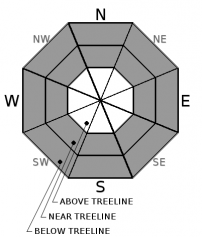
Avalanche Problem 2: Loose Dry
-
Character ?

-
Aspect/Elevation ?
-
Likelihood ?CertainVery LikelyLikelyPossible
Unlikely
-
Size ?HistoricVery LargeLargeSmall
New dry snow atop smooth firm bed surfaces may present a loose dry problem today and tonight. Also called sluffs, loose dry avalanches start at a point and entrain snow as they move downhill, forming a fan-shaped avalanche. Though usually harmless, they could carry an unsuspecting skier into undesirable terrain. Be prepared for this problem on slopes greater than 35 degrees in areas unaffected by the wind.
Forecast Discussion
The inch of wet snow received yesterday below 8000 ft may have already frozen into a crust. Widespread smooth icy snow surfaces existing from Tuesday are likely to be exposed in places at higher elevations. These smooth firm conditions provide ideal bed surfaces for avalanches. Cold conditions today may prevent new snow from bonding well to the old snow. Evaluate this interface carefully today if traveling in the backcountry. Ski cuts around tree wells and on inconsequential rollovers are a great way to test the snowpack.
The cold front moving in today will bring unusually cold temperatures on the upper mountain. Be prepared for -20 °F wind chills and low visibility above treeline.
Recent Observations
The Old Ski Bowl weather station received 0.25 inches of water and about 1 inch of wet snow. Light winds (10-15 mi/hr) blew from the SW and W. Above treeline snow accumulation could not be verified. Temperatures at 8000 ft remained near or above freezing until 10 p.m. last night.
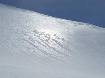
On Tuesday, smooth icy snow surfaces existed on all aspects and at all elevations. Grapefruit sized balls of ice were seen in gullies below Helen Lake and ice fall was active out of Red Banks and the Trinity Chutes.
Weather and Current Conditions
Weather Summary
Snow levels will drop from 5100 ft today down to town tonight as a cold front moves through the area. By tomorrow morning, expect 9-15 inches of snow above treeline and 5-10 below. The most intense snowfall is expected tonight. Temperatures will drop into the single digits tonight with wind chills reaching -20 °F. Winds will transition from S/SW to W. Below treeline winds look to be light to moderate (10-20 mi/hr), while above treeline winds will be strong (30-45 mi/hr).
Showery weather will continue after the front bringing up to another inch of snow tomorrow. Cold unstable weather is expected to continue into next week.
24 Hour Weather Station Data @ 5:00 AM
| Weather Station | Temp (°F) | Wind (mi/hr) | Snow (in) | Comments | ||||||||
|---|---|---|---|---|---|---|---|---|---|---|---|---|
| Cur | Min | Max | Avg | Avg | Max Gust | Dir | Depth | New | Water Equivalent | Settlement | ||
| Mt. Shasta City (3540 ft) | 45 | 34 | 56 | 47.5 | 2 | N | ||||||
| Sand Flat (6750 ft) | station down | |||||||||||
| Ski Bowl (7600 ft) | 28 | 27.5 | 36 | 32 | 74 | 1 | 0.25 | 1 | ||||
| Gray Butte (8000 ft) | 27 | 24.5 | 35 | 31 | 13 | 37 | WSW | |||||
| Castle Lake (5870 ft) | station down | |||||||||||
| Mount Eddy (6509 ft) | 30.5 | 30.5 | 42 | 35 | 2 | 12 | S | 37 | 0.5 | 0.5 | ||
| Ash Creek Bowl (7250 ft) | station down | |||||||||||
| Ash Creek Ridge (7895 ft) | station down |
Two Day Mountain Weather Forecast
Produced in partnership with the Medford NWS
| For 7000 ft to 9000 ft | |||
|---|---|---|---|
|
Wednesday (4 a.m. to 10 p.m.) |
Wednesday Night (10 p.m. to 4 a.m.) |
Thursday (4 a.m. to 10 p.m.) |
|
| Weather | Snow. Breezy. Chance of precipitation is 100%. | Snow. Chance of precipitation is 100%. | Snow showers, mainly after 11 a.m. Chance of precipitation is 80%. |
| Temperature (°F) | 29 | 20 | 29 |
| Wind (mi/hr) | S 15-20 | W 10-15 | W 10-15 |
| Precipitation SWE / Snowfall (in) | / 2-4 | / 3-6 | / 1 |
| For 9000 ft to 11000 ft | |||
| Wednesday | Wednesday Night | Thursday | |
| Weather | Snow. Wind chill values as low as 1. Windy. Chance of precipitation is 100%. | Snow. Wind chill values as low as -20. Windy. Chance of precipitation is 100%. | Snow showers likely, mainly after 11 a.m. Mostly cloudy. Wind chill values as low as -14. Windy. Chance of precipitation is 70%. |
| Temperature (°F) | 22 | 5 | 10 |
| Wind (mi/hr) | SW 40-45 | W 3-6 | W 30-35 |
| Precipitation SWE / Snowfall (in) | / 3-6 | / 6-9 | / 1 |
Season Precipitation for Mount Shasta City
| Period | Measured (in) | Normal (in) | Percent of Normal (%) |
|---|---|---|---|
| From Oct 1, 2023 (the wet season) | 17.25 | 36.58 | 47 |
| Month to Date (since Apr 1, 2024) | 1.30 | 1.12 | 116 |
| Year to Date (since Jan 1, 2024) | 11.42 | 21.37 | 53 |

