You are here
Avalanche Advisory for 2016-03-20 06:59:55
- EXPIRED ON March 21, 2016 @ 6:59 amPublished on March 20, 2016 @ 6:59 am
- Issued by Nick Meyers - Shasta-Trinity National Forest
Bottom Line
Overall, LOW avalanche danger exists for all elevations and aspects this morning and will prevail below treeline all day.
Late in the day, high snow levels will create new wind and storm slabs near and above treeline and MODERATE with pockets of CONSIDERABLE danger are possible on wind loaded, leeward NW-N-NE-E facing slopes.
Expect windy southwesterly flow, ample precipitation (.7" today) and snow levels >7,000 feet to cause the avalanche danger to rise over the next several days. Use caution!
Avalanche Problem 1: Wind Slab
-
Character ?

-
Aspect/Elevation ?

-
Likelihood ?CertainVery LikelyLikelyPossible
 Unlikely
 -
Size ?HistoricVery LargeLargeSmall

This morning the avalanche danger is LOW across the forecast area. As the storm moves over the region, the danger will increase. South/southwest winds will blow 40-50 mph at mid-mountain levels and load leeward NW-N-NE-E facing slopes. While areas below approximately 7,500 feet will received rain on snow, elevations above will get all snow. Pair snow with wind and you certainly have a recipe for an avalanche. If you find yourself up on the mountain for an afternoon jaunt, be cautious of newly formed wind slabs on leeward aspects near ridgelines. Wind slabs could be small to medium in size. I suspect they will bond well to the old snow surface due to the warm nature of this storm and old snow surface, however the higher you go in elevation, the more unstable they could be. The most unstable wind slabs will likely occur tomorrow and Tuesday, but today you should start to elevate your terrain management choices and situational awareness!
Avalanche Problem 2: Storm Slab
-
Character ?

-
Aspect/Elevation ?

-
Likelihood ?CertainVery LikelyLikelyPossible
 Unlikely
 -
Size ?HistoricVery LargeLargeSmall

The chance of triggering a storm slab is low for most of the day. Near and just above treeline, later in the day and as new storm snow piles up, a small to medium sized storm slab is possible. As we've seen this year, the best storm slab formation has been right near treeline. Sparse trees, partially protected areas yet still open and uniform slopes have been prime storm slab producers. Above treeline, wind will likely keep storm slabs at bay. Tomorrow will present the best chance of storm slab formation and trigger.
Forecast Discussion
A couple decent looking little storms brewing this morning that will give the Mt Shasta area about an inch and a half of water by Tuesday. Gusty southwest flow will bring high winds to the upper mountain. Cold air moves in behind the precipitation.... this will lower snow levels of course, but we'll see rain on snow and high snow levels for a good part of today first. Here are the stats: Today, snow levels upwards of 7 to 8,000 feet with .7 inches of water expected, gusty south/southwest winds. As temperatures cool today, we'll see the snow level gradually fall by the afternoon and snow levels should reach the 5,000 foot level by tonight. Precip will taper off a bit tonight also, but pick back up for a second round on Monday. This second round will host up to .9 inches of water, gusty south/southwest winds again and snow levels down to 4-4,500 feet. Areas that recieve all snow (near/above treeline, Mt Shasta) could see a foot or more of new snow where as lower elevation areas may get up to a foot of fresh snow by Tuesday. So, nothing to shake a stick at. While a bit warm now, things should cool off and we'll get a nice refresh to the snowpack. This will also cause the avalanche danger to rise, so don't put on your Spring blinders yet. Pay attention to the terrain you choose out there in the backcountry!
THIS SEASON PRECIPITATION for MT SHASTA CITY: Since October 1st (the wet season), we have received 35.35 inches of water, normal is 33.72 inches, putting us at 104% of normal. For the month of March we've received 9.83 inches of water, normal is 4.22 inches, putting us at 232% of normal, and finally... for the year of 2016 we've received 25.86 inches of water, normal is 18.51 inches, putting us at 139% of normal.
Recent Observations
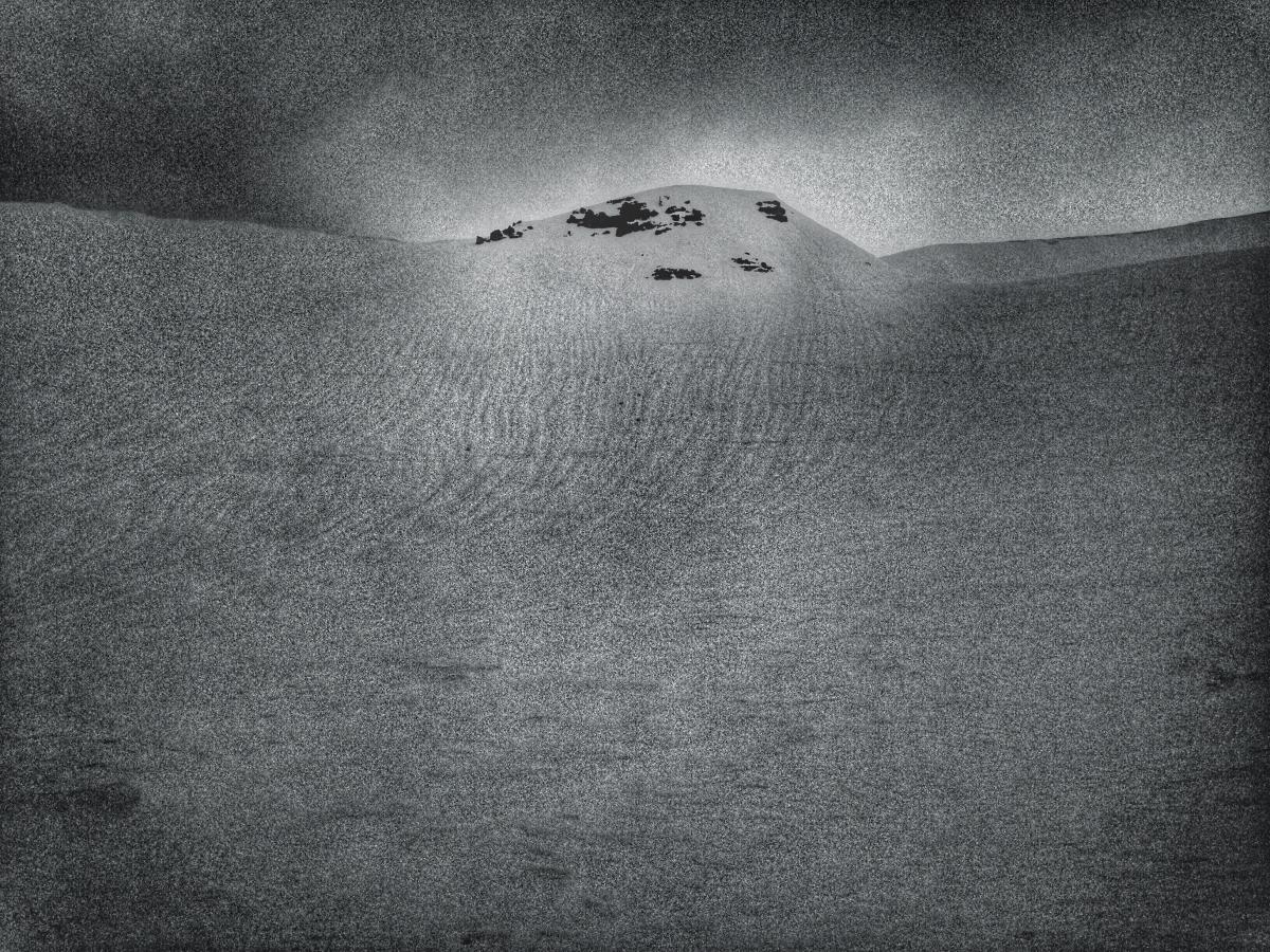
The weekend's storm started to blow in yesterday as a ski tour up the south side of the mountain gave way to increasing clouds throughout the day and a cloud deck at about 9,000 to 10,000 feet. Some very light precip at times (rain) blew through but it all was a bit of a fake out as the day ended up being mostly cloudy with out any real storm action. The snow continues to settle several inches a day with another 3-5 inches of settlement recorded at weather stations in the past 24 hours. Several nights of poor re-freeze have given us an all melt, no freeze snowpack below 8,500 feet or so. Further, the consistently warm, or should I say HOT temps this week really did a number to the 4 feet of fresh. Runnels in the snowpack are widespread over the forecast area. Runnels are formed by liquid water in the snowpack giving way to gravity, finding that path of least resistance and creating water channels in the snowpack, visible on the snowpack surface. The light was horrible yesterday, but with a little photo editing, I tried to capture the snow surface conditions in a photo below. Terrain above 8,500 feet hosted decent skiing where smoother sections of snow existed. Many aspects, even above 8,500 feet, held runnels and varible snow. Varible was really the best way to descibe things... Soft, sticky stuff, harder wind packed sastrugi, icy old crusts, melt/poor freeze... you name it, we've got it. That will all change with the incoming storm.
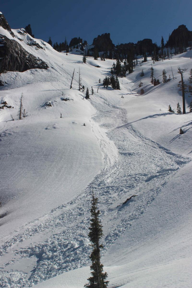
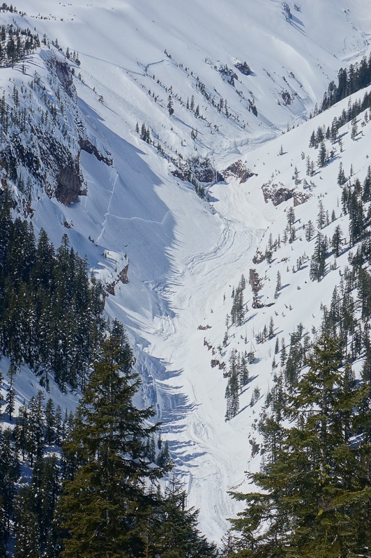
Speaking snow stability, yesterday had enough cloud cover and wind that loose-wet instabilities were none and wind slabs are well bonded to the old snow. Snowpit tests have not indicated any current issues within the snowpack. Local observations continue to come in over the week reporting recent avalanche activity however. A wet loose slide was naturally triggered in the Castle Spire area (observed 3/18) and a large slab avalanche was observed (3/17) in Mud Creek Canyon, both occuring sometime over the past week.
A note for all climbers and skiers heading up onto the upper mountain: Rime ice has formed on most rock outcroppings and is currently very thick. As warm days ensue, rime ice will flake off and fall down onto the slopes below. Rime ice chunks can be very large and very hard, enough to potentially kill you or cause serious injury. Beware of this hazard.


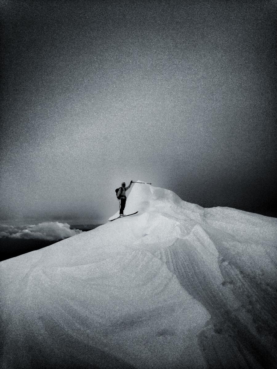
LEFT: Wild, wind sculpted snow on top of Green Butte, South side, Mt Shasta on 3.19.16. WInd features like this can be found throughout the forecast area. RIGHT: Widespread melt runnels, 3.19.16


LEFT: Loose-wet slide observed under Castle Spire, Castle Lake area on 3.18.16, photo: O. Stroud - RIGHT: Slab avalanche in Mud Creek Canyon observed 3.17.16, photo: G. Kallio
-----------------------------------------------------------------------------------------------------------------------------------------------------------
LOCAL AREA ROAD, NORDIC, AND SNOWMOBILE PARK STATUS:
The Sand Flat cross country ski trails are in good shape and ready for your cross country skis and snow shoes. These are backcountry routes marked with blue diamonds on trees. Trails are not groomed. Snow shoers, please blaze a parallel trail to cross country skiers staying out of the skin track. These trails can be accessed via the Everett Memorial Highway. Thank you, and enjoy!
The Mt. Shasta Nordic Center is open! These beautiful, groomed trails can be accessed via the Ski Park Highway. http://www.mtshastanordic.org
The Pilgrim Creek & Deer Mountain Snowmobile Parks are open! Trails have not been groomed in the past week and a half due to constant deep snow fall. Head to our "Education" tab on our website and find the snowmobile section for trail information, grooming status, and other sledder resources.
The Castle Lake Road is OPEN. The Everett Memorial Highway is plowed to Bunny Flat and currently mostly snow free until about Red Fir Flat up.
The Five Red Flags of Avalanche Danger any time of year include: 1) Recent/current avalanche activity 2) Whumphing sounds or shooting cracks 3) Recent/current heavy snowfall 4) Strong winds transporting snow 5) Rapid warming or rain on snow.
Weather and Current Conditions
Weather Summary
Good Morning! In Mt Shasta City at 0500, we have a current temperature of 50 F, 5 degrees warmer than yesterday at this time. Skies are obscured with a breezy wind and light rain.
On Mt Shasta (South Side) in the last 24 hours...
Old Ski Bowl - 7,600 feet, the current temperature is 35 degrees F. Snow on the ground totals 157 inches with no new snow and 4 inches of settlement. Temperatures have ranged from 35 F to 44 F.
Gray Butte - 8,000 feet, the current temperature is 34 degrees F. Temperatures have ranged from 34 F to 40 F. Winds were west/northwesterly early yesterday, switched to southeast and have been southwest most recently, averaging 10 mph with a couple gusts to 28 mph out of the south.
Mt Eddy Range (West side of Interstate-5)...
Castle Lake - 5,600 feet, the current temperature is 38 degrees F. Temperatures have ranged from 38 F to 54 F. Snow on the ground totals 73 inches with no new snow and 5 inches of settlement.
Mt Eddy - 6,500 feet, the current temperature is 38 degrees F. Temperatures have ranged from 36 F to 46 F. Snow on the ground measures 87 inches with no new snow and 3.5 inches of settlement. Winds have been southerly in nature with an average of 2 mph, and a maximum gust of 14 mph, SSW.
Always check the weather before you attempt to climb Mt Shasta. Further, monitor the weather as you climb. Becoming caught on the mountain in any type of weather can compromise life and limb. Be prepared.
| 0600 temperature: | 38 |
| Max. temperature in the last 24 hours: | 48 |
| Average wind direction during the last 24 hours: | WNW->SE->S/SW |
| Average wind speed during the last 24 hours: | 10 mi/hr |
| Maximum wind gust in the last 24 hours: | 28 (Gray Butte) mi/hr |
| New snowfall in the last 24 hours: | 0 inches |
| Total snow depth: | 101 inches |
Two Day Mountain Weather Forecast
Produced in partnership with the Medford NWS
| For 7000 ft to 9000 ft | |||
|---|---|---|---|
|
Sunday (4 a.m. to 10 p.m.) |
Sunday Night (10 p.m. to 4 a.m.) |
Monday (4 a.m. to 10 p.m.) |
|
| Weather | Rain showers before 11am, then rain and snow showers. High near 41. Windy, with a south southeast wind 15 to 25 mph, with gusts higher. Chance of precipitation is 100%. Little or no snow accumulation expected. | Snow showers. Low around 28. Windy, with a south wind 15-25 mph, with gusts higher. Chance of precipitation is 90%. New snow accumulation of 2 to 4 inches possible. | Snow showers. High near 32. Breezy, with a south wind 20 to 30 mph, with gusts higher. Chance of precipitation is 100%. New snow accumulation of 8 to 12 inches possible. |
| Temperature (°F) | 41 | 28 | 32 |
| Wind (mi/hr) | South/Southeast 15-25 mph with gusts higher | South 15-25 mph with gusts higher | South 20-30 mph with gusts higher |
| Precipitation SWE / Snowfall (in) | / 0-.5 | / 2-4 | / 8-12 |
| For 9000 ft to 11000 ft | |||
| Sunday | Sunday Night | Monday | |
| Weather | Snow, mainly before 11am, then snow showers after 11am. The snow could be heavy at times. Temperature falling to around 22 by 4pm. Wind chill values as low as -4. Windy, with a south southwest wind, 40-50 mph with gusts higher in exposed terrain. Chance of precipitation is 100%. New snow accumulation of 8 to 12 inches possible. | Snow showers. Low around 15. Wind chill values as low as -10. Windy, with a south southwest wind 40-50 mph with gusts higher in exposed terrain. Chance of precipitation is 90%. New snow accumulation of 3 to 7 inches possible. | Snow showers. The snow could be heavy at times. High near 17. Wind chill values as low as -10. Windy, with a south southwest wind 40-50 mph, decreasing. Chance of precipitation is 100%. New snow accumulation of 13 to 19 inches possible. |
| Temperature (°F) | 22 | 15 | 17 |
| Wind (mi/hr) | South/southwest 40-50 mph | South/Southwest 8-12 | South/southwest 40-50 mph |
| Precipitation SWE / Snowfall (in) | / 8-12 | / 3-7 | / 13-19 |


