You are here
Avalanche Advisory for 2018-01-18 06:38:01
- EXPIRED ON January 19, 2018 @ 6:38 amPublished on January 18, 2018 @ 6:38 am
- Issued by Nick Meyers - Shasta-Trinity National Forest
Bottom Line
A winter storm will impact the area over the next 36 hours. The avalanche danger is LOW this morning, but will rise to MODERATE this afternoon as new snow and wind create fresh wind slabs near and above treeline on Mount Shasta. Pay attention to changing conditions today. Below treeline, LOW avalanche danger will continue.
Avalanche Problem 1: Wind Slab
-
Character ?

-
Aspect/Elevation ?

-
Likelihood ?CertainVery LikelyLikelyPossible
 Unlikely
 -
Size ?HistoricVery LargeLargeSmall

Remember, most of our avalanche danger occurs immediately during or just after storm cycles. Southwesterly flow will create new wind slabs on primarily N-NE-E-SE aspects near and above treeline. LOW danger this morning will likely rise to MODERATE by this afternoon/evening.
Look for wind slabs is areas such as:
- Near the tops of ridges
- Rollovers above steep terrain
- On N-NE-E-SE aspects
- Near & above treeline
Forecast Discussion
Precipitation has started falling as of 0400 hours this morning. This first storm will begin warm and quickly cool. This setup usually "pastes" new snow onto old snow well. At upper elevations, the situation could be different. It will be important to monitor changing conditions as one gains elevation today. Falling rime ice and firm icy conditions remain a concern above treeline. Naturally, bring an ice axe, crampons and helmet for any steep slope adventures.
Recent Observations
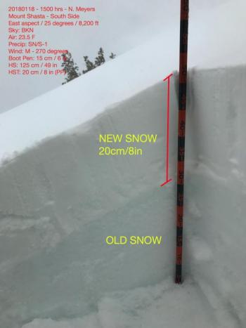
No significant change was observed yesterday. The mountain experienced a cloudy day with highs in the upper 30's to low 40's F. Winds averaged 15 mph out of the southwest with no precipitation. Two to three inches of new snow Monday night freshened up the snowpack above 7000 ft. The height of new snow showed little variation with elevations up to 11,000 ft. Snow surfaces are a mix of wind drifts, firm icy crusts, and wind eroded features. Fallen rime ice was encountered above 10,000 ft in Avalanche Gulch.
Weather and Current Conditions
Weather Summary
The next couple days will feel as wintery as Mount Shasta has felt all season. Precipitation is filling in and the approaching cold front pushes on shore this morning. Upwards of .82 inches of SWE (Snow-Water Equivalent) will fall today. Snow levels will start near 6,500 ft and lower to 4,500 ft by this evening. Southerly winds will crank near and above treeline. This system will bring lingering showers through Friday. Saturday we'll see a break and Sunday another blast of weather should commence.
Always check the weather before you attempt to climb Mt Shasta. Further, monitor the weather as you climb. Becoming caught on the mountain in any type of weather can compromise life and limb. Be prepared.
24 Hour Weather Station Data @ 4:00 AM
| Weather Station | Temp (°F) | Wind (mi/hr) | Snow (in) | Comments | ||||||||
|---|---|---|---|---|---|---|---|---|---|---|---|---|
| Cur | Min | Max | Avg | Avg | Max Gust | Dir | Depth | New | Water Equivalent | Settlement | ||
| Mt. Shasta City (3540 ft) | 43 | 43 | 51 | 48 | 4 | ESE | ||||||
| Sand Flat (6750 ft) | 34 | 33 | 42 | 36 | 11 | 0 | 0 | 1 | ||||
| Ski Bowl (7600 ft) | 31 | 31 | 41 | 35 | 24 | 0 | 0 | 2 | ||||
| Gray Butte (8000 ft) | 29 | 29 | 37 | 33 | 14 | 43 | WSW | |||||
| Castle Lake (5870 ft) | 33 | 33 | 40 | 37 | 0 | 0 | 0 | |||||
| Mount Eddy (6509 ft) | 32 | 32 | 40 | 36 | 2 | 14 | SSW | 9 | 0 | 0 | ||
| Ash Creek Bowl (7250 ft) | Station down | |||||||||||
| Ash Creek Ridge (7895 ft) | Station down |
Two Day Mountain Weather Forecast
Produced in partnership with the Medford NWS
| For 7000 ft to 9000 ft | |||
|---|---|---|---|
|
Thursday (4 a.m. to 10 p.m.) |
Thursday Night (10 p.m. to 4 a.m.) |
Friday (4 a.m. to 10 p.m.) |
|
| Weather | Rain and snow showers, becoming all snow after 10am. Temperatures falling. Windy. Snow level near 6,500 ft | Snow showers. Snow level near 4,300 ft | Snow showers, snow level near 1,500 ft |
| Temperature (°F) | 36 | 22 | 28 |
| Wind (mi/hr) | South 10-20 mph | Southwest 5-15 mph | South 5-10 mph |
| Precipitation SWE / Snowfall (in) | / 2-3 | / 2-3 | / 1-2 |
| For 9000 ft to 11000 ft | |||
| Thursday | Thursday Night | Friday | |
| Weather | Snow before 10am, then snow showers. Temperatures falling. Windy. | Snow showers, windy. | Snow showers likely, cloudy and cold, windy. |
| Temperature (°F) | 26 | 7 | 8 |
| Wind (mi/hr) | Southwest 40-50 mph | Southwest 4-6 | West 20-30 mph |
| Precipitation SWE / Snowfall (in) | / 4-6 | / 2-4 | / 1-3 |
Season Precipitation for Mount Shasta City
| Period | Measured (in) | Normal (in) | Percent of Normal (%) |
|---|---|---|---|
| From Oct 1, 2024 (the wet season) | 8.03 | 19.26 | 42 |
| Month to Date (since Apr 1, 2025) | 2.20 | 4.05 | 54 |
| Year to Date (since Jan 1, 2025) | 2.20 | 4.05 | 54 |


