

You are here
Avalanche Advisory for 2018-02-03 06:08:34
- EXPIRED ON February 4, 2018 @ 6:08 amPublished on February 3, 2018 @ 6:08 am
- Issued by Nick Meyers - Shasta-Trinity National Forest
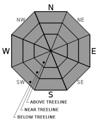
Bottom Line
The avalanche danger is LOW for all elevations and aspects throughout the forecast area. NORMAL CAUTION is advised. Always practice safe travel protocols. Watch for unstable snow on isolated terrain features and falling rime ice off the upper mountain.


Avalanche Problem 1: Normal Caution
-
Character ?

-
Aspect/Elevation ?
-
Likelihood ?CertainVery LikelyLikelyPossible
 Unlikely
 -
Size ?HistoricVery LargeLargeSmall

NORMAL CAUTION means:
- Always watch for isolated slabs.
- Ski and ride one at a time in avalanche terrain
- Don't regroup in run out zones
- Basic avalanche rescue skills are essential anytime you travel in avalanche terrain.
Isolated slabs are generally related to wind and terrain: look for places where small areas of drifting have occurred and firm layers of surface snow overlie softer layers. Often this will occur on the lee side of ridges, in terrain depressions, on convex terrain features, and in the lee of isolated bands of trees.
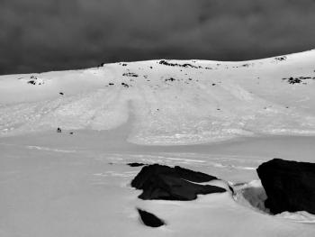
RIME ICE WARNING: If you're venturing onto the upper mountain, take note. Rime ice is actively flaking off exposed rocks and down slopes below. Wear a helmet and proceed with caution or simply, avoid these areas all together. In Avalanche Gulch - above Helen Lake, but below Redbanks - is where this problem is most prevalent.
Forecast Discussion
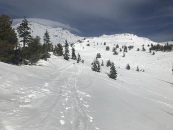
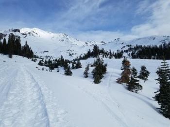
Winter feels like a sinking ship, but we're keeping our heads above water and sails hoisted high. A usable, albeit thin snowpack holds strong below treeline despite the warm temperatures this past week. Treeline hosts 3-4 feet of isothermic snow on the south side of Mount Shasta. Just remember, it can be worse. In 2014, we had 1/4 of the snow we have now at this same time. Falling rime ice on the upper mountain is the main hazard for today. Wear a helmet. Carry an ice axe and crampons along with a beacon, shovel and probe. Know how to use this equipment.
Recent Observations
Yesterday, warm temperatures and windy condtions ruled the advisory area. Today marks a week of above freezing overnight temperatures, reported from both our Old Ski Bowl and Grey Butte weather stations. Surprisingly, we have not observed any loose-wet activity during the day. Most snow below 8,000 feet is soft, moist and mushy. Shallow snowpack hazards are beginning to show again. Bare ground is showing around the big, Shasta Red Fir trees. On the upper mountain, rime ice thwarted a couple climbers on the Avalanche Gulch route. Near constant rime ice pelted the climbers in "the bowling alley" above Helen Lake. Some rockfall was observed also. Firm, icy snow surface conditions were encountered near The Heart. It's a diverse assortment of various sun/wind crusts, sastrugi/wind eroded features, scoured icy snow surfaces and smooth corn snow. Play your aspect, elevation and time of day cards correctly and you could be rewarded with some decent sliding and riding. No signs of instability have been observed since Tuesday.
Weather and Current Conditions
Weather Summary
The repeat button is stuck. While no day is ever the same, today will be darn close to yesterday. Dry conditions persist with above normal temperatures and below normal precipitation. Mostly clear skies and sun is in the box for the near future. Expect windy conditions above treeline on the mountain. Visit the NOAA Climate Prediction Center for temperature and precipitation models.
24 Hour Weather Station Data @ 4:00 AM
| Weather Station | Temp (°F) | Wind (mi/hr) | Snow (in) | Comments | ||||||||
|---|---|---|---|---|---|---|---|---|---|---|---|---|
| Cur | Min | Max | Avg | Avg | Max Gust | Dir | Depth | New | Water Equivalent | Settlement | ||
| Mt. Shasta City (3540 ft) | 51 | 41 | 62 | 52.5 | 5 | |||||||
| Sand Flat (6750 ft) | 36 | 31 | 52 | 39 | 21 | 0 | 0 | 2 | ||||
| Ski Bowl (7600 ft) | 41.5 | 36 | 52 | 43 | 41.5 | 0 | 0 | .5 | ||||
| Gray Butte (8000 ft) | 38.5 | 37 | 51.5 | 43.5 | 4 | 12 | SSE | |||||
| Castle Lake (5870 ft) | 42.5 | 39 | 49 | 43 | 9 | 0 | .5 | |||||
| Mount Eddy (6509 ft) | 41.5 | 38 | 51.5 | 43.5 | 2 | 16 | SSE | 23 | 0 | 0 | ||
| Ash Creek Bowl (7250 ft) | 0 | 0 | 0 | 0 | 0 | 0 | station down | |||||
| Ash Creek Ridge (7895 ft) | 0 | 0 | 0 | 0 | 0 | 0 | station down |
Two Day Mountain Weather Forecast
Produced in partnership with the Medford NWS
| For 7000 ft to 9000 ft | |||
|---|---|---|---|
|
Saturday (4 a.m. to 10 p.m.) |
Saturday Night (10 p.m. to 4 a.m.) |
Sunday (4 a.m. to 10 p.m.) |
|
| Weather | Sunny | Mostly clear | Sunny |
| Temperature (°F) | 52 | 37 | 52 |
| Wind (mi/hr) | North 10-15 mi/hr | North 10-15 mi/hr | North 5-10 mi/hr |
| Precipitation SWE / Snowfall (in) | / 0 | / 0 | / 0 |
| For 9000 ft to 11000 ft | |||
| Saturday | Saturday Night | Sunday | |
| Weather | Sunny and windy | Mostly clear and windy | Sunny and breezy |
| Temperature (°F) | 37 | 35 | 36 |
| Wind (mi/hr) | North 20-30 mi/hr | North 0 | Northwest 10-20 mi/hr |
| Precipitation SWE / Snowfall (in) | / 0 | / 0 | / 0 |
Season Precipitation for Mount Shasta City
| Period | Measured (in) | Normal (in) | Percent of Normal (%) |
|---|---|---|---|
| From Oct 1, 2024 (the wet season) | 10.11 | 22.75 | 44 |
| Month to Date (since Apr 1, 2025) | 0.00 | 0.48 | 0 |
| Year to Date (since Jan 1, 2025) | 4.28 | 7.54 | 57 |

