You are here
Avalanche Advisory for 2018-03-24 06:32
- EXPIRED ON March 25, 2018 @ 6:32 amPublished on March 24, 2018 @ 6:32 am
- Issued by Nick Meyers - Shasta-Trinity National Forest
Bottom Line
Incessant southwesterly winds have combined with 17 inches of new, low density snow over the past 24 hours. CONSIDERABLE avalanche danger exists near and above treeline. Avalanche problems could include senstive wind slabs, cornice features and/or loose dry avalanches as you travel through avalanche terrain in the Mount Shasta backcountry. Lingering showers and windy conditions will persist. Today is a day to be on your toes.
Avalanche Problem 1: Wind Slab
-
Character ?

-
Aspect/Elevation ?

-
Likelihood ?CertainVery LikelyLikelyPossible
 Unlikely
 -
Size ?HistoricVery LargeLargeSmall

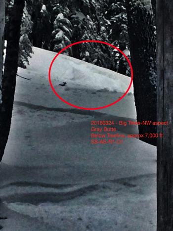
The past 3 days have been a wind tunnel on Mount Shasta. Pair that up with ample new snow (HN24 - 17 inches) and what you get is a lot of wind loading. Gray Butte (8,000 ft) has averaged 18 mi/hr with gusts to 49 mi/hr, almost exclusively out of the SW/W. Gusty, erratic winds can produce unexpected and complex wind loading patterns. Continued strong winds and new snow will aid with wind slab growth. Slabs have been observed up to 2 feet thick. Visible blowing snow, wind drifts, shooting cracks, wind eroded snow surfaces, and hollow sounding snow are all signs that you may be on or near a wind slab problem. Look for wind slabs in leeward terrain near and above treeline. Avoid them by sticking to protected or wind scoured areas. Steer clear of wind loaded slopes 35 degrees and steeper and avoid runout zones.
Avalanche Problem 2: Loose Dry
-
Character ?

-
Aspect/Elevation ?

-
Likelihood ?CertainVery LikelyLikelyPossible
 Unlikely
 -
Size ?HistoricVery LargeLargeSmall

Yesterday, loose dry avalanches were easily started on small, steep test slopes below and near treeline. Loose dry sluffs are usually small, but may gain significant mass on long, steep slopes, typically greater than 40 degrees. They are best managed by avoiding terrain traps and large steep slopes until the surface has stabilized. One can occasionally move across the fall line to avoid being caught by your own sluffs from above.
Avalanche Problem 3: Cornice
-
Character ?

-
Aspect/Elevation ?

-
Likelihood ?CertainVery LikelyLikelyPossible
 Unlikely
 -
Size ?HistoricVery LargeLargeSmall

While not directly observed, we suspect that ridgelines near and above treeline will have fresh cornice formations, small to medium in size, that will be easily triggerable. Cornices may trigger slab avalanches on slopes below. Stay back on terra firma folks!
Forecast Discussion
There is no magic in todays forecast...the writing is on the wall. Yesterday, signs of unstable snow were observed and the hard data supports it. Ski and ride one at a time in avalanche terrain. Don't regroup in run out zones. Play it safe. Don't let this late season, cold smoke-powder action bring you under.
Recent Observations
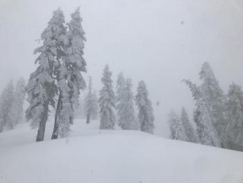
A blizzard was an understatement on Gray Butte yesterday afternoon. Light snow in the morning gradually increased in intensity and by later in the day, it was hammering down. A storm total of 17 inches (.43" water equivalent) has been recorded at treeline over the past 24 hours. This very low density new snow was poorly bonded to old snow surfaces, loose and dry. Old, hard snow surfaces could be felt during ski and boot penetration. Southwesterly winds have been incessant, averaging 18 mph with gusts in the 30 to 40 mph range. Temps have averaged 17 def F at 8,000 feet. Wind effect is noticeable around 7,500 feet and prominent above 8,000 feet. Loose-dry sluffs were easily initiated on steep slopes. Surface cracking of new snow layers was observed near and above treeline. Exposed areas remained scoured. Wind loading was in full effect and wind slabs 1 to 2 feet thick were measured near and above treeline. Visibility was less than 100 yards for most of the late afternoon observations. While we played it safe, the snowpack exhibited several signs of instability, more so than we've seen in the past few windless storms.
Weather and Current Conditions
Weather Summary
Snow will continue through this morning as the low moves toward the coast bringing additional precipitation onshore. The precipitation will drift eastward during the afternoon hours as the low gradually weakens. Temperatures will remain cold. Snow levels will stay near town or lower. Precipitation (water) amounts look to be around .27" over the course of the day, which could mean a couple more inches of snow. Strong winds will continue to blow above treeline out of the southwest, tapering off tomorrow. Sunday, high pressure will start to build. Showery conditions are possible; accumulation will be light. Eventually, drier air and off shore flow should build later next week allowing for more spring-like weather.
24 Hour Weather Station Data @ 3:00 AM
| Weather Station | Temp (°F) | Wind (mi/hr) | Snow (in) | Comments | ||||||||
|---|---|---|---|---|---|---|---|---|---|---|---|---|
| Cur | Min | Max | Avg | Avg | Max Gust | Dir | Depth | New | Water Equivalent | Settlement | ||
| Mt. Shasta City (3540 ft) | 39 | 36 | 43 | 39.5 | 1 | N | ||||||
| Sand Flat (6750 ft) | station down | |||||||||||
| Ski Bowl (7600 ft) | 10.5 | 10.5 | 21.5 | 18 | 93.2 | 17.7 | 0.43 | 1.5 | ||||
| Gray Butte (8000 ft) | 14.5 | 12.5 | 21 | 17.5 | 18 | 43 | SW | |||||
| Castle Lake (5870 ft) | 0 | 0 | 0 | 0 | 0 | 0 | 0 | station down | ||||
| Mount Eddy (6509 ft) | 13.5 | 13.5 | 25 | 21 | 2 | 16 | SW | 55.7 | 12.6 | 2.5 | ||
| Ash Creek Bowl (7250 ft) | station down | |||||||||||
| Ash Creek Ridge (7895 ft) | station down |
Two Day Mountain Weather Forecast
Produced in partnership with the Medford NWS
| For 7000 ft to 9000 ft | |||
|---|---|---|---|
|
Saturday (4 a.m. to 10 p.m.) |
Saturday Night (10 p.m. to 4 a.m.) |
Sunday (4 a.m. to 10 p.m.) |
|
| Weather | Mostly cloudy, chance of snow showers this morning, then snow showers likely this afternoon. | Snow showers in the evening and after midnight. | Mostly cloudy with a 40% chance of snow showers. |
| Temperature (°F) | 26 | 17 | 31 |
| Wind (mi/hr) | S 5-10 mi/hr | S 5-10 mi/hr | W 0-5 mi/hr |
| Precipitation SWE / Snowfall (in) | / 2-5 | / 2-5 | / 0-1 |
| For 9000 ft to 11000 ft | |||
| Saturday | Saturday Night | Sunday | |
| Weather | Snow showers, mainly after 11am. Windy. | Snow showers, breezy. | A 40% chance of snow showers, partly sunny and cold. |
| Temperature (°F) | 8 | 5 | 9 |
| Wind (mi/hr) | SW 25-30 mi/hr | SW 3-6 | NW 10-15 mi/hr |
| Precipitation SWE / Snowfall (in) | / 3-6 | / 3-6 | / 0-1 |
Season Precipitation for Mount Shasta City
| Period | Measured (in) | Normal (in) | Percent of Normal (%) |
|---|---|---|---|
| From Oct 1, 2024 (the wet season) | 15.80 | 34.36 | 46 |
| Month to Date (since Dec 1, 2024) | 4.91 | 4.86 | 101 |
| Year to Date (since Jan 1, 2024) | 9.97 | 19.15 | 52 |


