You are here
Avalanche Advisory for 2018-04-08 07:01
- EXPIRED ON April 9, 2018 @ 7:01 amPublished on April 8, 2018 @ 7:01 am
- Issued by Andrew Kiefer - Mt Shasta Avalanche Center
Bottom Line
The avalanche danger is LOW for all elevations. Watch for isolated wind slabs in steep leeward terrain at upper elevations on Mount Shasta. Rain on snow up to 10,000 ft Friday was followed by cold temperatures and strong southerly winds yesterday. A supportable rain crust now caps snow surfaces near and above treeline creating very slick and icy conditions.
Avalanche Problem 1: Normal Caution
-
Character ?

-
Aspect/Elevation ?

-
Likelihood ?CertainVery LikelyLikelyPossible
 Unlikely
 -
Size ?HistoricVery LargeLargeSmall

Both natural and human triggered avalanches are unlikely, and NORMAL CAUTION is advised. LOW avalanche danger does not mean NO avalanche danger:
- In alpine areas on Mount Shasta, watch for isolated wind slabs where areas of drifting have occurred. Of most concern are east facing slopes steeper than 35 degrees above 10,000 ft.
- Small cornice formations exist along ridgelines. Avoid traveling on or underneath these features.
- The wet loose avalanche cycle may have already run its course. Continue to use caution during periods of intense solar radiation this afternoon and tomorrow by avoiding steep slopes near and below treeline with wet unconsolidated snow surfaces.
Forecast Discussion
The rain on snow event closing out our recent storm resulted in numerous wet loose avalanches near and below treeline overnight on Friday. Strong southerly winds yesterday refroze snow surfaces, and a supportable and dangerously slick rain crust formed 8,000 ft and higher. Observations above treeline have been very limited during the storm due to poor visibility. Several inches of snow have recently accumulated at upper elevations, and wind loading has likely occurred. Firm and icy snow surfaces exist above 8,000 ft, and even low angle slopes presented challenging travel conditions yesterday.
Recent Observations
Since Thursday, the Old Ski Bowl weather station received 3.28 inches of water, translating to 10 inches of wet heavy snow and rain. The new snow has already settled 6 inches, and 4-5 inches of wet heavy snow remain at the snow surface between 7,000-8,000 ft. Over the past 24 hours, winds at Gray Butte have been strong out of the W/SW with gusts to 49 mph.
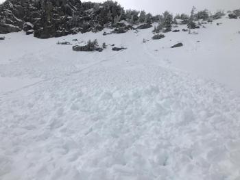
On Friday night, the storm finished with rain falling on snow up to 9,000-10,000 ft which caused a natural wet loose avalanche cycle. Despite low visibility yesterday, numerous wet loose avalanches up to destructive size 1.5 were observed on E-SE-S-SW-W-NW aspects between 7,500-9,000 ft on Gray Butte, Green Butte, Yellow Butte and in Sun Bowl. See the RECENT OBSERVATION for more information.
Strong southerly winds yesterday followed the rain on snow event. Snow surfaces at 8,000 ft and higher are now locked up by a stout rain crust. How high up the rain crust extends is unknown, as travel above 8,000 ft (where the rain crust becomes supportable) was extremely slick and challenging. Upper elevation observations have been limited during the storm due to whiteout conditions and poor visibility.
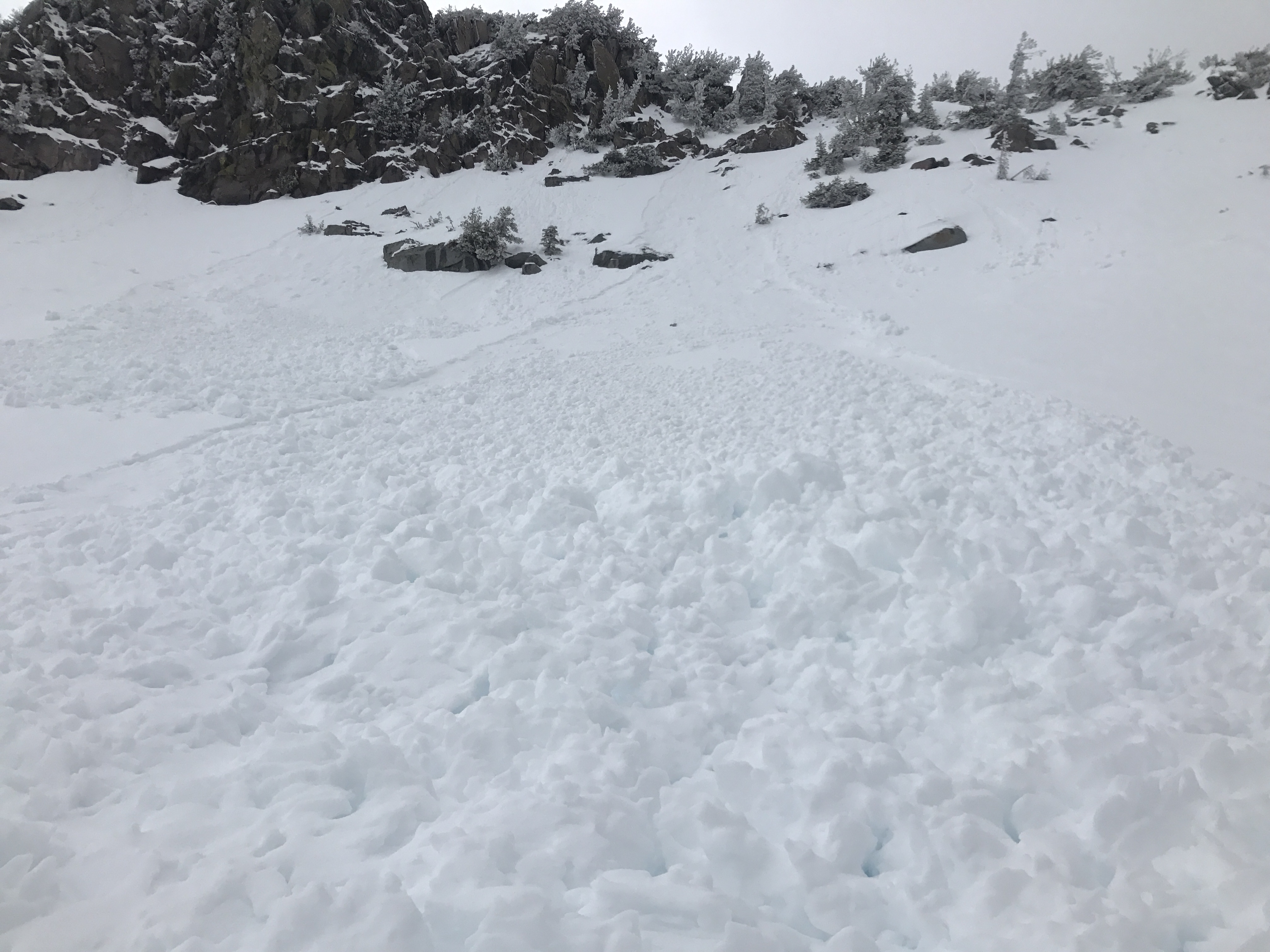
(WL-N-R1-D1) Observed 04/07/18 on a SW aspect of Yellow Butte at 8100 ft
Weather and Current Conditions
Weather Summary
A slight chance for lingering showers continues this morning before high pressure builds in the area tonight and tomorrow. Today will start off cloudy with gradual clearing throughout the day. Highs will be in the mid 40s. Above treeline, strong and gusty S/SW winds will continue to blow 30-40 mph. Tonight will be clear and windy. Tomorrow will be sunny with highs near 60 degrees at 6,000 ft, likely the warmest temperatures we have seen so far this year. A series of disturbances will bring a return to wet and windy weather Tuesday through Thursday.
24 Hour Weather Station Data @ 6:00 AM
| Weather Station | Temp (°F) | Wind (mi/hr) | Snow (in) | Comments | ||||||||
|---|---|---|---|---|---|---|---|---|---|---|---|---|
| Cur | Min | Max | Avg | Avg | Max Gust | Dir | Depth | New | Water Equivalent | Settlement | ||
| Mt. Shasta City (3540 ft) | 39 | 39 | 55 | 47.5 | 3 | |||||||
| Sand Flat (6750 ft) | station down | |||||||||||
| Ski Bowl (7600 ft) | 23.5 | 23 | 36.5 | 28.5 | 76 | 1 | 0.11 | 2 | ||||
| Gray Butte (8000 ft) | 22.5 | 22.5 | 35.5 | 27.5 | 19 | 49 | WSW | |||||
| Castle Lake (5870 ft) | station down | |||||||||||
| Mount Eddy (6509 ft) | 26 | 26 | 38.5 | 32.5 | 2 | 13 | SSE | 39 | .5 | 1 | ||
| Ash Creek Bowl (7250 ft) | station down | |||||||||||
| Ash Creek Ridge (7895 ft) | station down |
Two Day Mountain Weather Forecast
Produced in partnership with the Medford NWS
| For 7000 ft to 9000 ft | |||
|---|---|---|---|
|
Sunday (4 a.m. to 10 p.m.) |
Sunday Night (10 p.m. to 4 a.m.) |
Monday (4 a.m. to 10 p.m.) |
|
| Weather | 30% chance of snow showers before 11am then mostly sunny in the afternoon | Mostly clear | Sunny |
| Temperature (°F) | 42 | 33 | 57 |
| Wind (mi/hr) | S/SW 10-15 | W 10-15 | E 0-5 |
| Precipitation SWE / Snowfall (in) | / 0 | / 0 | / 0 |
| For 9000 ft to 11000 ft | |||
| Sunday | Sunday Night | Monday | |
| Weather | 30% chance of snow showers before 11am then mostly sunny. Windy. | Mostly clear and windy | Sunny and breezy |
| Temperature (°F) | 26 | 26 | 35 |
| Wind (mi/hr) | W 35-45 | NW 0 | SW 10-20 |
| Precipitation SWE / Snowfall (in) | / 0 | / 0 | / 0 |
Season Precipitation for Mount Shasta City
| Period | Measured (in) | Normal (in) | Percent of Normal (%) |
|---|---|---|---|
| From Oct 1, 2024 (the wet season) | 17.17 | 36.27 | 47 |
| Month to Date (since Dec 1, 2024) | 1.22 | 0.81 | 151 |
| Year to Date (since Jan 1, 2024) | 11.34 | 21.06 | 54 |


