You are here
Avalanche Forecast for 2021-01-20 06:00
- EXPIRED ON January 21, 2021 @ 6:00 amPublished on January 20, 2021 @ 6:00 am
- Issued by Aaron Beverly - Mount Shasta Avalanche Center
Bottom Line
Avalanche danger is low. Use normal caution as you travel. Though sunny skies, warmer temperatures, and light winds may allow snow surfaces to soften, be prepared for firm, icy conditions and breakable crusts. Bring an ice axe, crampons, and helmet if ascending steep terrain. Expect slide-for-life conditions.
Avalanche Problem 1: Normal Caution
-
Character ?

-
Aspect/Elevation ?

-
Likelihood ?CertainVery LikelyLikelyPossible
 Unlikely
 -
Size ?HistoricVery LargeLargeSmall

Avalanche danger is low. Use normal caution as you travel. Firm, icy conditions and breakable crusts are the main hazards for which to be prepared. Bring an ice axe, crampons, and helmet if ascending steep terrain. Expect slide-for-life conditions.
Forecast Discussion
Recent Observations
Northeast winds have been strong to gale force in the last 24 hours above treeline. Gusts at Bunny Flat could knock you off your feet. I thought there was no more snow to transport, but some was indeed blowing over the Trinity Chutes and the West Face -- probably mostly sublimating.
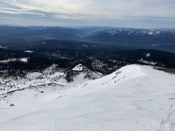
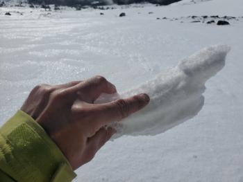
Snow surfaces are hardened by wind and melt-freeze cycles.Be prepared for teeth chattering skiing and slide-for-life conditions.
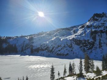
This is what Mount Shasta looks like at the moment:

Weather and Current Conditions
Weather Summary
If you are looking for spring skiing conditions in January, today and tomorrow may be the days to venture out. Sunny skies, warm temperatures, and light winds may allow the boilerplate snowpack to warm up enough to give you a thin, soft surface to slide on. Temperatures will peak around 1 p.m.
We'll get a skiff of snow late Thursday night. That cursed, never-ending, high pressure blob that lurks out in the Pacific may actually break down for a bit next week allowing cold temps and moisture to swing in from the far north. Don't jinx it with snow dancing.
24 Hour Weather Station Data @ 5:00 AM
| Weather Station | Temp (°F) | Wind (mi/hr) | Snow (in) | Comments | ||||||||
|---|---|---|---|---|---|---|---|---|---|---|---|---|
| Cur | Min | Max | Avg | Avg | Max Gust | Dir | Depth | New | Water Equivalent | Settlement | ||
| Mt. Shasta City (3540 ft) | 24 | 24 | 47 | 33 | 2 | N | ||||||
| Sand Flat (6750 ft) | 23 | 18 | 34 | 26 | 0 | 0 | snow depth sensor broken | |||||
| Ski Bowl (7600 ft) | 37 | 25 | 38.5 | 32.5 | 38.4 | 0 | 0 | 0.8 | ||||
| Gray Butte (8000 ft) | 40.5 | 22.5 | 41.5 | 31 | 28 | 67 | E | |||||
| Castle Lake (5870 ft) | 31.5 | 23 | 37 | 31 | 6 | 0 | 0 | |||||
| Mount Eddy (6509 ft) | 32 | 20.5 | 35 | 29.5 | 2 | 6 | SW | 11.6 | 0 | 22.5 | ||
| Ash Creek Bowl (7250 ft) | 35.5 | 17.5 | 35.5 | 28 | 32.4 | 0 | 0.2 | |||||
| Ash Creek Ridge (7895 ft) | 38 | 12.5 | 38 | 25.5 | 3 | 16 | SW |
Two Day Mountain Weather Forecast
Produced in partnership with the Medford NWS
| For 7000 ft to 9000 ft | |||
|---|---|---|---|
|
Wednesday (4 a.m. to 10 p.m.) |
Wednesday Night (10 p.m. to 4 a.m.) |
Thursday (4 a.m. to 10 p.m.) |
|
| Weather | Sunny. | Partly cloudy. | Mostly sunny. |
| Temperature (°F) | 43 | 28 | 37 |
| Wind (mi/hr) | Northeast 0-5 | West 0-5 | Southwest 0-5 |
| Precipitation SWE / Snowfall (in) | 0.00 / 0 | 0.00 / 0 | 0.00 / 0 |
| For 9000 ft to 11000 ft | |||
| Wednesday | Wednesday Night | Thursday | |
| Weather | Sunny. | Partly cloudy. | Mostly sunny. Breezy. Low wind chills. |
| Temperature (°F) | 37 | 23 | 23 |
| Wind (mi/hr) | North 15-20 | West 10-15 | West 20-25 |
| Precipitation SWE / Snowfall (in) | 0.00 / 0 | 0.00 / 0 | 0.00 / 0 |
Season Precipitation for Mount Shasta City
| Period | Measured (in) | Normal (in) | Percent of Normal (%) |
|---|---|---|---|
| From Oct 1, 2024 (the wet season) | 5.75 | 19.69 | 29 |
| Month to Date (since Apr 1, 2025) | 2.17 | 4.48 | 48 |
| Year to Date (since Jan 1, 2025) | 2.17 | 4.48 | 48 |


