You are here
Avalanche Forecast for 2021-02-04 06:00
- EXPIRED ON February 5, 2021 @ 6:00 amPublished on February 4, 2021 @ 6:00 am
- Issued by Aaron Beverly - Mount Shasta Avalanche Center
Bottom Line
Avalanche danger is moderate. Triggering old and new wind slab avalanches is possible. The spate of wintry storms is over. Clear, sunny weather lies ahead.
Avalanche Problem 1: Wind Slab
-
Character ?

-
Aspect/Elevation ?

-
Likelihood ?CertainVery LikelyLikelyPossible
 Unlikely
 -
Size ?HistoricVery LargeLargeSmall

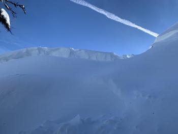
As you travel near and above treeline, be cautious around leeward terrain. Cornice breaks and small wind slab avalanches have occurred on north and southeast facing aspects. These instabilities may continue to linger.
New snow from yesterday's storm coupled with productive winds have probably created new slabs. Outlier regions, such as Park's Creek, where more snow fell from yesterday's storm will be of the most concern. Evaluate snow and terrain carefully today. Human triggered avalanches remain possible.
Forecast Discussion
Everitt Memorial Highway and Castle Lake Road are closed. Everitt is expected to open sometime tomorrow.
Recent Observations
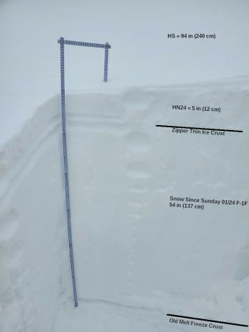
Yesterday morning's storm brought about 3 inches of new snow to the Old Ski Bowl. Moderate west winds blew throughout its duration maxing out at 23 mi/hr.
The Eddies seemed to enjoy better snow totals with the Mount Eddy weather station reporting 6 inches of new snow. Observed totals near Deadfall Lakes were 8-10 inches. This new snow was accompanied by moderate and productive northwest winds.
Small D1 wind slab avalanches have occurred on north and southeast facing aspects in the Eddy range.
Weather and Current Conditions
Weather Summary
It's been a nice stretch of cold, wintry storms, but its time to settle back into several days of melt-freeze cycles. Higher temperatures and sunny weather will begin to soften up south and east facing slopes during the day. North winds will be moderate to strong.
Snow from the last 10 days has helped our overall precipitation stats for the season. We are 55% of normal for the season and 116% of normal for the year.
24 Hour Weather Station Data @ 5:00 AM
| Weather Station | Temp (°F) | Wind (mi/hr) | Snow (in) | Comments | ||||||||
|---|---|---|---|---|---|---|---|---|---|---|---|---|
| Cur | Min | Max | Avg | Avg | Max Gust | Dir | Depth | New | Water Equivalent | Settlement | ||
| Mt. Shasta City (3540 ft) | 27 | 27 | 39 | 31.5 | 2 | N | ||||||
| Sand Flat (6750 ft) | 13 | 13 | 25 | 20 | ||||||||
| Ski Bowl (7600 ft) | 19.5 | 13.5 | 26 | 18.5 | 80 | 2.7 | 0.13 | 0 | ||||
| Gray Butte (8000 ft) | 18 | 14 | 26 | 17.5 | 10 | 43 | WNW | |||||
| Castle Lake (5870 ft) | 20 | 18.5 | 30 | 22.5 | 67.7 | 4.3 | 0 | |||||
| Mount Eddy (6509 ft) | 22.5 | 18 | 24 | 21 | 2 | 7 | SSW | 71.4 | 4.6 | 0 | ||
| Ash Creek Bowl (7250 ft) | not responding | |||||||||||
| Ash Creek Ridge (7895 ft) | not responding |
Two Day Mountain Weather Forecast
Produced in partnership with the Medford NWS
| For 7000 ft to 9000 ft | |||
|---|---|---|---|
|
Thursday (4 a.m. to 10 p.m.) |
Thursday Night (10 p.m. to 4 a.m.) |
Friday (4 a.m. to 10 p.m.) |
|
| Weather | Sunny. | Clear. | Sunny. Breezy. |
| Temperature (°F) | 34 | 31 | 36 |
| Wind (mi/hr) | North 10-15 | Northwest 15-20 | Northwest 20-25 |
| Precipitation SWE / Snowfall (in) | 0.00 / 0 | 0.00 / 0 | 0.00 / 0 |
| For 9000 ft to 11000 ft | |||
| Thursday | Thursday Night | Friday | |
| Weather | Sunny. Windy. Low wind chills. | Clear. Windy. Low wind chills. | Sunny. Windy. Low wind chills. |
| Temperature (°F) | 30 | 22 | 31 |
| Wind (mi/hr) | North 30-35 | North 35-45 | North 40-50 |
| Precipitation SWE / Snowfall (in) | 0.00 / 0 | 0.00 / 0 | 0.00 / 0 |
Season Precipitation for Mount Shasta City
| Period | Measured (in) | Normal (in) | Percent of Normal (%) |
|---|---|---|---|
| From Oct 1, 2024 (the wet season) | 12.60 | 23.00 | 55 |
| Month to Date (since Apr 1, 2025) | 1.16 | 0.73 | 159 |
| Year to Date (since Jan 1, 2025) | 9.02 | 7.79 | 116 |


