You are here
Avalanche Forecast for 2021-03-03 06:00
- EXPIRED ON March 4, 2021 @ 6:00 amPublished on March 3, 2021 @ 6:00 am
- Issued by Aaron Beverly - Mount Shasta Avalanche Center
Bottom Line
Avalanche danger is low. Challenging conditions exist for climbers and skiers. Be prepared for firm, icy conditions above treeline. Look out for falling rock. Today will be the last of the warm, sunny days. Low pressure from Alaska will begin to impact the area tomorrow. Snow is coming this weekend and will continue throughout next week.
Avalanche Problem 1: Normal Caution
-
Character ?

-
Likelihood ?CertainVery LikelyLikelyPossible
 Unlikely
 -
Size ?HistoricVery LargeLargeSmall

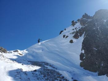
Avalanche danger is low. Challenging conditions exist for climbers and skiers. Be prepared for firm, icy conditions above treeline. Look out for falling rock. Climbing the mountain is not recommended, but if you attempt it, bring an ice axe, crampons, and helmet.
Overhanging cornices exposed to direct sun and warm temperatures may have begun to loosen. Be cautious if traveling above or below them.
Recent Observations
There is 67 inches of snow at 7,600 ft on Mount Shasta. In the last 24 hours, near treeline temperatures have averaged 32 ºF and peaked at 44. Measured winds have been light to moderate and southerly.
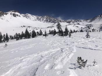
There is plenty of dirt and exposed and fallen rock above treeline. Climbing routes do not hold much snow. Skiers will find inconsistent snow surface conditions - soft to firm, sastrugis, crusts, and wind affected chalk.
Castle Lake still has a decent usable snowpack, though manzanita is beginning to poke through on Right Peak. Snow depth is 61 inches. Temperatures peaked there yesterday at 52.5 ºF. The lake is frozen and supportable.

Castle Lake
Weather and Current Conditions
Weather Summary
Today will be the last day to search for spring skiing conditions. You'll find them mostly near and below treeline or at lower elevations. A series of low pressure systems moving down from Alaska will begin impacting the area early tomorrow. The first system will bring strong to gale force southerly winds and cooler temperatures.
The next one will begin affecting the region Saturday. Snow levels may start high but will drop. We'll see snow at low elevations by Monday. Over the weekend 0.79 inches of precipitable water is expected. This could translate into up to 8 inches of snow. It is a bit early to get excited, but snow is in the forecast everyday next week.
24 Hour Weather Station Data @ 5:00 AM
| Weather Station | Temp (°F) | Wind (mi/hr) | Snow (in) | Comments | ||||||||
|---|---|---|---|---|---|---|---|---|---|---|---|---|
| Cur | Min | Max | Avg | Avg | Max Gust | Dir | Depth | New | Water Equivalent | Settlement | ||
| Mt. Shasta City (3540 ft) | 25 | 25 | 61 | 40 | 0 | N | ||||||
| Sand Flat (6750 ft) | 26 | 25 | 43 | 33 | 0 | Snow sensor down | ||||||
| Ski Bowl (7600 ft) | 31.5 | 27.5 | 44 | 34.5 | 33.8 | 0 | 0 | 0 | ||||
| Gray Butte (8000 ft) | 32.5 | 27 | 38.5 | 33 | 5 | 25 | SSW | |||||
| Castle Lake (5870 ft) | 37.5 | 32 | 52.5 | 39.5 | 61.3 | 0.5 | 0 | |||||
| Mount Eddy (6509 ft) | 26 | 25.5 | 43 | 33.5 | 2 | 6 | WSW | 57.3 | 0 | 0.5 | ||
| Ash Creek Bowl (7250 ft) | 34.5 | 29.5 | 40.5 | 35 | 56 | 0 | 0.4 | |||||
| Ash Creek Ridge (7895 ft) | 30 | 25.5 | 39 | 31.5 | 8 | 22 | S |
Two Day Mountain Weather Forecast
Produced in partnership with the Medford NWS
| For 7000 ft to 9000 ft | |||
|---|---|---|---|
|
Wednesday (4 a.m. to 10 p.m.) |
Wednesday Night (10 p.m. to 4 a.m.) |
Thursday (4 a.m. to 10 p.m.) |
|
| Weather | Sunny. | Increasing clouds. | Mostly sunny. Breezy. |
| Temperature (°F) | 45 | 26 | 37 |
| Wind (mi/hr) | Southeast 5-10 | South 5-10 | South 15-20 |
| Precipitation SWE / Snowfall (in) | 0.00 / 0 | 0.00 / 0 | 0.00 / 0 |
| For 9000 ft to 11000 ft | |||
| Wednesday | Wednesday Night | Thursday | |
| Weather | Sunny. Breezy. | Increasing clouds. Windy. Low wind chills. | Mostly sunny. Very windy. Low wind chills. |
| Temperature (°F) | 27 | 23 | 26 |
| Wind (mi/hr) | South 15-20 | Southwest 20-25 | Southwest 50-60 |
| Precipitation SWE / Snowfall (in) | 0.00 / 0 | 0.00 / 0 | 0.00 / 0 |
Season Precipitation for Mount Shasta City
| Period | Measured (in) | Normal (in) | Percent of Normal (%) |
|---|---|---|---|
| From Oct 1, 2024 (the wet season) | 13.58 | 30.03 | 45 |
| Month to Date (since Apr 1, 2025) | 0.00 | 0.53 | 0 |
| Year to Date (since Jan 1, 2025) | 10.00 | 14.82 | 67 |


