You are here
Grey Butte

Location Name:
Grey ButteRegion:
Mt. ShastaDate and time of avalanche (best estimate if unknown):
Mon, 01/23/2017 - 10:00amObservation made by:
ForecasterRed Flags:
Recent avalanche activity
Whumphing noises, shooting cracks, or collapsing
Recent loading by new snow, wind, or rain
Obvious avalanche path
Location Map
United States
41° 20' 56.094" N, 122° 11' 39.084" W
See map: Google Maps
US
Avalanche Observations
Details
Snow Pit / Crown Profile Photos
Characteristics
Avalanche Type:
DrySlabTrigger type:
NaturalSlope:
35degreesAspect:
NorthwestElevation:
8 000ft.Terrain:
Near TreelineWeak Layer:
Storm SnowBed Surface:
Storm SnowCrown Height:
3 ftAvalanche Width:
900ft.Avalanche Length:
600ft.Weather Observations
Details
Sky was obscured for most of the day above 5000ft. Winds were light throughout the day. Snowfall was minimal, and no new snow accumulation was observed.
Statistics
Cloud Cover:
100% of the sky covered by cloudsBlowing Snow:
YesPrecipitation:
SnowAccumulation rate:
Less than 1 in. per hourAir temperature:
Below FreezingAir temperature trend:
CoolingWind Speed:
LightWind Direction:
West


SS-NS-R2-D2-S
Natural wind slab avalanche occurred during our recent storm events, likely 2 days ago. The avalanche occurred near treeline on a northwest aspect at 8000ft on Grey Butte. The crown of the avalanche ranged from 3-4ft, and the bed surface had filled in with at least 2 additional feet of new snow since the event. The crown was about 900ft wide and the avalanche ran 600ft to the bottom of the slope.
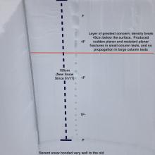
The snowpit photo below is of a test pit dug today in an area nearby the avalanche on a south facing slope at 7840ft.