You are here
Sun Bowl Avalanche

Location Name:
Sun BowlRegion:
Mt. ShastaDate and time of avalanche (best estimate if unknown):
Tue, 02/28/2017 - 4:00pmObservation made by:
Professional ObserverRed Flags:
Recent avalanche activity
Recent loading by new snow, wind, or rain
Location Map
United States
41° 22' 11.5428" N, 122° 12' 55.5768" W
See map: Google Maps
US
Avalanche Observations
Details
Snow Pit / Crown Profile Photos
Characteristics
Avalanche Type:
DrySlabTrigger type:
NaturalSlope:
38degreesAspect:
SoutheastElevation:
8 680ft.Terrain:
Above TreelineWeak Layer:
Old SnowBed Surface:
Old SnowCrown Height:
2 ftAvalanche Width:
900ft.Avalanche Length:
800ft.Number of similar avalanches:
3Weather Observations
Details
A breakable melt freeze crust has formed below 8500' and was encountered on most aspects down to the Bunny Flat parking lot. Some north facing aspects may not have seen this effect yet.
Statistics
Cloud Cover:
25% of the sky covered by cloudsBlowing Snow:
NoPrecipitation:
NoneAccumulation rate:
NoneAir temperature:
Below FreezingAir temperature trend:
WarmingWind Speed:
Calm


Most of sun bowl slid. It appears that there may have been up to 4 different slides. Not clear if they all occurred at the same time. The three smaller ones were likely new windslabs sliding at the new/old snow interface. The more destructive slide occurred within the old snow where an old windslab slid on a rain crust. Some more details:
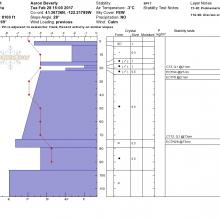
In a test pit dug nearby, failures were triggered below the new wind slab and below an old deep slab on a rain crust.
Though the CT tests yielded unstable results for the new wind slab and old wind slab at 22 cm and 73 cm, the ECT tests were difficult to trigger/propagate at the 73 cm depth.