You are here
Full Profile: Backside Coyote 1-17-17

Location Name:
Coyote BacksideRegion:
Mt. ShastaDate and time of observation:
Tue, 01/17/2017 - 6:05pmObservation made by:
PublicRed Flags:
Obvious avalanche path
Terrain Trap
Location Map
United States
41° 20' 4.3044" N, 122° 11' 39.1992" W
See map: Google Maps
US
Weather Observations
Statistics
Cloud Cover:
75% of the sky covered by cloudsPrecipitation:
NoneAir temperature:
Above FreezingAir temperature trend:
CoolingWind Speed:
LightWind Direction:
South


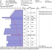
Objective: Full Profile, check for strength of "12-23" weak layer, Stability testing. ECT was conducted - ECTX result but "12-23" failed Q1 with moderate shovel shear pressure after test. Overall rounding is dominant metamorphic process in snowpack. "12-23" layer is observable but has rounded and strengthened since previous obs. While snowpack is still relatively complex with lots of "upside down" sequences, recent warmer temps have moved us closer to a more classic maritime-like stratigraphy.
The snowpack will likely adjust well to the load presented by the forecasted storm, at least at this elevation. Near surface instabilities (storm and wind slabs) will be a concern during and post-storm but deeper instabilities will likely be very stubborn to trigger, especially with skier pressure.