You are here
Everett Memorial Hwy to Old Ski Bowl from McBride Springs

Location Name:
McBride to Old Ski Bowl via EMHRegion:
Mt. ShastaDate and time of observation:
Wed, 01/25/2017 - 9:30pmObservation made by:
ForecasterRed Flags:
Location Map
United States
41° 21' 26.0964" N, 122° 13' 22.3284" W
See map: Google Maps
US
Weather Observations
Details
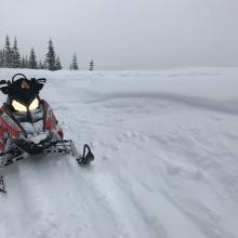
The beginning of the day started of nice with mostly clear skies but mid-day snow flurries moved in and brought up to .5 inches of new, light snow to the mountains. Visibility did not clear during my time on the mountain. Snow accumulation was very light and winds were almost dead calm. Evidence of wind loading was little though likely up higher on the mountain. Temps were cold, in the mid 20's for the day. Snow levels were down to town.
Statistics
Cloud Cover:
100% of the sky covered by cloudsBlowing Snow:
NoPrecipitation:
SnowAccumulation rate:
Less than 1 in. per hourAir temperature:
Below FreezingAir temperature trend:
StaticWind Speed:
CalmWind Direction:
Northwest


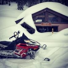
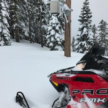
1 cm sun crust from 1.24.17 on southerly aspects below 6,000 feet. Spacial distribution sporadic pending slope angle, slope shading and aspect to the sun. Soft snow surfaces prevail. Everitt Memorial Highway deeply buried. Plowing expected to start on Monday, Jan 30th via rotary. Could be a week or more before it opens. No signs of instability below, near or above treeline. I was only able to get to about 9,000 feet with poor visibility. Repaired the Old Ski Bowl weather station! 13.5 feet measure at site. Snow depth sensor is 20 feet off the ground, could get buried this year. Very little traffic up there. A reminder to snowmobilers, stay BELOW the road from Red Fir Flat all the way to the Old Ski Bowl. Snowmobiling above the road in this section is off limits please.