You are here
Grey Butte Test Pit

Location Name:
Grey ButteRegion:
Mt. ShastaDate and time of observation:
Sat, 12/24/2016 - 9:00pmObservation made by:
ForecasterRed Flags:
Whumphing noises, shooting cracks, or collapsing
Recent loading by new snow, wind, or rain
Location Map
United States
41° 20' 45.3084" N, 122° 11' 43.4868" W
See map: Google Maps
US
Weather Observations
Details
Variable wind direction. The advisory area has experienced primarily Southwest and Northwest winds the past 2 days. However, Easterly winds have also played a significant roll in transporting snow and loading Westerly slopes.
Statistics
Cloud Cover:
50% of the sky covered by cloudsBlowing Snow:
YesPrecipitation:
SnowAccumulation rate:
Less than 1 in. per hourAir temperature:
Below FreezingAir temperature trend:
StaticWind Speed:
LightWind Direction:
Southeast


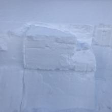
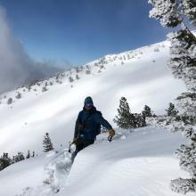
Height of Storm Total was 30cm. Calm winds observed Near and Below Treeline during a tour from the Shasta Ski Park to the Grey Butte Weather Station. Significant blowing of snow occurred above treeline and in upper elevation terrain. Large pillows of snow and wind slabs were growing throughout the day (see photo). Winds kept snow moving above 9000ft and covered tracks between laps. Minor shooting cracks observed on several test slopes. No avalanches or whoomphs observed. Stability testing targeted the old snow/new snow interface, specifically the storm slab problem. A test pit was dug on ENE slope at 7800ft. The old snow/new snow interface was the layer of concern and was buried 40cm down from the surface (minor, uniform wind loading in the area). In all stability tests, failure occurred on the new/old interface on a layer of rounding facets sitting just below a crust. All extended column tests resulted in full propagation on this layer (see photo). Compression tests failed with sudden collapse fractures.
ECTP 12 down 40cm x2
ECTP13 down 40cm
ECTP 16 down 40cm
CT 12 down 40cm SC