You are here
Avalanche Advisory for 2017-12-13 06:20:43
- EXPIRED ON December 14, 2017 @ 6:20 amPublished on December 13, 2017 @ 6:20 am
- Issued by Aaron Beverly - Mount Shasta Avalanche Center
Bottom Line
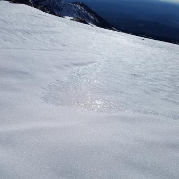
LOW avalanche danger exists in all elevation bands. Natural and human triggered avalanches are unlikely. Exercise normal caution when traveling in the advisory area. Smooth and firm snow surfaces exist and a slide for life could occur in the event of a fall. Bring the proper equipment and know how to use it. Keep an eye out for falling rime ice.
Avalanche Problem 1: Normal Caution
-
Character ?

-
Aspect/Elevation ?

-
Likelihood ?CertainVery LikelyLikelyPossible
 Unlikely
 -
Size ?HistoricVery LargeLargeSmall

Avalanche danger is LOW at all elevations. Natural and human triggered avalanches are unlikely. Normal caution is advised. Normal caution means:
- Be vigilant.
- Travel with a partner.
- Carry a beacon, shovel, and probe.
- Pay attention to changing snow conditions.
- Keep an eye out for isolated pockets of instability in elevation bands above treeline.
Forecast Discussion
If today's advisory sounds like a repeat of yesterday's, it is. The weather cycle is beating to a regular rhythm. If you are reading this daily, know that repetition leads to mastery.
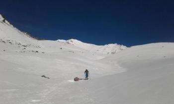
The snowpack is transforming into a cohesive well-consolidated layer. The primary concern is the smooth snow surfaces that will make a slip and fall a life threatening endeavor especially with exposed rocks below. Travel with an ice axe and crampons and the knowledge of how to use them if ascending into the alpine regions of the mountain. These smooth surfaces will make ideal bed surfaces for avalanches when new snow arrives.
A secondary concern is the rime ice spackled on the exposed crags above 11000 feet. Warmer weather may cause this ice to dislodge and plummet down upon climbers. Bring a helmet and be prepared for quick maneuvering if making a summit attempt!
Recent Observations
A temperature inversion remains in the forecast area creating up to a 20 degree difference between 3000' and 8000'. Images from Monday in the Old Ski Bowl show a distinct line locking in smoke and haze at lower elevations. Lows on Mount Shasta in the alpine have remained above 40 degrees F. Despite warmer temperatures above treeline, the snowpack continues to hold its depth with little to no settlement. Hoar frost has been seen on north facing aspects with little exsposure to the wind and sun.
Weather and Current Conditions
Weather Summary
Heartbreak Ridge. The high pressure ridge continues to dominate the weather pattern over the west coast. Though this will weaken slightly on Friday, expect it back in force shortly thereafter, keeping most of the western states out to Colorado and beyond high and dry. Don't expect any precipitation for at least a week. Hearts do mend, and long term forecasts still predict a normal winter, so enjoy the spring skiing while it lasts. With sunny days and cool nights ahead accompanied by light winds, you may find some dreamy corn-like conditions in the afternoon. If you are seeking new rain or snow, head south or north of the border into Mexico or Canada.
-------------------------
THIS SEASON PRECIPITATION for MT SHASTA CITY: Since October 1st (the wet season), we have received 5.72 inches of water, normal is 10.18 inches, putting us at 56% of normal. For the month of December, we have received .18 inches of water, normal is 2.82 inches, which is 6.3% of normal. And finally for the year of 2017, we received 44.71 inches of water, normal is 38.18 inches, putting us at 117% of normal.
Always check the weather before you attempt to climb Mt Shasta. Further, monitor the weather as you climb. Becoming caught on the mountain in any type of weather can compromise life and limb. Be prepared.
24 Hour Weather Station Data @ 5:00 AM
| Weather Station | Temp (°F) | Wind (mi/hr) | Snow (in) | Comments | ||||||||
|---|---|---|---|---|---|---|---|---|---|---|---|---|
| Cur | Min | Max | Avg | Avg | Max Gust | Dir | Depth | New | Water Equivalent | Settlement | ||
| Mt. Shasta City (3540 ft) | 35 | 24 | 45 | 34 | 4 | |||||||
| Sand Flat (6750 ft) | 34 | 30 | 47 | 36 | 14 | 0 | 0 | 1 | ||||
| Ski Bowl (7600 ft) | 52 | 43 | 52 | 49 | 18 | 0 | 0 | 1 | ||||
| Gray Butte (8000 ft) | 51 | 46 | 54 | 51 | 3 | 12 | ENE | |||||
| Castle Lake (5870 ft) | 49 | 45 | 52 | 48 | 0 | 0 | 0 | |||||
| Mount Eddy (6509 ft) | 46 | 35 | 53 | 45 | 3 | 10 | WSW | 0 | 0 | 1 | ||
| Ash Creek Bowl (7250 ft) | ||||||||||||
| Ash Creek Ridge (7895 ft) |
Two Day Mountain Weather Forecast
Produced in partnership with the Medford NWS
| For 7000 ft to 9000 ft | |||
|---|---|---|---|
|
Wednesday (4 a.m. to 10 p.m.) |
Wednesday Night (10 p.m. to 4 a.m.) |
Thursday (4 a.m. to 10 p.m.) |
|
| Weather | Sunny | Clear | Sunny |
| Temperature (°F) | 54 | 39 | 55 |
| Wind (mi/hr) | Northeast 5-7 | Northeast 7-9 | East Northeast 8 |
| Precipitation SWE / Snowfall (in) | / 0 | / 0 | / 0 |
| For 9000 ft to 11000 ft | |||
| Wednesday | Wednesday Night | Thursday | |
| Weather | Sunny | Clear | Sunny |
| Temperature (°F) | 40 | 40 | 42 |
| Wind (mi/hr) | North 8-11 mph | North 0 | Northwest 14-16 mph |
| Precipitation SWE / Snowfall (in) | / 0 | / 0 | / 0 |


