You are here
Avalanche Forecast for 2020-02-08 06:04
- EXPIRED ON February 9, 2020 @ 6:04 amPublished on February 8, 2020 @ 6:04 am
- Issued by Nick Meyers - Shasta-Trinity National Forest
Bottom Line
Hold on to your hat today folks, northwest wind has already turned on this morning and should continue today. Cooler temperatures will create frigid wind chill. Be prepared.
Firm and icy snow surfaces dominate and while the avalanche danger is LOW, slide-for-life potential is a concern on steep slopes in alpine terrain. Wind and cold temps will keep softening to a minimum. Keep your head up for ice fall on the upper mountain.
Avalanche Problem 1: Normal Caution
-
Character ?

-
Aspect/Elevation ?

-
Likelihood ?CertainVery LikelyLikelyPossible
 Unlikely
 -
Size ?HistoricVery LargeLargeSmall

Normal caution is advised. Practice good communication and have a travel plan. Carry the proper equipment such as a beacon, shovel and probe and an ice axe, crampons and helmet if on Mount Shasta. These tools aren't just for looking good... most importantly, you must know how to use them! Snow surfaces are generally firm and variable. Lower elevations will see modest softening of snow surfaces in sunny areas. Shady slopes will remain crusty.
Forecast Discussion
Climbers interested in ascending Mount Shasta this weekend will need to be prepared for firm, icy and very windy conditions. Solid ice axe, crampon and self-arrest skills mandatory. Bring warm clothing. Secure your tent well. Carry proper navigation tools. Be honest with your own and groups knowledge, skills and abilities. Make safe decisions!
*REQUIRED TO CLIMB MT SHASTA*
- Summit pass ($25) if traveling above 10,000 feet, even if you don't plan on going to the summit. Frequent flyer? Get an annual pass for only 5 dollars more. Annual passes ($30) are only available at the ranger station during business hours (Mon-Fri, 8 AM-4:30 PM).
- A wilderness permit and human waste pack out bag are also required.
- All of these items are available for self-issue at the Bunny Flat trailhead or Mount Shasta & McCloud Ranger Station, or at The 5th Season store in town.

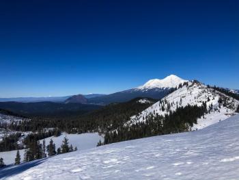
One of my personal favorite framings of Mount Shasta...Top of Green Butte looking north along Green Butte Ridge, Avalanche Gulch left and a portion of the Old Ski Bowl right.
[Photo: Koster]
Recent Observations
- Northwest wind really turning on at 1400 last night, increasing this morning, blowing steady 25-35 mi/hr with gusts 50-60 mi/hr.
- Spring like snow surface conditions on southerly slopes, lower elevations and on the west side.
- Northerly and less sunny aspects remain variable, a patchy mix of hard wind drifts, crust and sastrugi features.
- Little to no snow is available for wind drifting in ridgetop areas.
- Mount Shasta has been pounded by wind and remains scoured.
- No sign(s) of avalanche danger
- Average snow depths - Mount Shasta: 4.5-5.5 feet / Castle Lake: 2-3 feet / Eddy Range: 3-4 feet
Weather and Current Conditions
Weather Summary
A skosh of precipitation is falling across portions of southern Oregon. Northern California remains mostly dry for now...today a few very light snow showers are possible with chilly temps driving snow levels down to near 2,000 feet. Little to no accumulation is expected and the low pressure system will move eastward by this evening. In my humble opinion, it will most likely remain clear, sunny and windy today for Mount Shasta....with more of that in the near future as well. Tonight cold temperatures arrive. A ridge of high pressure pushes in next week hosting warm and dry weather until Thursday, our next best chance at precipitation.
24 Hour Weather Station Data @ 5:00 AM
| Weather Station | Temp (°F) | Wind (mi/hr) | Snow (in) | Comments | ||||||||
|---|---|---|---|---|---|---|---|---|---|---|---|---|
| Cur | Min | Max | Avg | Avg | Max Gust | Dir | Depth | New | Water Equivalent | Settlement | ||
| Mt. Shasta City (3540 ft) | 40 | 32 | 60 | 44.5 | 5 | |||||||
| Sand Flat (6750 ft) | 34 | 34 | 47 | 40 | 50 | 0 | 0 | 0 | ||||
| Ski Bowl (7600 ft) | 38.5 | 34 | 47.5 | 39.5 | 66 | 0 | 0 | 1 | ||||
| Gray Butte (8000 ft) | 33.5 | 33.5 | 45 | 38.5 | 17 | 55 | NW | |||||
| Castle Lake (5870 ft) | 26 | 26 | 52.5 | 40.5 | 31 | 0 | 0 | |||||
| Mount Eddy (6509 ft) | 23.5 | 23.5 | 47.5 | 39 | 2 | 10 | ESE | 48 | 0 | 0 | ||
| Ash Creek Bowl (7250 ft) | down | |||||||||||
| Ash Creek Ridge (7895 ft) | down |
Two Day Mountain Weather Forecast
Produced in partnership with the Medford NWS
| For 7000 ft to 9000 ft | |||
|---|---|---|---|
|
Saturday (4 a.m. to 10 p.m.) |
Saturday Night (10 p.m. to 4 a.m.) |
Sunday (4 a.m. to 10 p.m.) |
|
| Weather | Sunny and blustery | Mostly clear and blustery | Sunny |
| Temperature (°F) | 30 | 17 | 33 |
| Wind (mi/hr) | Northwest 10-15 | North 10-15 | Northeast 10-15 |
| Precipitation SWE / Snowfall (in) | 0.00 / 0 | 0.00 / 0 | 0.00 / 0 |
| For 9000 ft to 11000 ft | |||
| Saturday | Saturday Night | Sunday | |
| Weather | Sunny, windy | Clear, windy | Sunny, windy |
| Temperature (°F) | 29 | 10 | 27 |
| Wind (mi/hr) | Northwest 45-55 | North 30-40 | Northeast 40-50 |
| Precipitation SWE / Snowfall (in) | 0.00 / 0 | 0.00 / 0 | 0.00 / 0 |
Season Precipitation for Mount Shasta City
| Period | Measured (in) | Normal (in) | Percent of Normal (%) |
|---|---|---|---|
| From Oct 1, 2024 (the wet season) | 12.90 | 23.97 | 54 |
| Month to Date (since Apr 1, 2025) | 0.12 | 1.70 | 7 |
| Year to Date (since Jan 1, 2025) | 3.97 | 8.76 | 45 |


