

You are here
Avalanche Advisory for 2015-04-11 06:28:41
- EXPIRED ON April 12, 2015 @ 6:28 amPublished on April 11, 2015 @ 6:28 am
- Issued by Nick Meyers - Shasta-Trinity National Forest
Bottom Line
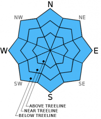
The avalanche danger is LOW for all aspects and elevations.
Be careful of shallow buried objects just below new snow.
Carry a beacon, shovel and probe and continue to use safe travel techniques.


Avalanche Problem 1: Normal Caution
-
Character ?

-
Aspect/Elevation ?
-
Likelihood ?CertainVery LikelyLikelyPossible
 Unlikely
 -
Size ?HistoricVery LargeLargeSmall

Spring time is here. This means the chance for warm, sunny days resulting in wet-loose related avalanche activity or a late season storm or wind event quickly causing the avalanche danger to rise with storm and/or wind slabs. Be observant for it all!
Human triggered slides are unlikely on all aspects and elevations today.
Variable conditions will be found on the mountain: scoured to old snow on ridgelines, heavy powder, breakable crust, wind drifts. Don't twist your knee!
Recent Observations
The snowpack continues to settle and stabilize. Yesterday, north, south, east and west aspects were tested with extended column tests... the results were only a sore hand (ECTX-no fracture). Four hundred plus pound snowmobiles have also certainly been testing the water over the week with no incidents. Snow depths were 15 to 30 inches consolidated, new snow in the 9,000 to 10,000 foot levels. At 7,600 feet in the Old Ski Bowl, we currently have 88 inches of snow on the ground.
While one might think 2 feet of new snow would provide for some great skiing, in fact the conditions have been variable and less than ideal. While not widespread, a thin crust can be found in open, sun affected areas at lower elevations. Cooler, shadier areas at lower elevations hold heavier powder. Above treeline and on the upper mountain, dryer snow with an occaisonal crust and deeper drifts will be encountered. Ridge lines are scoured to the old snow in some areas, but not consistent for good ridge climbing and thus post-holing is an issue. It's a mixed bag overall and it will take a week or so for all the new snow to work toward a melt/freeze cycle and corn skiing to return.
We've got the overall avalanche danger as low with no one avalanche problem rearing its head. Use normal caution and make solid observations as you choose your route up and down the mountain. We often see climbers attempting Shasta this time of year and they do not bring a beacon, shovel and probe. We highly recommend having this equipment and knowing how to use it. Wet loose related avalanche activity is common in the spring time on Shasta. Further, a late season storm can quickly cause the avy danger to rise while on your climb. Both The Fifth Season and Shasta Base Camp can rent this equipment if you do not own it.
Climbing Mt. Shasta this weekend: All routes on the mountain are currently in great shape, however with the several feet of new snow over this past week, post holing will be a problem where significant accumulation has occured. If one chooses to come up onto Shasta, ski's, snowshoes or splitboard are advised! Winter storms are still possible this time of year so please be prepared. Today, the skies are cloudy with light precip/snow expected and increasing winds. This will make summiting unlikely.
Castle Lake and Mt Eddy zones are still hosting a shallow snowpack. All areas below about 6,000 feet in the forecast area are hosting patchy, if any snow with dirt showing around trees and in sunny spots. For Castle Lake, skiing is out of the question at this point due to lack of snow.
Report your observations to the MSAC! A photo, a few words... send them in! (nimeyers@fs.fed.us or 530-926-9614)
Sand Flat Winter Trails: OPEN, however snow depths are meager and the Lower Sand Flat road is exposed dirt. We recommend heading up to Bunny Flat and touring up the road or anywhere higher in elevation!
Pilgrim Creek Snowmobile Park: CLOSED due to lack of snow
-------------------------------------------------------------------------------------------------------------------------------
Terrain: Remember most of the terrain that we like to play on is greater than 30 degrees. Avalanches are possible on anything steeper than 30 degrees. Avoid cornices, rock bands, terrain traps and runout zones of avalanche paths.
Weather: Most of our areas avalanche danger will occur 24-48 hours after a storm. We still can see persistent weak layers from time to time and we always will be sure to let you know about that! Heed the basic signs: Wind (significant snow transport and depositions), Temperature (rain/snow/rain/snow, which in turn weakens the snowpack), and Precipitation (Snow or rain add weight and stress to the current snowpack).
Snowpack: If snow accumulates, give the snowpack a chance to adjust to the new snow load before you play on or near steep slopes (greater than 30 degrees). Most direct action avalanches occur within 24-48 hours of recent snowfall. Watch for obvious signs of snowpack instability such as recent natural avalanche activity, collapsing of the snowpack (often associated with a “whumphing” sound), and shooting cracks. If you see these signs of instability, limit your recreation to lower angle slopes.
Human Factor: Don’t forget to carry and know how to use avalanche rescue gear. You should NOT be skiing or climbing potential avalanche slopes without having beacons, shovels, and probes. Only one person in a group should be exposed to potential avalanche danger at a time. Remember, climbing, skiing, and riding down the edge of slopes is safer than being in the center. Just because another person is on a slope doesn't’t mean that it is safe. Be an individual! Make your own decisions. Heed the signs of instability: rapid warming, “whumphing” noises, shooting cracks, snowing an inch an hour or more, rain, roller balls, wind loading, recent avalanche activity.
The Five Red Flags of Avalanche Danger any time of year include: 1) Recent/current avalanche activity 2) Whumpfing sounds or shooting cracks 3) Recent/current heavy snowfall 4) Strong winds transporting snow 5) Rapid warming or rain on snow.
Weather and Current Conditions
Weather Summary
In Mt Shasta City this morning at 0500, we have cloudy skies and a current temperature of 45 F degrees with calm winds.
WEATHER STATION INFORMATION (0500hrs):
On Mt Shasta (South Side) in the last 24 hours...
Old Ski Bowl - 7,600 feet, the current temperature is 30 F. Snow on the ground totals 88 inches with 2 inches settlement. Storm total over the week (Monday/Tuesday) was about 2 feet, though has settled over 13 inches at this weather station since then. Temperatures have ranged from 29 F to 43 F.
Gray Butte - 8,000 feet, the current temperature is 28 F. Temps have ranged from 28 F to 37 F. Winds have been westerly in direction, averaging 5-15 mph with gusts to 28 mph, WNW.
Castle Lake and Mt Eddy (West side of Interstate-5)...
Castle Lake - 5,600 feet, the current temperature is 36 F. Temps have ranged from 31 F to 55 F. The Castle Lake area received 6-8 inches of snow over the week (Monday/Tuesday) and has settled down to about 1-2 inches. There is overall very little snow at Castle Lake and skiing is not possible.
Mt Eddy - 6,500 feet, the current temperature is 33 F. Temps have ranged from 30 F to 43 F. Current snow depth is 15 inches with 3 inches settlement. The Mt Eddy area received 1-2 feet of new snow over the week (Monday and Tuesday). Winds have been southerly in direction, averaging 1-3 mph with gusts to 15 mph, SE.
WEATHER SYNOPSIS: Perhaps this last storm was the last push for winter for the season. Naturally, we are not ruling out any future storms for this year, however the weather looks to be trending spring-like. The small storm expected for today is exactly that thus far. We are seeing some clouds currently as the majority of the storm moves across Oregon, to the north of us. Mt Shasta may get some very light precip from the southern edge of the system today, but nothing to get your Gore-tex out for. Winds will pick up into the 20-30 mph range and out of the west and decrease tomorrow. Sunday looks to be clear and a very nice day!
THIS SEASON PRECIPITATION: Since October 1st (the wet season) , we have received 32.77 inches of water, normal is 36.58 inches, putting us at 89% of normal. For the month of April, we sit at 1.34 inches of water, normal is 1.12, putting us at 119% of normal. For the year of 2015, we've received 13.25 inches water, normal is 21.37, equalling 62% of normal.
Snow Survey Results for April 2015 for the Sacramento, Shasta and Trinity Watersheds: 24% of normal, with water content at 26%, and an average depth of 20 inches. Historic average for snow is 83 inches. Last year at this time we were 28% of normal. Similar years to this year are 1936, 1977, 1988, 1994. More concerning is the McCloud area snowpack where there is no measurable snow. For the first time since 1945, the first year snow surveys were started on the McCloud river watershed, the survey courses were 0% of normal. The majority of southern Siskiyou County's current snowpack exists above 7,000 feet. Snow above this elevation actually show a favorable increase from last year. However, after the 4th year of below average snowpack and with no current snowpack in the lower elevations, the drought will have serious implications to water supplies and on the health of natural resources and wildlife.
Always check the weather before you attempt to climb Mt Shasta. Further, monitor the weather as you climb. Becoming caught on the mountain in any type of weather can compromise life and limb. Be prepared.
| 0600 temperature: | 30 |
| Max. temperature in the last 24 hours: | 43 |
| Average wind direction during the last 24 hours: | Westerly |
| Average wind speed during the last 24 hours: | 5-15 mi/hr |
| Maximum wind gust in the last 24 hours: | 28 mi/hr |
| New snowfall in the last 24 hours: | 0 inches |
| Total snow depth: | 88 inches |
Two Day Mountain Weather Forecast
Produced in partnership with the Medford NWS
| For 7000 ft to 9000 ft | |||
|---|---|---|---|
|
Saturday (4 a.m. to 10 p.m.) |
Saturday Night (10 p.m. to 4 a.m.) |
Sunday (4 a.m. to 10 p.m.) |
|
| Weather | Slight chance of snow showers before 11am, then rain and snow showers, cloudy, becoming mostly sunny | Mostly clear | Sunny |
| Temperature (°F) | 44 | 29 | 53 |
| Wind (mi/hr) | West 10-20 mph | North/northwest 5-15 mph | North/northeast 5-10 mph |
| Precipitation SWE / Snowfall (in) | / 0-.5 | / 0 | / 0 |
| For 9000 ft to 11000 ft | |||
| Saturday | Saturday Night | Sunday | |
| Weather | A 40% chance of snow showers mainly before 11am, cloudy through mid morning and then gradually clearing | Mostly clear | Sunny |
| Temperature (°F) | 48 | 30 | 53 |
| Wind (mi/hr) | West 20-30 mph | Northwest 0-.5 | West 15-20 mph |
| Precipitation SWE / Snowfall (in) | / 0-.5 | / 0 | / 0 |

