

You are here
Avalanche Advisory for 2016-03-28 06:19:03
- EXPIRED ON March 29, 2016 @ 6:19 amPublished on March 28, 2016 @ 6:19 am
- Issued by Jon Dove - Shasta-Trinity National Forest
Bottom Line
LOW avalanche danger exists for all elevations and aspects across the forecast area. Sun shine and warm temperatures have helped wind slabs continue to bond with underlying snow, and are becoming less sensitive to trigger. Above treeline, in the typical starting zones, on slopes 37 degrees and steeper will be where one might find lingering slabs. Cold temperatures today will limit any loose wet instabilities. Evaluate snow and terrain carefully looking for unstable snow on isolated terrain features.


Avalanche Problem 1: Normal Caution
-
Character ?

-
Aspect/Elevation ?
-
Likelihood ?CertainVery LikelyLikelyPossible
 Unlikely
 -
Size ?HistoricVery LargeLargeSmall

We have reached the time of year where the sun has a higher arc across the sky, and daytime temperatures are warming to levels that promote consolidation and bonding within the snowpack. Snow conditions were reported to be firm in the morning hours, but by early afternoon the top 1-2 inches of snow had softened up. We will continue on the melt/freeze cycle for the duration of the work week. For today Normal Caution is advised. Cool daytime temperatures will prevent widespread loose wet snow instabilities from affecting the forecast area. There may be a roller ball or pinwheel scattered about below treeline on southerly facing aspects, but they will be of little consequence. That being said, the danger for loose wet slides will increase over the coming days as high pressure builds allowing for lots of sunshine and steadily increasing temperatures. Danger for wind slabs is decreasing. They may remain, however, at higher elevations (above 10,000 feet) along ridge tops, around rock outcroppings, the tops of chutes, and depressions. They will be most apt to be triggered on slopes 37 degrees and steeper on S-SE-E-NE aspects. Low avalanche danger is not a green light for complacency. Continue to practice safe backcountry travel techniques!
Forecast Discussion
An upper level trough and the associated cold front are moving southeast over the area this morning. Light snow showers brought trace amounts of new snow to parts of the forecast area. We may see a lingering snow shower or two today as the trough leaves the region. A high pressure ridge will begin to build over head beginning a warming and drying trend. Expect sunshine and steadily increasing temperatures through Friday. Blustery north winds today will persist through Tuesday with ridge tops and exposed areas above treeline seeing wind speeds of 35-50 mph with occasional higher gusts. Good visibility will draw climbers and skiers/riders toward the upper elevations for summit attempts and ski descents. Winds will be a factor, the snow will be firm and smooth in the morning, and rime ice fall will be present as well. We are on the edge of climbing season for Mount Shasta, and full winter mountaineering conditions exists. Have the proper equipment (mountain axe, crampons, helmet, avalanche transceiver, shovel, and probe) and know how to use it!
THIS SEASON PRECIPITATION for MT SHASTA CITY: Since October 1st (the wet season), we have received 36.73 inches of water, normal is 34.93 inches, putting us at 105% of normal. For the month of March we've received 11.21 inches of water, normal is 5.43 inches, putting us at 206% of normal, and finally... for the year of 2016 we've received 27.24 inches of water, normal is 19.72 inches, putting us at 138% of normal.
Recent Observations
Skies remained mostly sunny through the day yesterday and temperatures warmed to comfortable levels across the forecast area. The snow up on Mount Shasta was reported to be firm in the morning hours, but the top 1-2 inches softened by the afternoon. It is uncertain as to how high in elevation the softening of the snow's surface occurred. Areas such as Castle Lake and Sun Bowl probably produced good corn snow conditions for skier and riders. Cooler temperatures today may keep snow on the firm side at elevations of 6,500 feet and above meaning lower elevation zones like Castle Lake may be a better option today for corn snow. As the week progresses sun shine and daily warm temperatures coupled with overnight refreeze will promote consolidation of the snow and produce decent corn conditions at progressively higher elevations. This will make zones such as Sun Bowl, Powder Bowl and lower Avalanche Gulch prime spots to find corn snow to slide on. This will also mean the increase of avalanche danger in the form of loose wet snow avalanches, roller balls, pinwheels, and point release wet slides. These instabilities will be most present on southerly facing aspects during the warmest parts of the day. While usually not much of a hazard themselves, they could entrain enough snow to knock a person off of their feet and push them over a cliff, into rocks or trees, or potentially bury you in a terrain trap. Wind slabs that developed since our last snow storm have had time to bond with underlying snow, but some may still exist out there at higher elevations (above 10,000 feet). Lingering slabs will be most likely to be triggered on S-SE-E-NE facing aspects, slopes 37 degrees and steeper. Look for clues that might indicate a remaining slabs presence such as cornices, or firm rounded snow with a hollow sound.
Observations made at Castle Lake several days ago noted melting lake edges. This is actually a serious concern... if one gets caught or knocked off their feet in any type of avalanche, and the slide makes it's way down to lake level you could possibly be pushed through thin ice and into the lake. It would be difficult if not impossible to perform a rescue in those conditions. In other words, melting lake edges are horrible terrain traps! Be careful up there.
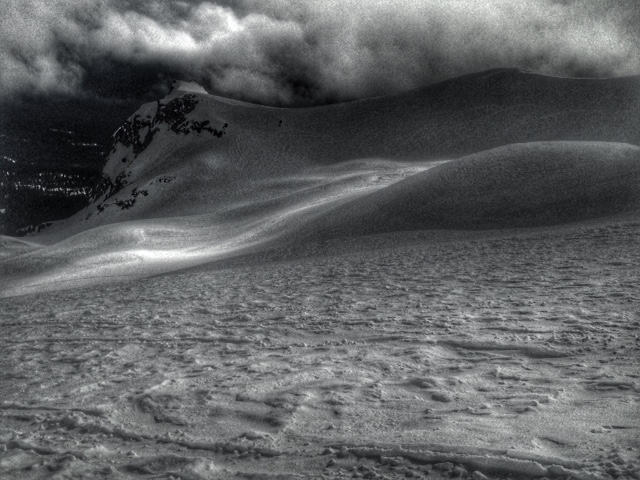
The snow's surface up in Old Ski Bowl. Note the wind's affect on the snow's surface forming sastrugi (3-26-2016):
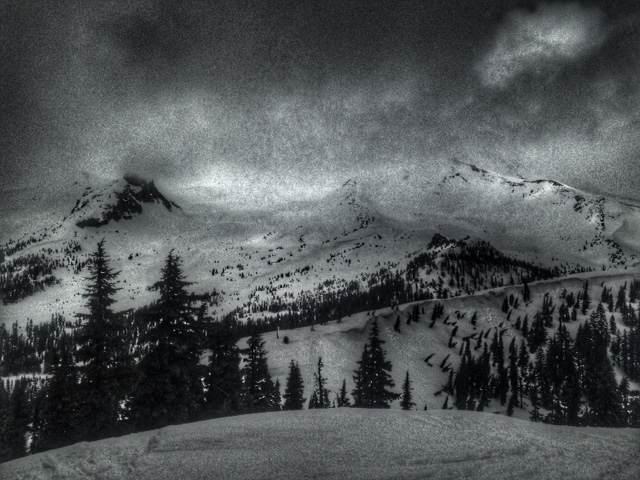
View up into Old Ski Bowl from the top of Gray Butte. Note the cornices that have formed on the top of SE facing ridge line (3-26-2016):
A note for all climbers and skiers heading up onto the upper mountain: Rime ice has formed on most rock outcroppings and is currently very thick. As warm days ensue, rime ice will flake off and fall down onto the slopes below. Rime ice chunks can be very large and very hard, enough to potentially kill you or cause serious injury. Beware of this hazard. Keep your eyes up slope as you climb and move laterally to avoid falling chunks of ice. If continuous ice fall is encountered turn around and descend to climb another day!
-----------------------------------------------------------------------------------------------------------------------------------------------------------
LOCAL AREA ROAD, NORDIC, AND SNOWMOBILE PARK STATUS:
The Sand Flat cross country ski trails are in good shape and ready for your cross country skis and snow shoes. These are backcountry routes marked with blue diamonds on trees. Trails are not groomed. Snow shoers, please blaze a parallel trail to cross country skiers staying out of the skin track. These trails can be accessed via the Everett Memorial Highway. Thank you, and enjoy!
The Mt. Shasta Nordic Center is open! These beautiful, groomed trails can be accessed via the Ski Park Highway. http://www.mtshastanordic.org
The Pilgrim Creek & Deer Mountain Snowmobile Parks are open! Trails have not been groomed in the past week and a half due to constant deep snow fall. Head to our "Education" tab on our website and find the snowmobile section for trail information, grooming status, and other sledder resources.
The Castle Lake Road is OPEN. The Everett Memorial Highway is OPEN. The Castle Lake and Everett Hwy are plowed year round to the trailheads. The roads are not always first priority, so your dawn patrol powder mission might be ceased if the plow has not made it up yet. Siskiyou County does a great job keeping the roads clear and be respectful of the plow drivers if you encounter them. If you get to Bunny Flat before or during when the plow is there, please park on the uphill, LEFT side of the parking lot as you drive in. This is uphill and lookers right of the bathrooms. Thank You!
The Five Red Flags of Avalanche Danger any time of year include: 1) Recent/current avalanche activity 2) Whumphing sounds or shooting cracks 3) Recent/current heavy snowfall 4) Strong winds transporting snow 5) Rapid warming or rain on snow.
Weather and Current Conditions
Weather Summary
Good Morning! In Mt Shasta City at 0500, we have a current temperature of 32 F, ten degrees cooler than yesterday at this time. Skies are partly cloudy with moderate NW wind.
On Mt Shasta (South Side) in the last 24 hours...
Old Ski Bowl - 7,600 feet, the current temperature is 16 degrees F. Snow on the ground totals 149 inches with a trace of new snow and 4-5 inches of settlement. Temperatures have ranged from 16 F to 41 F.
Gray Butte - 8,000 feet, the current temperature is 15 degrees F. Temperatures have ranged from 15 F to 35 F. Wind speeds will not be available for Gray Butte. The anemometer was taken down due to the need for repairs. Thank you for your understanding.
Mt Eddy Range (West side of Interstate-5)...
Castle Lake - 5,600 feet, the current temperature is 21 degrees F. Temperatures have ranged from 21 F to 48 F. Snow on the ground totals 72 inches with no new snow and 1 inch of settlement.
Mt Eddy - 6,500 feet, the current temperature is 17 degrees F. Temperatures have ranged from 17 F to 40 F. Snow on the ground measures 87 inches with 3 inches of new snow and little settlement. Winds have been southeasterly in nature with an average of 3 mph, and a maximum gust of 14 mph, SE.
Always check the weather before you attempt to climb Mt Shasta. Further, monitor the weather as you climb. Becoming caught on the mountain in any type of weather can compromise life and limb. Be prepared.
| 0600 temperature: | 22 |
| Max. temperature in the last 24 hours: | 43 |
| Average wind direction during the last 24 hours: | N/A |
| Average wind speed during the last 24 hours: | N/A mi/hr |
| Maximum wind gust in the last 24 hours: | N/A mi/hr |
| New snowfall in the last 24 hours: | 0 inches |
| Total snow depth: | 98 inches |
Two Day Mountain Weather Forecast
Produced in partnership with the Medford NWS
| For 7000 ft to 9000 ft | |||
|---|---|---|---|
|
Monday (4 a.m. to 10 p.m.) |
Monday Night (10 p.m. to 4 a.m.) |
Tuesday (4 a.m. to 10 p.m.) |
|
| Weather | Partly sunny with a 30% chance of snow showers. | Partly cloudy with a 20% chance of snow showers. Blustery | Mostly sunny. A 20% chance of snow shower before 11 am. |
| Temperature (°F) | 31 | 22 | 39 |
| Wind (mi/hr) | North 10-20 mph | North 15-20 mph | North 10-20 mph |
| Precipitation SWE / Snowfall (in) | / 1-2 | / 0 | / 0 |
| For 9000 ft to 11000 ft | |||
| Monday | Monday Night | Tuesday | |
| Weather | Partly sunny and cold with 30% chance of snow showers. Windy with wind chill values as low as -22 | Partly cloudy with a 20% chance of snow showers. Windy with wind chill values as low as -18 | Mostly sunny with a 20% chance of snow showers before 11 am. Windy with wind chill values as low as -18 |
| Temperature (°F) | 8 | 8 | 14 |
| Wind (mi/hr) | North 25-30 mph with gusts to 40 mph | North 1-3 | Northeast 35-40 mph |
| Precipitation SWE / Snowfall (in) | / 1-3 | / 0 | / 0 |

