

You are here
Avalanche Advisory for 2017-01-11 07:09:45
- EXPIRED ON January 12, 2017 @ 7:09 amPublished on January 11, 2017 @ 7:09 am
- Issued by Nick Meyers - Shasta-Trinity National Forest
Bottom Line
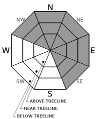
Today, CONSIDERABLE avalanche can be expected near and above treeline and MODERATE danger below treeline. Wind slabs and unstable cornice features were abundant yesterday and are likely to continue today. Clearing skies may lure backcountry riders into above treeline terrain where observations have been limited. Proceed with caution. Feet of new snow and west/southwest winds have created a combination of avalanche problems, each of which could produce large avalanches.


Avalanche Problem 1: Wind Slab
-
Character ?

-
Aspect/Elevation ?
-
Likelihood ?CertainVery LikelyLikelyPossible
 Unlikely
 -
Size ?HistoricVery LargeLargeSmall

Over the past week, several feet of new snow has fallen and wind transport of new snow has been in its prime. Steady 25-30 mph west/southwest wind has been blowing over the past 4 days and is expected to continue today. Wind slabs have been observed at all elevation bands, but most prevalent near and above treeline on NW-N-NE-E-SE aspects. Wind slabs could be small to large, several feet thick and should be your primary concern for today. Avoid traveling on or below slopes steeper than 30 degrees where wind loading has occurred.
Large, sensitive cornices have been forming along ridgelines presenting an additional hazard.
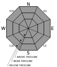
Avalanche Problem 2: Storm Slab
-
Character ?

-
Aspect/Elevation ?
-
Likelihood ?CertainVery LikelyLikelyPossible
Unlikely
-
Size ?HistoricVery LargeLargeSmall
We've seen 20 inches of new snow in the past 48 hours. Storm slabs are possible on all aspects and at all elevations, but most likely near treeline in more protected areas where wind effect has not been as great.
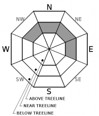
Avalanche Problem 3: Deep Slab
-
Character ?

-
Aspect/Elevation ?
-
Likelihood ?CertainVery LikelyLikelyPossible
Unlikely
-
Size ?HistoricVery LargeLargeSmall
A weak layer of snow was buried on 12/23 and a persistent slab problem has progressed toward a deep slab avalanche problem due to feet of new snow on top of these persistent weak grains of snow. This problem remains throughout the advisory area on NW-N-NE-E aspects near treeline.
There have been no reports of persistent slab avalanches occurring on the 12/23 layer. The distribution of this problem is isolated, and it primarily has been found on north facing, near treeline slopes. Evidence suggesting that the persistent slab avalanche problem exists is rare and hard to find. During the 01/08 rain on snow event, free water penetrated through the snowpack down to the 12/23 layer below treeline. This rain event, which has been followed by a significant cooling trend, may have erased the presence of the persistent slab avalanche problem at lower elevations. That said, we do not have enough evidence to support the removal of this avalanche problem. The now deep slab avalanche problem continues to pose a concern as the snowpack adjusts to feet new snow and added weight. If an avalanche were to be triggered or step down to this layer, a large and destructive avalanche would result.
Forecast Discussion
The snowpack will continue to adjust to rapid accumulation of new snow. One could encounter sensitive wind slabs, large cornice features, storm slabs and unlikely but possible deep slab instability today. Observations have been few above treeline due to poor weather and visibility. As the skies clear over the next several days, one will need to proceed with caution. Large avalanches are possible and will certainly pose a threat to human life. Don't become a statistic.
Recent Observations
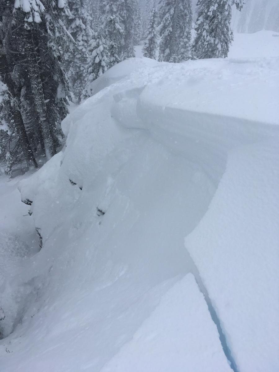
Weak cornices and wind slabs were the primary avalanche problems yesterday. Numerous observations came in of easily triggered cornice failures and subsequent wind slab failure within new snow layers. The Mt Shasta Ski Park backcountry ski coordinator reported controlled ski cuts on test slopes and small features to have produced avalanches on all aspects within Ski Park boundaries. This photo below is on a SE aspect at 6,000 feet. (Also see the Gray Butte observation with photos by our professional observer.)
Winds have been blowing steady, 25-30 mph out of the west/southwest for the past 48 hours. Out of bounds, observations on Gray Butte yesterday reported wild weather, whipping winds and wind slab and cornice formation galore at all elevation bands. The Old Ski Bowl weather station has received 10 inches of new snow in the last 24 hours and 20 inches in the last 48 hours. One recreational rider described his outing yesterday as, "sketch-ball dude"! All failures have occured on top of the 1/8 rain event layer. This layer is about 6 cm thick and widespread on all aspects and elevations up to about 8,000 feet. Late in the day, temperatures rose a few degrees as did snow levels, upwards of about 6-6,500 feet.
While instability was observed on all aspects yesterday, most notable wind loading and cornice formation was on north, northeast and east aspects. Storm slab instability was not notable, but it's likely that with all the new snow, a storm slab could be triggered by a rider somewhere within the forecast area. Expect all the same type of instability today: Cornices, wind slabs and perhaps a storm slab!
Weather and Current Conditions
Weather Summary
Today we should be able to keep our heads above water as the latest atmospheric river diminishes. The NWS Winter Weather Advisory expires at 10am this morning. Snow showers will be scattered throughout the day but overall we enter a drying trend for the next several days. This will allow localized flooding to subside and for folks to clean up a few messes! If you expereinced any issues with the buckets of rain and snow this week, be prepared for next week. Forecasts predict another similar type event to bring prolonged precipitation, sometime near next Tuesday.
For today, lingering snow showers with falling temperatures. Snow levels will be to Mt Shasta City and perhaps as low as 1,500 feet as cold air pushes in. Precipitation models are calling for another .30 inches of water, which could mean another couple inches of snow. Overall, the low pressure that has been shoving water down our throats will begin to move east and clearing skies will prevail. Winds will continue out of the southwest today though also begin to die off tonight into tomorrow, switching to east/northeast.
===========================================================
In Mt Shasta City at 0500, we have a current temperature of 34 F with cloudy skies and light snow.
On Mt Shasta (South Side) in the last 24 hours...
Old Ski Bowl - 7,600 feet, the current temperature is 18 degrees F. Temperatures have ranged from 18 F to 28 F. Snow on the ground totals 121 inches with 10 inches of new snow.
Grey Butte - 8,000 feet, the current temperature is 20 degrees F. Temperatures have ranged from 20 F to 27 F. Winds have averaged 25-30 mph with gusts to 56 mph, blowing out of the west/southwest.
Mt Eddy Range (West side of Interstate-5)...
Castle Lake - 5,600 feet, the current temperature is 25 degrees F. Temperatures have ranged from 25 F to 31 F. Snow on the ground totals 60 inches with 10 inches of new snow.
Mt Eddy - 6,500 feet, the current temperature is 23 degrees F. Temperatures have ranged from 23 F to 31 F. Snow on the ground measures 68 inches with 11 inches of new snow. Winds have averaged 1-2 mph with gusts to 15 mph, blowing out of the southwest to southeast.
THIS SEASON PRECIPITATION for MT SHASTA CITY: Since October 1st (the wet season), we have received 28.19 inches of water, normal is 17.60 inches, putting us at 160% of normal. For the month of January and for the year of 2017, we received 7.03 inches of water, normal is 2.39 inches, putting us at 294% of normal.
Always check the weather before you attempt to climb Mt Shasta. Further, monitor the weather as you climb. Becoming caught on the mountain in any type of weather can compromise life and limb. Be prepared.
| 0600 temperature: | 25 |
| Max. temperature in the last 24 hours: | 32 |
| Average wind direction during the last 24 hours: | West/Southwest |
| Average wind speed during the last 24 hours: | 10-15 mi/hr |
| Maximum wind gust in the last 24 hours: | 30 mi/hr |
| New snowfall in the last 24 hours: | 9 inches |
| Total snow depth: | 69 inches |
Two Day Mountain Weather Forecast
Produced in partnership with the Medford NWS
| For 7000 ft to 9000 ft | |||
|---|---|---|---|
|
Wednesday (4 a.m. to 10 p.m.) |
Wednesday Night (10 p.m. to 4 a.m.) |
Thursday (4 a.m. to 10 p.m.) |
|
| Weather | Snow showers. Chance of precipitation is 80%. . | Snow showers, mainly before 4am. Chance of precipitation is 80%. | A 30 percent chance of snow showers before 10am. Mostly sunny. |
| Temperature (°F) | Falling to 20 by 4pm | 16 | 27 |
| Wind (mi/hr) | South 5-15 | South/southwest 5-15 | North/Northeast 0-5 |
| Precipitation SWE / Snowfall (in) | / 2-4 | / 2-4 | / 0-.5 |
| For 9000 ft to 11000 ft | |||
| Wednesday | Wednesday Night | Thursday | |
| Weather | Snow showers. Wind chill values as low as -19. Windy, Chance of precipitation is 80%. | Snow showers, mainly before 4am. Wind chill values as low as -17. Chance of precipitation is 80%. | A 30 percent chance of snow showers before 10am. Mostly sunny. Wind chill values as low as -9. |
| Temperature (°F) | 6 | 5 | 11 |
| Wind (mi/hr) | West/Southwest 20-30 mph | Southwest 2-4 | East/Northeast 5-10 mph, increasing in the afternoon. |
| Precipitation SWE / Snowfall (in) | / 2-4 | / 2-4 | / 0-.5 |

