

You are here
Avalanche Advisory for 2017-03-28 06:33:11
- EXPIRED ON March 29, 2017 @ 6:33 amPublished on March 28, 2017 @ 6:33 am
- Issued by Andrew Kiefer - Mt Shasta Avalanche Center
Bottom Line
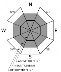
Near and above treeline, MODERATE avalanche danger exists. Strong and variable winds have created fresh wind slabs in leeward terrain, primarily on Mount Shasta between 9,000-12,000ft on easterly aspects. Natural avalanches are unlikely, while human triggered avalanches remain possible. Below treeline, the avalanche danger is LOW.


Avalanche Problem 1: Wind Slab
-
Character ?

-
Aspect/Elevation ?
-
Likelihood ?CertainVery LikelyLikelyPossible
 Unlikely
 -
Size ?HistoricVery LargeLargeSmall

Recent westerly winds have been the most productive in transporting the new snow and creating fresh wind slabs. Northwest winds were strong and steady for the majority of the day yesterday, but wind direction has become variable overnight. Wind slabs are most likely to be encountered on easterly aspects between 9,000-12,000ft on Mount Shasta, but all aspects near and above treeline should be assessed for the wind slab problem. Watch for blowing snow, cornice formation, and textured snow surfaces to help identify lee slopes and cross-loaded terrain features. Avoid wind-loaded slopes 35 degrees and steeper.
Recent Observations
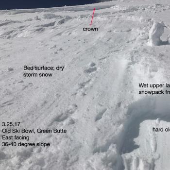
A notable wind event occurred at and above the 8,000ft level yesterday. Northwest winds remained steady at 20-30mph with gusts over 45mph for 6-8 hours beginning early yesterday morning. Plumes of snow were visible blowing off of ridge tops and cross loading terrain features in the alpine on Mount Shasta. Windward features have been significantly scoured in a short period of time, especially given the recent snowfall amounts. Wind direction shifted to the east/southeast and has been variable since yesterday afternoon. No avalanches were observed or reported yesterday. The snow received on Sunday and Monday settled close to 4 inches in most areas over the past 24 hours. The sun affected many snow surfaces yesterday afternoon as well.
Weather and Current Conditions
Weather Summary
A ridge of high pressure will bring clear and dry weather to the advisory area today. Strong north/northwest winds will continue at and above 10,000ft, and high temperatures will reach 40 degrees Fahrenheit at the 6,000ft level. The next system will begin to develop tonight. Under northwest flow, cloud cover will steadily increase overnight and into tomorrow. Light precipitation is set to arrive by tomorrow night and continue through Thursday. The storm should begin with high freezing levels near 8,500ft, but will lower to 5,000ft by Thursday. Cold air and very strong northwest winds will follow after the storm ends late in the week.
===========================================================
In Mt Shasta City at 0500, we have a current temperature of 39 F.
On Mt Shasta (South Side) in the last 24 hours...
Sand Flat - 6,750 ft, the current temperture is 29 degrees F. Temperatures have ranged from 23 F to 33 F. Snow on the ground totals 113 inches with no new snow and 4 inches of settlement.
Old Ski Bowl - 7,600ft. the current temperature is 21 degrees F. Temperatures have ranged from 20 F to 34 F. Snow on the ground totals 195 inches with no new snow and 4 inches of settlement.
Gray Butte - 8,000 feet, the current temperature is 22 degrees F. Temperatures have ranged from 17 F to 29 F. Winds have averaged 15-25 mph with gusts to 42 mph, blowing steadily out of the northwest yesterday and shifting to the east/southeast overnight.
Mt Eddy Range (West side of Interstate-5)...
Castle Lake - 5,800 feet, the current temperature is 28 degrees F. Temperatures have ranged from 23 F to 39 F. Snow on the ground totals 101 inches with no new snow and 3 inches of settlement.
Mt Eddy - 6,500 feet, the current temperature is 27 degrees F. Temperatures have ranged from 23 F to 33 F. Snow on the ground measures 99 inches with no new snow and 4 inches of settlement. Winds have averaged 1-4 mph with gusts up to 15 mph, blowing out of the southeast.
THIS SEASON PRECIPITATION for MT SHASTA CITY: Since October 1st (the wet season), we have received 49.15 inches of water, normal is 34.93 inches, putting us at 140% of normal. For the month of March, we have received 5.84 inches of water, normal is 5.43 inches, which is 108% of normal. And finally for the year of 2017, we received 27.99 inches of water, normal is 19.72 inches, putting us at 142% of normal.
Always check the weather before you attempt to climb Mt Shasta. Further, monitor the weather as you climb. Becoming caught on the mountain in any type of weather can compromise life and limb. Be prepared.
| 0600 temperature: | 29 |
| Max. temperature in the last 24 hours: | 33 |
| Average wind direction during the last 24 hours: | NW shifting ESE |
| Average wind speed during the last 24 hours: | 5-10 mi/hr |
| Maximum wind gust in the last 24 hours: | 15-20 mi/hr |
| New snowfall in the last 24 hours: | 0 inches |
| Total snow depth: | 113 inches |
Two Day Mountain Weather Forecast
Produced in partnership with the Medford NWS
| For 7000 ft to 9000 ft | |||
|---|---|---|---|
|
Tuesday (4 a.m. to 10 p.m.) |
Tuesday Night (10 p.m. to 4 a.m.) |
Wednesday (4 a.m. to 10 p.m.) |
|
| Weather | Mostly Sunny | Mostly Cloudy | Rain likely after 11am. Cloudy. Chance of precipitation 60%. |
| Temperature (°F) | 46 | 34 | 46 |
| Wind (mi/hr) | North 9-15 mph | North 8 mph | North 10 mph |
| Precipitation SWE / Snowfall (in) | / 0 | / 0 | / 0 |
| For 9000 ft to 11000 ft | |||
| Tuesday | Tuesday Night | Wednesday | |
| Weather | Mostly sunny and windy. | Mostly cloud and windy. | Mostly sunny and windy. |
| Temperature (°F) | 30 | 28 | 29 |
| Wind (mi/hr) | North/Northwest 34-39 mph | West/northwest 0 | West 25-30 mph |
| Precipitation SWE / Snowfall (in) | / 0 | / 0 | / 1-2 |

