

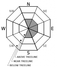
You are here
Avalanche Advisory for 2018-03-06 06:56
- EXPIRED ON March 7, 2018 @ 6:56 amPublished on March 6, 2018 @ 6:56 am
- Issued by Andrew Kiefer - Mt Shasta Avalanche Center
Bottom Line
Shallow wind slabs may form in isolated areas above treeline on S-SE-E-NE-N aspects today. Natural and human-triggered avalanches are unlikely. The avalanche danger is LOW at all elevations.


Avalanche Problem 1: Wind Slab
-
Character ?

-
Aspect/Elevation ?
-
Likelihood ?CertainVery LikelyLikelyPossible
 Unlikely
 -
Size ?HistoricVery LargeLargeSmall

Plenty of snow is available for transport, and westerly winds may create wind slabs above treeline on S-SE-E-NE-N aspects. Evidence of recent wind loading and the presence of wind slabs have been hard to find. That could change rapidly if westerly winds increase more than expected. Today, watch for blowing snow, hollow sounding snow and small cornices/wind lips as evidence of recent wind loading. Avoid the potential wind slab problem by sticking to sheltered or wind-scoured areas.
Forecast Discussion
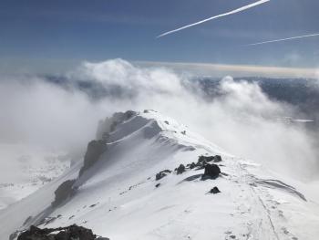
The snowpack has adjusted well to recent storm snow. No avalanches occurred on Mount Shasta during or following the storm, and no obvious signs of instability have been observed over the past 3 days. Shallow wind slabs may form in leeward terrain above treeline if westerly winds pick up today. Roller balls and pinwheels may continue on steep southerly slopes, but are not expected to pose a significant avalanche concern. A series of warm storms should begin late tomorrow night bringing continued precipitation through the weekend.
Recent Observations
Yesterday brought blue skies, warm sunshine and highs in the low 40s. Variable winds remained calm throughout the day. As of 3 am this morning, winds have organized to the WNW and increased in speed with a max gust of 21 mph recorded at the Grey Butte weather station.
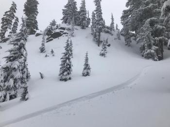
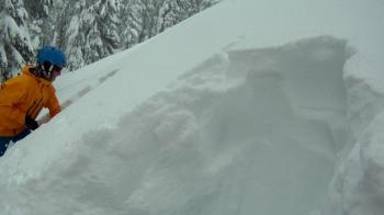
The new snow is right side up and well bonded to itself and the old snow surface. No wind slabs were visible on the south side of Mount Shasta during a tour to 9,800 ft in Giddy Giddy/Avalanche Gulch yesterday (View Observation). Previous wind loading had occurred above 8,000 ft on S-SE-E aspects leaving rippled and wavy snow surfaces. No active wind loading occurred yesterday. Roller balls and pinwheels occurred on steep SW-S-SE aspects but did not pose a concern. A thin sun crust formed on steep southerly slopes up to 8,000 ft as well.
Observations from Ash Creek Butte, Castle Lake and Mount Eddy have been limited. The Pilgrim Creek Snowmobile Park is open and has been recently groomed. Shallow snowpack hazards still likely exist in all three of these zones.

Weather and Current Conditions
Weather Summary
High pressure remains over the region. Expect sunshine today with increasing cloud cover in the afternoon. Highs will reach the mid 40s and light westerly winds will continue. The pattern will transition tomorrow as the first in a series of disturbances arrives from the southwest. Precipitation should begin late tomorrow afternoon with 2-4 inches of snow expected above 5,000 ft by Thursday morning. Snow levels will rise to 7,000 ft by the end of the week as rain and snow showers continue Thursday and Friday.
24 Hour Weather Station Data @ 6:00 AM
| Weather Station | Temp (°F) | Wind (mi/hr) | Snow (in) | Comments | ||||||||
|---|---|---|---|---|---|---|---|---|---|---|---|---|
| Cur | Min | Max | Avg | Avg | Max Gust | Dir | Depth | New | Water Equivalent | Settlement | ||
| Mt. Shasta City (3540 ft) | 24 | 17 | 46 | 32 | 1 | N | ||||||
| Sand Flat (6750 ft) | station down | |||||||||||
| Ski Bowl (7600 ft) | 31 | 14 | 55 | 31 | 60.5 | 0 | 0 | 2 | ||||
| Gray Butte (8000 ft) | 30.5 | 13 | 31 | 25 | 4 | 21 | WNW | |||||
| Castle Lake (5870 ft) | 31.5 | 20 | 41 | 30.5 | 30 | 0 | .5 | |||||
| Mount Eddy (6509 ft) | 27 | 10 | 34 | 25 | 3 | 6 | WSW | 46 | 0 | 1 | ||
| Ash Creek Bowl (7250 ft) | station down | |||||||||||
| Ash Creek Ridge (7895 ft) | station down |
Two Day Mountain Weather Forecast
Produced in partnership with the Medford NWS
| For 7000 ft to 9000 ft | |||
|---|---|---|---|
|
Tuesday (4 a.m. to 10 p.m.) |
Tuesday Night (10 p.m. to 4 a.m.) |
Wednesday (4 a.m. to 10 p.m.) |
|
| Weather | Sunny with increasing clouds | Mostly cloudy | Partly sunny and breezy. 80% chance of snow showers after 4pm. |
| Temperature (°F) | 42 | 36 | 41 |
| Wind (mi/hr) | E/NE 0-5 mi/hr | E/SE 5-10 mi/hr | S 10-15 mi/hr |
| Precipitation SWE / Snowfall (in) | / 0 | / 0 | / 0-1 |
| For 9000 ft to 11000 ft | |||
| Tuesday | Tuesday Night | Wednesday | |
| Weather | Sunny with increasing clouds | Mostly cloudy | Partly sunny and breezy. 80% chance of snow showers after 4pm |
| Temperature (°F) | 23 | 22 | 25 |
| Wind (mi/hr) | SW 10-20 mi/hr | S/SW 0 | S 20-30 mi/hr |
| Precipitation SWE / Snowfall (in) | / 0 | / 0 | / 0-1 |
Season Precipitation for Mount Shasta City
| Period | Measured (in) | Normal (in) | Percent of Normal (%) |
|---|---|---|---|
| From Oct 1, 2025 (the wet season) | 12.20 | 30.77 | 40 |
| Month to Date (since Mar 1, 2026) | 1.31 | 1.27 | 103 |
| Year to Date (since Jan 1, 2026) | 6.37 | 15.56 | 41 |

