

You are here
Avalanche Advisory for 2018-12-01 07:00
- EXPIRED ON December 2, 2018 @ 7:00 amPublished on December 1, 2018 @ 7:00 am
- Issued by Aaron Beverly - Mount Shasta Avalanche Center
Bottom Line
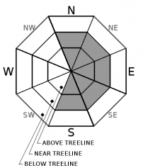
Expect avalanche danger to increase to MODERATE near and above treeline as moderate to strong winds continue to transport snow contributing to the formation of wind slabs on leeward slopes. Be cautious of hidden obstacles below snow surfaces and be prepared for cold temperatures and wind chills. Avalanche danger is LOW below treeline.


Avalanche Problem 1: Wind Slab
-
Character ?

-
Aspect/Elevation ?
-
Likelihood ?CertainVery LikelyLikelyPossible
 Unlikely
 -
Size ?HistoricVery LargeLargeSmall

The 18 inches of snow received since 11/28 has begun to be transported to easterly slopes by moderate to strong winds. This trend will continue today and wind slabs will continue to grow.
Evaluate snow and terrain carefully. Avoid wind slabs by traveling in windward areas where snow surfaces have been eroded. Avoid slopes greater than 35 degrees where wind loading has occurred. Evaluate conditions as you travel in safe terrain by looking for signs of the wind slab problem:
- Smooth rounded wind pillows
- Hollow sounding snow
- Harder snow atop softer snow
- Shooting cracks
Forecast Discussion
Ground surfaces have begun to fill in with new snowfall, but sliders and riders should still be cautious of hidden obstacles beneath the snow.
If venturing above treeline, bring appropriate clothing to protect from high winds and low temperatures and wind chills.
The Friends of the Mount Shasta Avalanche Center raised over $11,000 on giving Tuesday. Thank you to all who contributed to support this great community organization!
Recent Observations
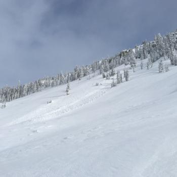
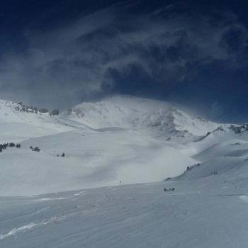
A series of winter storms beginning on Thanksgiving (November 22, 2018) has brought over 45 inches of snow above 7000 ft. Current height of snow (HN) at the Old Ski Bowl weather station is 43 inches. Observations yesterday saw wind affected snow in open areas, ridge tops, and westerly facing slopes near and above treeline. Moderate to strong NW winds were transporting snow to leeward slopes where thin wind slabs were forming.
Weather and Current Conditions
Weather Summary
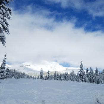
A low pressure system off the coast will continue to drive precipitation and cold air aloft into the area. A winter storm warning is in effect until 4 p.m. this afternoon. Expect 1-3 inches of snow today and a trace of snow tonight and tomorrow morning as drier conditions return for a couple of days. Wetter conditions will return by mid-week next week.
Snow levels will remain as low as 2500 ft throughout the weekend. Bundle up if venturing above treeline. Expect cold temperatures and even colder wind chills.
24 Hour Weather Station Data @ 4:00 AM
| Weather Station | Temp (°F) | Wind (mi/hr) | Snow (in) | Comments | ||||||||
|---|---|---|---|---|---|---|---|---|---|---|---|---|
| Cur | Min | Max | Avg | Avg | Max Gust | Dir | Depth | New | Water Equivalent | Settlement | ||
| Mt. Shasta City (3540 ft) | 32 | 32 | 45 | 36.5 | 2 | N | ||||||
| Sand Flat (6750 ft) | 25 | 22 | 29 | 26 | 31 | 1 | 0 | 2 | ||||
| Ski Bowl (7600 ft) | 21 | 20 | 27 | 22.5 | 42.8 | 2.6 | 0.13 | 2.1 | ||||
| Gray Butte (8000 ft) | 20.5 | 18.5 | 28 | 21.5 | 13 | 31 | NW | |||||
| Castle Lake (5870 ft) | station down | |||||||||||
| Mount Eddy (6509 ft) | 22.7 | 22.7 | 28 | 24 | 0 | 0 | 29.8 | 0 | 3 | |||
| Ash Creek Bowl (7250 ft) | station down | |||||||||||
| Ash Creek Ridge (7895 ft) | station down |
Two Day Mountain Weather Forecast
Produced in partnership with the Medford NWS
| For 7000 ft to 9000 ft | |||
|---|---|---|---|
|
Saturday (4 a.m. to 10 p.m.) |
Saturday Night (10 p.m. to 4 a.m.) |
Sunday (4 a.m. to 10 p.m.) |
|
| Weather | Snow showers, mainly before 4pm. Wind chill values as low as -21. Windy. Chance of precipitation is 100%. | A 60 percent chance of snow showers, mainly before 11pm. Mostly cloudy. Windy. Wind chill values as low as -19. | Mostly sunny and cold. Windy. |
| Temperature (°F) | 28 | 21 | 29 |
| Wind (mi/hr) | NW 11 | WNW 9 | NW 5 |
| Precipitation SWE / Snowfall (in) | / 1-3 | / < 1 | / < 0.5 |
| For 9000 ft to 11000 ft | |||
| Saturday | Saturday Night | Sunday | |
| Weather | Snow showers, mainly before 4pm. Wind chill values as low as -21. Windy. Chance of precipitation is 100%. | A 60 percent chance of snow showers, mainly before 11pm. Mostly cloudy. Windy. Wind chill values as low as -19. | Mostly sunny and cold. Windy. |
| Temperature (°F) | 12 | 8 | 11 |
| Wind (mi/hr) | W 36 | NW 2-4 | NW 15 |
| Precipitation SWE / Snowfall (in) | / 2-4 | / < 1 | / < 0.5 |
Season Precipitation for Mount Shasta City
| Period | Measured (in) | Normal (in) | Percent of Normal (%) |
|---|---|---|---|
| From Oct 1, 2023 (the wet season) | 4.73 | 7.36 | 64 |
| Month to Date (since May 1, 2024) | 4.16 | 5.08 | 82 |
| Year to Date (since Jan 1, 2024) | 20.01 | 35.36 | 57 |

