

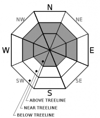
You are here
Avalanche Forecast for 2019-01-10 06:42
- EXPIRED ON January 11, 2019 @ 6:42 amPublished on January 10, 2019 @ 6:42 am
- Issued by Nick Meyers - Shasta-Trinity National Forest
Bottom Line
As skiers and riders step out into near and above treeline areas after the storm, it will be important to approach avalanche terrain with caution. The avalanche danger will increase as elevation is gained. Wind slabs remain the primary avalanche problem. Human triggered wind slabs are possible. Pay attention. Identify features of concern and move cautiously around areas where drifting snow is depositing, especially on or below slopes with cornice features or wind pillows.


Avalanche Problem 1: Wind Slab
-
Character ?

-
Aspect/Elevation ?
-
Likelihood ?CertainVery LikelyLikelyPossible
 Unlikely
 -
Size ?HistoricVery LargeLargeSmall

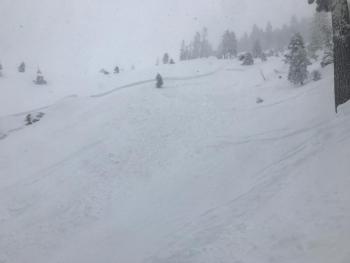
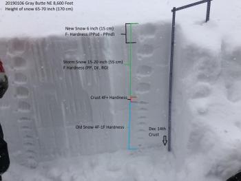
Due to lack of observations, uncertainty exists for the size, distribution and sensitivity of wind slabs. Several feet of new snow and strong wind has impacted the mountain over the past few days. Large, human triggered avalanches could still be possible. We think it's prudent to give the snowpack some respect and let it settle out one more day before testing steeper, wind loaded lines.
Wind has blown primarily from southeast to southwest, loading northerly slopes and cross-loading westerly and easterly slopes also. Wind slabs could be several feet thick. While wind slabs can appear stable, they can "pop" off without any notification and send one careening down the slope. Visual clues that indicate winds slabs are nearby include fresh cornices, blowing snow, snow drifts, and uneven snow surfaces.
Forecast Discussion
We are over the hump of the bell curve with regards to high avalanche danger. Terrain that is near or below the snow line and received rain on snow is of low concern. Rain on snow can cause immediate avalanche issues, but once the rain subsides, so does the avalanche danger. As for higher terrain, near and above treeline, uncertainty exists. As stated already, it will be important to use caution when stepping out into post storm, uncharted territory today. Human triggered avalanches could still be possible. Always watch for the 5 red flags of avalanche danger:
- Recent avalanche activity
- Cracking or whoomphing
- Significant snowfall in 24 hours
- Strong winds
- Rapid warming
Recent Observations
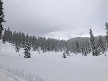
Precipitation began in earnest on the evening of Monday, January 7th and has not let up for most of the week. Since that time, almost 7 inches (6.94") of water has been recorded by the tipping bucket at the Old Ski Bowl weather station. Unfortunately, much of this precipitation was rain and heavy snow. We did get away with about 2-3 feet of fresh snow at lower elevations and likely twice that at upper elevations. Winds have blown from the east/southeast to west/southwest, averaging 15 mi/hr with gusts to 50+ mi/hr. The wet weather has tapered off yesterday afternoon and this morning. Access into near and above treeline terrain has been difficult due to road closures and poor visibility. A report from a snowmobiler who made it to Bunny Flat yesterday said they encountered very deep, wet and heavy snow and were getting stuck even in flat terrain. The wind was light and visibility was horrible. They did not ride past Bunny Flat. While we have no recent observations from near and above treeline terrain, judging by the sheer numbers (water amounts and snow totals), we are guessing that avalanches have occurred.
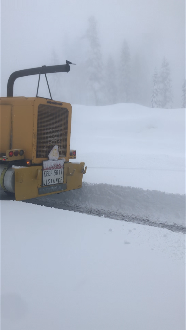
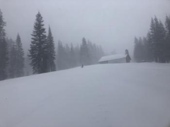
Siskiyou County rotary blower clearing the Bunny Flat parking lot yesterday, 1.9.19 / Photo: Garrett Austin
Weather and Current Conditions
Weather Summary
A progressive 5-wave pattern is showing on the northern hemispheric projection still, however the pattern will slow over the eastern Pacific and U.S. beginning Friday. A weak upper level trough is moving through the area now and scattered light showers are associated with it. We will see a break in precipitation today, as well as abating winds. A short wave will push a weak front onshore Friday afternoon bringing light precipitation to the area. Longer term, wet and unsettled weather is expected for the end of next week as a lot of energy begins to arrive via a strong cross-Pacific jet.
24 Hour Weather Station Data @ 5:00 AM
| Weather Station | Temp (°F) | Wind (mi/hr) | Snow (in) | Comments | ||||||||
|---|---|---|---|---|---|---|---|---|---|---|---|---|
| Cur | Min | Max | Avg | Avg | Max Gust | Dir | Depth | New | Water Equivalent | Settlement | ||
| Mt. Shasta City (3540 ft) | 38 | 29 | 38 | 34.5 | 1 | N | ||||||
| Sand Flat (6750 ft) | 31 | 31 | 32 | 32 | 72 | 6 | 1 | 1 | ||||
| Ski Bowl (7600 ft) | 26 | 26 | 30 | 28 | 85.5 | 7 | 2.43 | 2 | ||||
| Gray Butte (8000 ft) | 26 | 26 | 29.5 | 27 | 15 | 37 | SSW | |||||
| Castle Lake (5870 ft) | station down | |||||||||||
| Mount Eddy (6509 ft) | 29.5 | 29.5 | 32.5 | 31 | 1 | 12 | SSE | 60 | 10 | 2 | ||
| Ash Creek Bowl (7250 ft) | station down | |||||||||||
| Ash Creek Ridge (7895 ft) | station down |
Two Day Mountain Weather Forecast
Produced in partnership with the Medford NWS
| For 7000 ft to 9000 ft | |||
|---|---|---|---|
|
Thursday (4 a.m. to 10 p.m.) |
Thursday Night (10 p.m. to 4 a.m.) |
Friday (4 a.m. to 10 p.m.) |
|
| Weather | A 30% chance of rain and snow showers in the AM, otherwise becoming mostly sunny. Snow level near 5,500 feet. | Partly cloudy | Partly sunny, snow likely after 4p.m. Chance of precipitation 60%, Windy. |
| Temperature (°F) | 34 | 33 | 37 |
| Wind (mi/hr) | South/Southeast 10-15 | South/Southeast 5-10 | Southeast 5-10 |
| Precipitation SWE / Snowfall (in) | / 0-1 | / 0 | / 0 |
| For 9000 ft to 11000 ft | |||
| Thursday | Thursday Night | Friday | |
| Weather | A chance of snow showers in the AM. Mostly sunny and breezy. | Partly cloudy and breezy. | Partly sunny, windy. |
| Temperature (°F) | 23 | 23 | 26 |
| Wind (mi/hr) | Southwest 15-20 | South 0-1 | South 40-45 |
| Precipitation SWE / Snowfall (in) | / 0-1 | / 0 | / 0 |
Season Precipitation for Mount Shasta City
| Period | Measured (in) | Normal (in) | Percent of Normal (%) |
|---|---|---|---|
| From Oct 1, 2023 (the wet season) | 13.34 | 17.35 | 77 |
| Month to Date (since Apr 1, 2024) | 4.93 | 2.14 | 230 |
| Year to Date (since Jan 1, 2024) | 4.93 | 2.14 | 230 |

