

You are here
Avalanche Forecast for 2021-02-14 06:40
- EXPIRED ON February 15, 2021 @ 6:40 amPublished on February 14, 2021 @ 6:40 am
- Issued by Ryan Sorenson - Mount Shasta Avalanche Center
Bottom Line
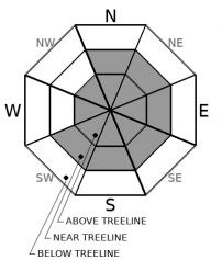
More snow and wind today will continue to add weight to a potentially fragile snowpack. Watch out for firm, fresh wind slabs resting on top of lower density snow. Natural avalanches are possible, and human-triggered avalanches are likely on steep, wind-loaded slopes. CONSIDERABLE avalanche danger remains in near/above treeline terrain and MODERATE danger exists below treeline.


Avalanche Problem 1: Wind Slab
-
Character ?

-
Aspect/Elevation ?
-
Likelihood ?CertainVery LikelyLikelyPossible
 Unlikely
 -
Size ?HistoricVery LargeLargeSmall

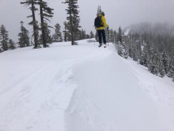
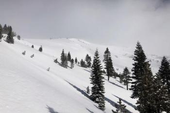
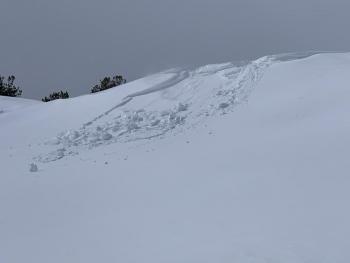
Strong W/NW winds continued to form fresh wind slabs and cornices yesterday. Expect existing wind slabs to be fragile as firm slabs over weaker softer snow have not had the time to bond to the underlying snow. Plenty of snow remains available for transport. Models predict more snowfall and wind today with rising snow levels. The additional snow and wind will increase the size and distribution of wind slabs. Slabs will be small to large-sized. Some natural wind slab avalanches are possible and human triggering likely on steep loaded terrain.
Look for clues such as blowing snow, cornices over slopes, ripples on the snow surface, and hollow sounding snow as you travel in safe terrain. Careful snowpack evaluation and conservative decision-making are necessary to avoid wind slab avalanches if you plan to step out into steeper terrain today. Be willing to step back if you see shooting cracks or whoomphing within the snowpack.
Recent Observations
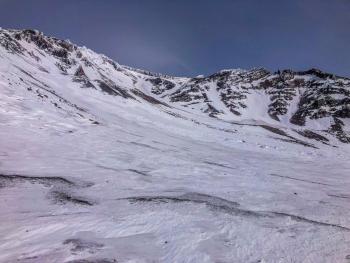
Two small storms, on Thursday night (2/11) and Friday night (2/12), brought a combined total of 6-10 inches (0.9 SWE) of fresh snow to the Mount Shasta area. Lingering showers and strong northwesterly winds continued to move snow around yesterday. Snow surfaces were soft and smooth in the protected treed areas, but surfaces quickly transitioned to wind effect on any exposed ridgeline or open slope. Some cracking and blocking and hollow-sounding wind slabs were observed on a tour of Green Butte. See complete observation and photos here.
Over the last 24 hours on Mount Shasta, strong west/northwest winds have averaged 21 mi/hr, gusting up to 74 mi/hr. Wind speeds decreased last night. Temperatures have averaged 22 ºF, peaking at 27° F around 2 p.m. yesterday and bottoming out at 17° F. The snow settled approximately 1 inch. Snow depth is currently 78 inches (198 cm) near treeline on Mount Shasta.
Weather and Current Conditions
Weather Summary
A brief clearing between storms allowed for clear skies last night. More active weather will arrive today as a cold front followed by a warm front pushes in. Expect cloudy skies and snow after 10 a.m. Snow levels will plunge to 3,000 feet today then rise to 4,900 feet tonight as the warm front overruns the cold front. Freezing fog/rain is possible. Westerly winds will continue to blow but not as strong as yesterday. Precipitation will diminish by tomorrow morning. A slight chance of lingering snow showers is possible through Wednesday. Expect another active period of weather starting Thursday.
24 Hour Weather Station Data @ 5:00 AM
| Weather Station | Temp (°F) | Wind (mi/hr) | Snow (in) | Comments | ||||||||
|---|---|---|---|---|---|---|---|---|---|---|---|---|
| Cur | Min | Max | Avg | Avg | Max Gust | Dir | Depth | New | Water Equivalent | Settlement | ||
| Mt. Shasta City (3540 ft) | 31 | 29 | 47 | 37.5 | 3 | |||||||
| Sand Flat (6750 ft) | 20 | 20 | 30 | 25 | 0 | 0 | 0 | 0 | ||||
| Ski Bowl (7600 ft) | 18 | 17 | 27 | 21.5 | 78 | 0 | 0.11 | 1.4 | ||||
| Gray Butte (8000 ft) | 16.5 | 16.5 | 23 | 19.5 | 21 | 74 | NW | |||||
| Castle Lake (5870 ft) | 23.5 | 22 | 34.5 | 27 | 62.6 | 0 | 1 | |||||
| Mount Eddy (6509 ft) | 21.5 | 20 | 28.5 | 24 | 2 | 9 | SE | 66.6 | 0 | 1 | ||
| Ash Creek Bowl (7250 ft) | 21 | 21 | 26 | 23 | 58.6 | 0 | 0.5 | |||||
| Ash Creek Ridge (7895 ft) | 15 | 14 | 22.5 | 17.5 | 0 | 35 |
Two Day Mountain Weather Forecast
Produced in partnership with the Medford NWS
| For 7000 ft to 9000 ft | |||
|---|---|---|---|
|
Sunday (4 a.m. to 10 p.m.) |
Sunday Night (10 p.m. to 4 a.m.) |
Monday (4 a.m. to 10 p.m.) |
|
| Weather | Cloudy. Chance of snow this morning, then snow this afternoon. Snow levels near 3,000 feet and rising. | Snow. Snow levels near 4,900 feet. | Mostly cloudy. Snow in the morning then a chance of snow showers in the afternoon. Snow levels near 5,300 feet. |
| Temperature (°F) | 32 | 30 | 36 |
| Wind (mi/hr) | West 5-10 | Southwest 5-10 | Southwest 10-15 |
| Precipitation SWE / Snowfall (in) | 0.32 / 2-3 | 0.22 / 1-2 | 0.08 / 0-1 |
| For 9000 ft to 11000 ft | |||
| Sunday | Sunday Night | Monday | |
| Weather | Cloudy. Chance of snow this morning, then snow this afternoon. | Cloudy. Snow. | Mostly cloudy. Snow in the morning then a chance of snow showers in the afternoon. |
| Temperature (°F) | 24 | 20 | 23 |
| Wind (mi/hr) | Northwest 10-15 | West 30-35 | West 45-50 |
| Precipitation SWE / Snowfall (in) | 0.32 / 2-4 | 0.22 / 1-4 | 0.08 / 1-3 |
Season Precipitation for Mount Shasta City
| Period | Measured (in) | Normal (in) | Percent of Normal (%) |
|---|---|---|---|
| From Oct 1, 2023 (the wet season) | 13.09 | 25.41 | 52 |
| Month to Date (since Apr 1, 2024) | 1.65 | 3.14 | 53 |
| Year to Date (since Jan 1, 2024) | 9.51 | 10.20 | 93 |

