

You are here
Avalanche Forecast for 2021-03-01 05:45
- EXPIRED ON March 2, 2021 @ 5:45 amPublished on March 1, 2021 @ 5:45 am
- Issued by Ryan Sorenson - Mount Shasta Avalanche Center
Bottom Line
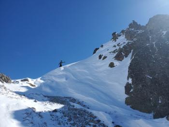
Avalanche danger is low. Use normal caution as you travel. Uneven surfaces, breakable crusts, and the potential for a slip or fall on steep icy slopes that terminate into exposed rocky patches are the main hazards to be mindful of.


Avalanche Problem 1: Normal Caution
-
Character ?

-
Likelihood ?CertainVery LikelyLikelyPossible
 Unlikely
 -
Size ?HistoricVery LargeLargeSmall

Warming temperatures should allow the snow surfaces to soften on solar aspects today. Triggering an avalanche is unlikely. Some areas host a mix of uneven surfaces and breakable crusts that may be challenging to backcountry travelers. Be willing to step back into safer terrain if instabilities or snow conditions that do not match your group's skill level are encountered.
Forecast Discussion
Concerns of wet snow avalanches are minimal today, but it's something to watch for as we transition into spring and the snow begins to melt. A wet snow avalanche is caused by snow losing its strength after becoming damp, moist or saturated with water. Wet snow avalanches typically release from a point and spread downhill, collecting more snow as they slide.
A Level I avalanche course is being offered March 5-7 through the College of the Siskiyous. Click here for more info.
Recent Observations
- Yesterday was clear with light easterly winds with moderate gusts.
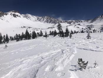
- Snow surface textures are variable including breakable melt-freeze crusts, icy patches, chalky wind-pressed sastrugi, and protected powder pockets.
- Near and above treeline terrain is very wind affected and largely scoured due to extreme northwesterly winds last week.
- A deeper snowpack remains below and near the treeline.
- Temperatures maxed out at 44 °F at 11 a.m. yesterday and averaged 33 °F over the past 24 hours at 7,600 feet on Mount Shasta.
- The total snow depth is 71 inches (180 cm) at our Old Ski Bowl weather station on Mount Shasta. Snow depth at our Mount Eddy Station is 58.4 inches (148 cm). Castle Lake has 62.1 inches (157 cm) on the ground, and Ashcreek Butte has 56.5 inches (143 cm).

Weather and Current Conditions
Weather Summary
Expect high-pressure to persist with warm days and cool nights throughout the workweek. The most recent models show a storm tracking toward our area late Friday night or Saturday morning. This storm looks to have a southerly flow associated with it and could bring the precipitation we desperately need.
24 Hour Weather Station Data @ 5:00 AM
| Weather Station | Temp (°F) | Wind (mi/hr) | Snow (in) | Comments | ||||||||
|---|---|---|---|---|---|---|---|---|---|---|---|---|
| Cur | Min | Max | Avg | Avg | Max Gust | Dir | Depth | New | Water Equivalent | Settlement | ||
| Mt. Shasta City (3540 ft) | 30 | 28 | 56 | 40 | 2 | N | ||||||
| Sand Flat (6750 ft) | 27 | 18 | 42 | 31 | 0 | 0 | 0 | 0 | Snow sensor down | |||
| Ski Bowl (7600 ft) | 26 | 22.5 | 44 | 33 | 71.7 | 0 | 0 | 0.2 | ||||
| Gray Butte (8000 ft) | 26.5 | 23.5 | 36.5 | 31.5 | 8 | 31 | E | |||||
| Castle Lake (5870 ft) | 29 | 21.5 | 44.5 | 33.5 | 62.1 | 0 | 1.5 | |||||
| Mount Eddy (6509 ft) | 31 | 28.5 | 42.5 | 34.5 | 2 | 6 | WSW | 58.3 | 0 | 0.5 | ||
| Ash Creek Bowl (7250 ft) | 28.5 | 22 | 44.5 | 31.5 | 56.5 | 0 | 0.5 | |||||
| Ash Creek Ridge (7895 ft) | 25.5 | 18.5 | 39.5 | 29 | 5 | 27 | S |
Two Day Mountain Weather Forecast
Produced in partnership with the Medford NWS
| For 7000 ft to 9000 ft | |||
|---|---|---|---|
|
Monday (4 a.m. to 10 p.m.) |
Monday Night (10 p.m. to 4 a.m.) |
Tuesday (4 a.m. to 10 p.m.) |
|
| Weather | Sunny | Mostly clear. | Sunny |
| Temperature (°F) | 41 | 26 | 46 |
| Wind (mi/hr) | South 10-15 | South 10-15 | South 5-10 |
| Precipitation SWE / Snowfall (in) | 0.00 / 0 | 0.00 / 0 | 0.00 / 0 |
| For 9000 ft to 11000 ft | |||
| Monday | Monday Night | Tuesday | |
| Weather | Sunny. Breezy. | Mostly clear. | Sunny |
| Temperature (°F) | 24 | 22 | 25 |
| Wind (mi/hr) | South 30-35 | Southwest 20-25 | Southwest 20-25 |
| Precipitation SWE / Snowfall (in) | 0.00 / 0 | 0.00 / 0 | 0.00 / 0 |
Season Precipitation for Mount Shasta City
| Period | Measured (in) | Normal (in) | Percent of Normal (%) |
|---|---|---|---|
| From Oct 1, 2023 (the wet season) | 13.58 | 29.50 | 46 |
| Month to Date (since Apr 1, 2024) | 2.14 | 7.23 | 30 |
| Year to Date (since Jan 1, 2024) | 10.00 | 14.29 | 70 |

